The longer you explore Michigan, the more it seems to keep a few surprises just out of view. A glass-clear spring, a moody stretch of shoreline, a forested overlook, or a place you somehow drove past for years can suddenly make the whole state feel new again.
These 12 standout Michigan attractions are the kind locals mention with a knowing grin because they still manage to impress even seasoned travelers. If your map has started to feel too familiar, this list is a strong reminder that Michigan still has plenty left to reveal.
1. Hartwick Pines State Park – Grayling, Crawford County
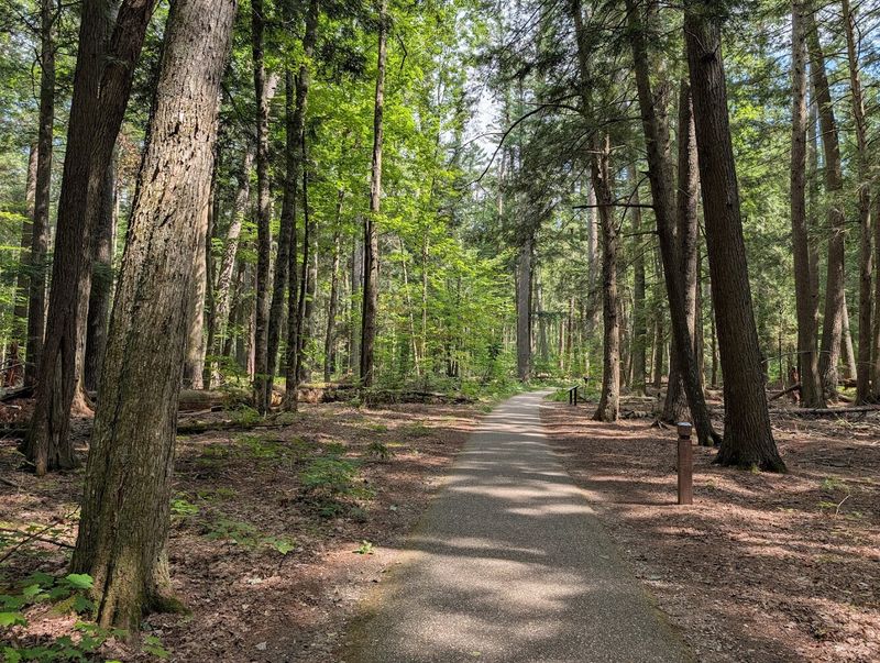
Hartwick Pines does not try to win you over with flashy overlooks or dramatic cliffs. It works in a quieter lane, using height, silence, and the kind of forest density that makes a regular walk feel reset in real time.
Step into the old-growth area and the scale changes fast, with trunks rising straight up and light filtering down in thin, cool bands. The park protects the largest remaining stand of old-growth white pine in Michigan’s Lower Peninsula, and that history is easy to feel once the trail begins closing around you.
The best part is how easy it becomes to notice smaller details after the biggest trees stop stealing all your attention. Needles soften the trail, birds cut through the stillness, and the air carries that clean resin scent northern Michigan does better than almost anywhere.
Even on a busier day, the woods absorb noise well enough that the park rarely loses its calm edge. The paved Old Growth Forest Trail also makes the experience approachable, leading visitors through the trees and toward the Hartwick Pines Logging Museum without demanding a strenuous hike.
That museum adds useful context without turning the visit into homework. Its exhibits and demonstrations explore Michigan’s 19th-century logging era, showing how the timber industry reshaped the state’s landscape, economy, and communities.
You start to understand Michigan timber country less as a chapter title and more as a place shaped by labor, weather, scale, loss, and long recovery.
If you only know Michigan for beaches and lake views, Hartwick Pines broadens the picture immediately. This is the state in vertical form, rooted, aromatic, and a little humbling once you stand under trees that have outlasted generations of roads.
Go expecting a simple forest stop, and you may leave talking about light, space, history, and silence with unusual seriousness.
2. Kitch-iti-kipi at Palms Book State Park – Manistique, Schoolcraft County
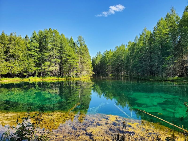
Kitch-iti-kipi has the kind of water that makes people stop mid-sentence. The spring is so clear and intensely colored that it barely reads as natural at first glance, more like glass laid over moving blue-green light than a pond tucked into the trees.
Then the surface shifts, clouds of sand rise from below, and the whole place starts looking even stranger in the best possible way.
Located inside Palms Book State Park, Kitch-iti-kipi is Michigan’s largest freshwater spring. More than 10,000 gallons of water move through cracks in the limestone every minute, maintaining a temperature of about 45 degrees year-round.
Those numbers explain some of the motion, but they do not fully prepare you for how vivid the spring looks in person.
The self-operated observation raft is part of the charm because it slows everyone down to the right speed. As you pull the platform across the pool, you can look straight through the clear water and pick out lake trout, ancient tree trunks, pale branches, and sand constantly shifting over the bottom.
Instead of rushing toward a viewpoint and leaving, you spend several unhurried minutes suspended directly above the main event.
This stop works especially well because it feels compact without feeling slight. You do not need a major hike or an all-day plan to get a memorable experience, making it an easy addition to a longer Upper Peninsula route.
The raft is accessible, and the viewing experience appeals to nearly every kind of traveler.
What stays with you is the color and motion together. The spring appears calm from one angle and active from another, changing with the light, cloud cover, and your position on the raft.
Michigan has no shortage of beautiful water, but few places offer this much clarity, movement, and quiet drama at close range.
3. Mackinac Island – Mackinac Island, Mackinac County
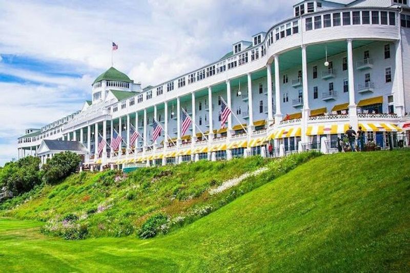
Mackinac Island gets talked about so often that some locals start mentally filing it under obvious. That is exactly why it can still catch people off guard when they return and remember how distinctive the entire setup feels, with ferry arrivals, steady bicycle traffic, horse-drawn movement, and a downtown operating at a rhythm completely different from the mainland.
The island is familiar, but it never feels flat.
You can treat it as a postcard stop and still have a good time, yet it becomes more interesting once you move beyond the busiest blocks. The 8.2-mile ride around M-185 follows the island’s shoreline, trading bustling storefronts for limestone formations, open views across Lake Huron, wooded stretches, and places where the breeze does most of the talking.
Inland, the roads and trails feel greener, quieter, and removed enough from downtown to change the mood of the trip.
That contrast is possible because Mackinac Island State Park covers more than 80 percent of the island. There are miles of routes for walking, biking, and horseback riding, giving visitors plenty of room to explore beyond the most recognizable landmarks.
Motor vehicles have also been heavily restricted for well over a century, with transportation centered mainly on bicycles, horses, and walking.
Architecture does heavy lifting here, too. Broad porches, historic hotels, summer cottages, church steeples, and brightly painted trim contribute to an island look that feels polished without becoming sterile.
Even small details matter, from the sound of hooves on pavement to rows of bicycles parked where cars would normally dominate the frame.
Mackinac works because it creates a complete environment rather than one headline attraction. You are not simply checking off a viewpoint and leaving.
You are entering a place with its own pace, textures, sounds, and social choreography. That is why people who think they already know it often end up rediscovering it once they slow down enough to coast, wander, and notice more than the obvious.
4. Saugatuck Dunes State Park – Saugatuck, Allegan County
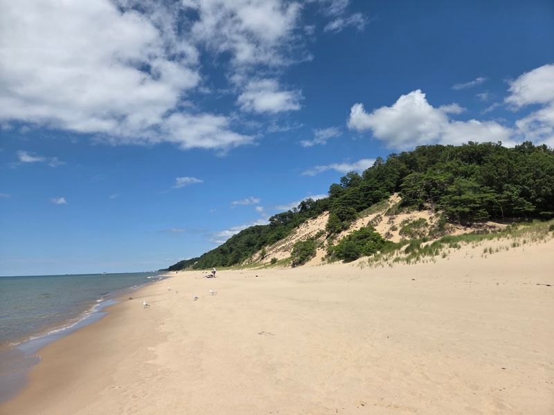
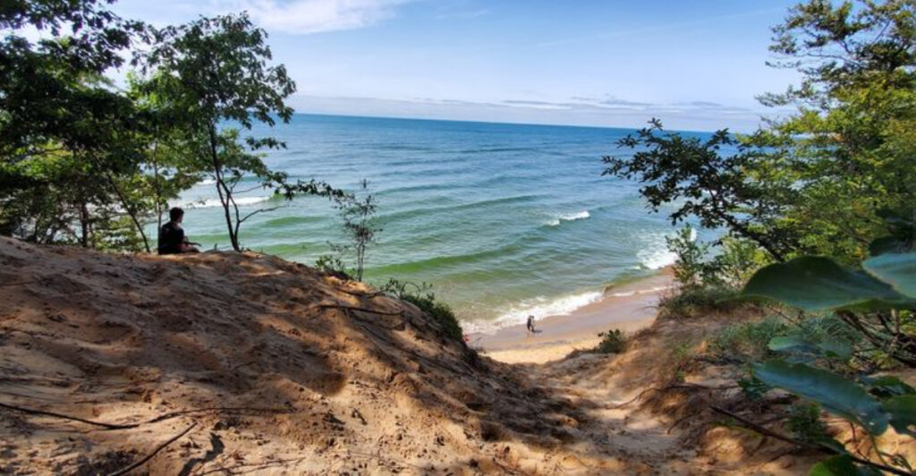
Reaching the shoreline takes a little effort here, and that is part of what makes the experience work. The walk through wooded dunes builds anticipation in stages, beginning with shaded trail sections, then brighter openings, and finally the first hints of Lake Michigan ahead.
By the time sand replaces packed earth underfoot, the beach arrival lands with far more impact than a parking-lot viewpoint ever could.
Saugatuck Dunes State Park is especially good at creating contrast. Inland sections feel enclosed and textured, with roots, leaves, dune slopes, and shifting light, while the beach opens wide into space, wind, and rolling water.
That transition gives the park a stronger sense of movement than many coastal stops because you experience the landscape changing around you instead of simply stepping out and seeing everything at once.
There is also room to shape the visit around your energy level. The park has four marked trails crossing rolling, sandy terrain, including the Beach Trail, the shortest route to Lake Michigan.
Altogether, visitors can explore about 13 miles of trails and 2.5 miles of sandy shoreline, so the experience can be a focused beach walk or a longer outing through forested dunes and natural areas.
Once you reach the water, some visitors settle near the main access point, while others continue along the shore to find quieter stretches framed by grasses and rising sand. Depending on the weather, the lake can appear bright and breezy, steel-blue and dramatic, or soft and hazy beneath a warmer sky.
For anyone who thinks west Michigan beach outings are interchangeable, this park quickly disproves the idea. The dunes add shape, the trails create pacing, and the secluded setup changes the energy from a social scene into a scenic excursion.
It is a reminder that a beach can become memorable before you even see the water, provided the approach is staged this well.
5. Porcupine Mountains Wilderness State Park – Ontonagon, Ontonagon County
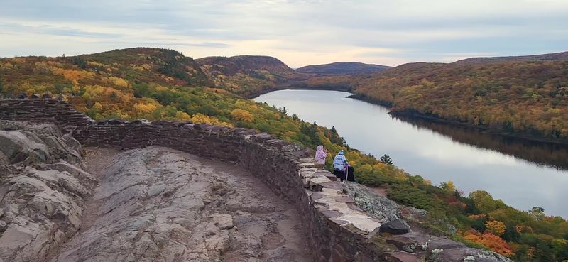
Few landscapes in Michigan make the state feel quite this large. Ridges stack into the distance, forests appear to run without interruption, and even the better-known overlooks suggest far more terrain beyond the edge of whatever you can currently see.
In a state filled with polished waterfront views and easy scenic stops, the Porcupine Mountains speak a bigger, rougher visual language that stands apart immediately.
Part of that impact comes from the sheer range packed into the park. Covering roughly 60,000 acres, Michigan’s largest state park includes old-growth forest, Lake Superior shoreline, waterfalls, rivers, rocky ridges, and more than 90 miles of hiking trails.
You can move from broad overlooks into dense woods, trade roadside scenery for quieter interior routes, or turn a short visit into a full day of elevation, changing weather, and genuine backcountry depth.
Lake of the Clouds receives much of the attention, and the view across the valley certainly earns its reputation. Still, the wider park matters just as much.
Trails follow escarpments, descend alongside rivers, pass waterfalls, and continue toward the Lake Superior coast. Smaller pauses at trailheads, roadside pullouts, and wooded clearings all contribute to the feeling that you are moving through a place with serious room to breathe.
What makes the Porcupine Mountains memorable is how stubbornly they resist being compressed into one photograph. Every bend suggests another valley, another ridge, or another trail disappearing into deep green.
For lifelong Michigan explorers who think they have already seen the state at its wildest, this park often resets the scale. It reminds you that wilderness can still feel expansive, layered, and pleasantly difficult to summarize, especially when Lake Superior, old forest, and rugged terrain all occupy the same enormous frame.
6. Castle Rock – St. Ignace, Mackinac County
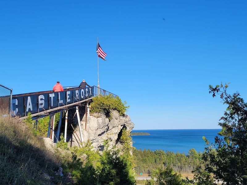
Some roadside stops deliver far more scenery than their modest footprint suggests. From the highway, this limestone formation may look like a quick curiosity, but the view from the top turns it into something much more memorable.
Rising about 195 feet above the nearby water level, Castle Rock creates an elevated perspective over Lake Huron, surrounding forest, and the wider St. Ignace area that is difficult to appreciate from the road below.
The approach is simple and direct, which works in its favor. A staircase leads to the summit observation platform, requiring a short burst of effort rather than a long hike or complicated itinerary.
That makes the attraction especially effective on travel days, when time is limited but your brain still wants one strong visual before getting back behind the wheel.
At the top, the appeal is less about delicate detail and more about bold geography. On a clear day, the view can extend for nearly 20 miles, with Lake Huron, downtown St. Ignace, Mackinac Island, and broad stretches of wildlife habitat visible from the perch.
Wind, height, and the exposed platform do most of the work, while the open horizon helps the surrounding region fall into place.
The attraction also carries the unmistakable personality of a classic northern Michigan roadside stop. Giant statues of Paul Bunyan and Babe the Blue Ox stand near the entrance, adding a playful layer of vintage travel culture before the climb begins.
Castle Rock may not be the most complex destination on this list, but it does exactly what a roadside landmark should do. It offers a recognizable place, a clear payoff, and a viewpoint that makes the region feel newly organized for a few minutes.
Sometimes that is enough: a staircase, a massive rock, and a better angle on northern Michigan.
7. Sleeping Bear Dunes National Lakeshore – Empire, Leelanau County
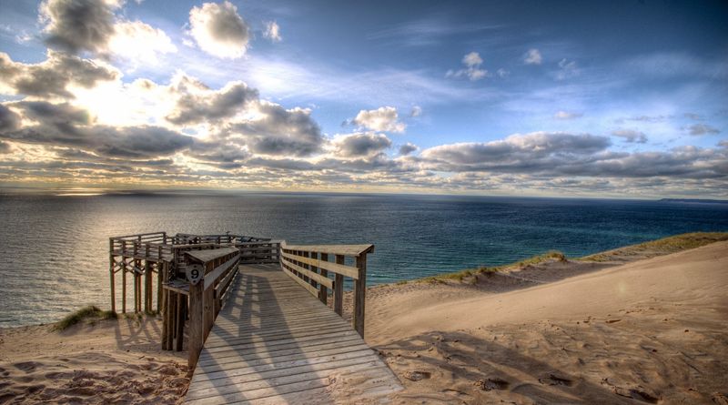
Fame has done very little to soften the impact of this shoreline. Even visitors who have studied the photographs for years can still be caught off guard when pale sand, deep blue water, and enormous bluffs finally share the same frame.
The scale feels immediate, especially from the higher viewpoints where Lake Michigan seems to stretch beyond the edges of the landscape.
Sleeping Bear Dunes National Lakeshore works because the dunes are only one part of a much broader setting. The protected area includes 35 miles of Lake Michigan beaches, towering bluffs, inland lakes, rivers, forests, and two offshore islands.
That variety keeps a visit from settling into one visual pattern. A morning can move from wooded roads to sandy overlooks, then continue toward a beach where the horizon feels completely open.
The 7.4-mile Pierce Stocking Scenic Drive offers one of the easiest ways to understand that range. Its route passes through beech-maple forest and reaches overlooks of Glen Lake, Lake Michigan, and the dunes, with multiple stops that encourage visitors to slow down rather than treat the park as one quick viewpoint.
Some bluffs rise about 450 feet above the lake, creating the dramatic drops that give the shoreline its unmistakable profile.
What stands out most is the relationship between color and shape. Pale sand, green forest, blue water, and shifting sky form strong contrasts, while wind-sculpted landforms change character with the weather.
On clear days, the scenery appears crisp and almost graphic. Under clouds, shadows settle into the dune curves and make the entire coast feel moodier and more layered.
That is why repeat visits rarely feel repetitive. A different road, trail, beach, season, or quality of light can reveal another version of a place many locals assume they already know.
8. Presque Isle Park – Marquette, Marquette County
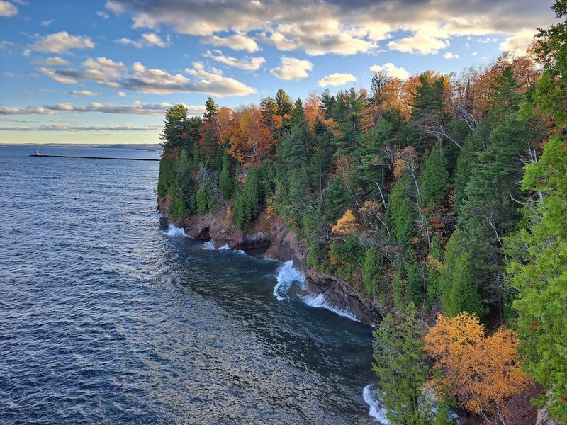
Lake Superior rarely presents the same face twice along this compact peninsula. Rock, wind, water, and forest sit close together, and the curving shoreline keeps revealing the lake from new angles.
Instead of building toward one grand overlook, the experience unfolds as a sequence of smaller shoreline moments, each carrying its own texture, light, and mood.
Presque Isle Park occupies a 323-acre forested headland at the northern edge of Marquette, extending into Lake Superior while remaining remarkably easy to reach from the city. A roughly 2.7-mile paved loop circles the peninsula, allowing visitors to drive, walk, or bike between wooded stretches, rocky outlooks, and open-water views without committing to a complicated route.
That rhythm is a major reason the park stays in your memory. One stop may emphasize dark stone and waves breaking against the edge, while another opens onto broad blue water or a quieter curve sheltered by trees.
The well-known Black Rocks area adds another layer of visual drama, with ancient-looking stone meeting the lake in a way that feels far removed from downtown Marquette only minutes away.
The park’s accessibility never completely domesticates it. Weather can change the mood quickly, turning bright water steel-gray or sending wind hard across the exposed shoreline.
Visitors can adjust the outing just as easily, lingering at overlooks, following footpaths, or completing the full loop according to the light and conditions.
What makes Presque Isle stand out is how efficiently it captures Lake Superior’s personality in several forms at once. It can appear inviting, severe, calm, or restless within a single visit.
For locals who have only passed through quickly, returning with time to pause may be the simplest way to remember why this shoreline holds such lasting power.
9. Tahquamenon Falls State Park – Paradise, Chippewa County
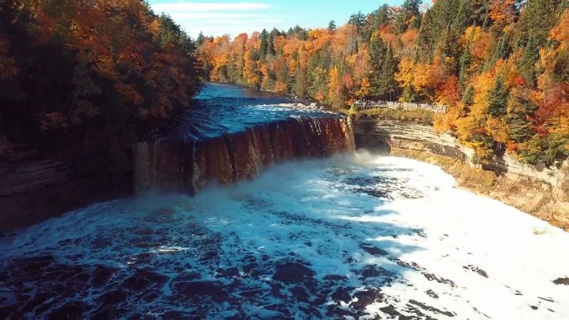
Sound reaches you before the full view does. Water pounds through the forest with enough force to announce what is ahead, then flashes between the trees before the Upper Falls finally opens into view.
The broad curtain drops about 50 feet, carrying the Tahquamenon River over the edge in a rush of amber water, spray, and steady noise.
That unusual color gives the scene much of its personality. Tannins released by cedar, spruce, and hemlock swamps upstream tint the river a rich brownish-orange, creating the famous “root beer” appearance.
Instead of the icy blue or clear tones people often associate with waterfalls, Tahquamenon brings a deeper, earthier palette that looks striking against green summer forest, gray skies, fresh snow, or peak autumn color.
The park also supports several kinds of visits without allowing its headline attraction to lose focus. A new 1,100-foot accessible boardwalk at the Upper Falls provides close panoramic views of the river and waterfall.
Visitors with more time can explore the Lower Falls, follow shorter paths through the woods, or tackle the challenging 5.1-mile River Trail connecting the two main waterfall areas. Farther downstream, the river offers paddling access and eventually reaches Whitefish Bay.
That range prevents the experience from becoming a quick photograph followed by an immediate departure. The falls remain the anchor, but old-growth forest, trails, river scenery, and changing conditions give the wider landscape enough depth to reward a slower visit.
Even people who have seen plenty of waterfalls elsewhere tend to remember this one. Its width, color, sound, and forest framing create more presence than a height measurement can explain.
When Michigan landmarks begin blending together in memory, Tahquamenon snaps the picture back into focus with water that moves powerfully, looks unmistakable, and leaves little doubt about where you are.
10. Miners Beach – Munising, Alger County
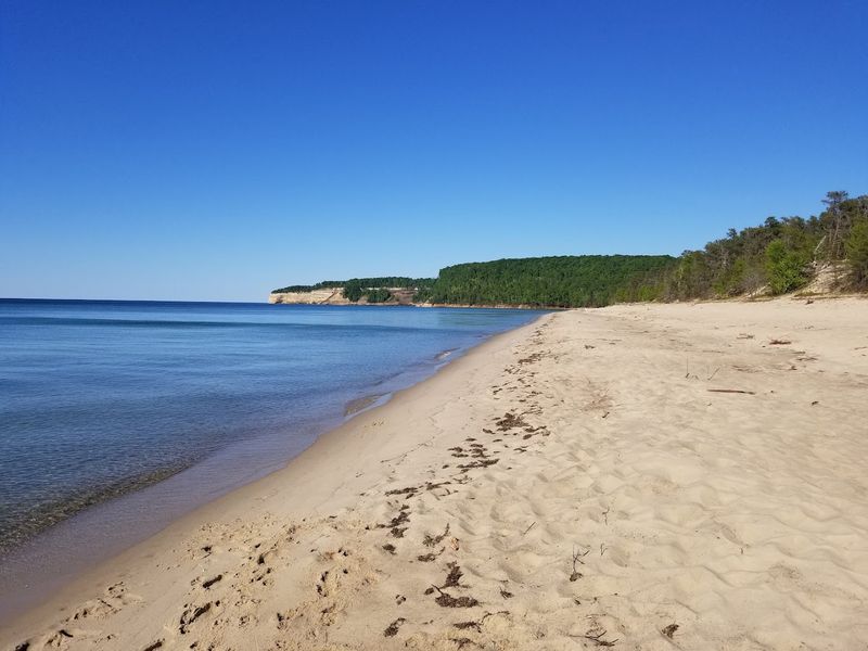
A broad sweep of sand opens beneath forested slopes, giving Lake Superior room to feel welcoming without ever becoming tame. The beach stretches for nearly a mile, mixing sand with scattered stones and framing the water with cliffs, trees, and distant rock.
That combination makes the setting feel easiergoing than some of Pictured Rocks’ more dramatic overlooks, but never plain.
Miners Beach succeeds through balance. There is enough open shoreline for strolling, sitting, and watching the lake change color, yet the surrounding landscape keeps the view from flattening into one long horizon.
At the western end, Miners River enters Lake Superior beneath the forested slope near Miners Castle. Farther east, small Elliot Falls reaches the beach where sand meets cliff, adding another reason to keep walking instead of settling in one place.
Access is also relatively straightforward. From the main western parking area, a short wheelchair-accessible boardwalk passes through pine forest and a picnic area before reaching a viewing platform above the beach.
From there, stairs lead down to the sand, while additional access points sit farther along the shoreline. On clear days, Bridalveil Falls may also be visible in the distance against the cliffs to the east.
Lake Superior still controls the mood. Calm weather can polish the surface into bands of blue and green, while wind and cloud cover bring sharper waves, darker tones, and a stronger sense of scale.
The same shoreline can feel gentle one hour and severe the next.
For travelers who know Munising mainly through boat tours and cliff photographs, Miners Beach offers a slower angle on the region. It trades vertical drama for space, movement, and the simple pleasure of letting Superior unfold at walking pace.
11. Isle Royale National Park – Isle Royale, Keweenaw County
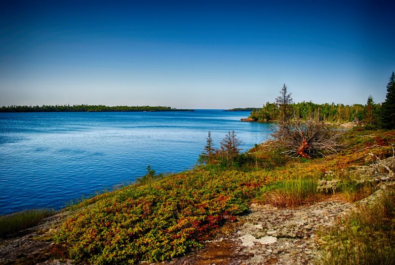
The journey begins well before your feet touch the island. Reaching this remote stretch of Lake Superior requires a ferry, seaplane, or private watercraft, and that extra commitment gives the experience a different weight from the start.
There are no roads leading in and no cars waiting on shore. Once you arrive, rocky coves, cold water, and thick northern forest confirm that everyday Michigan has been left far behind.
Much of Isle Royale’s appeal comes from pace and separation. Narrow trails, sheltered bays, ridgelines, and long shoreline stretches reward attention rather than hurry, while Lake Superior reinforces the sense of distance from normal routines.
The park draws backpackers and hikers, but it also offers room for paddling, boating, fishing, and diving, allowing visitors to experience the island from both land and water.
Because the park sits beyond the usual Michigan travel loop, it remains one of the largest gaps in many locals’ in-state résumés. That makes finally seeing it especially satisfying.
You are not simply adding another scenic stop to a list. You are entering a designated wilderness where transportation, weather, and geography shape the trip as much as any individual viewpoint.
Ferry schedules require planning, lake conditions can affect arrivals, and even getting from one part of the island to another demands more intention than a typical park visit.
Isle Royale stands out less through one iconic image than through total immersion. Shoreline rock, interior woods, quiet coves, and the logistics of crossing Superior combine into one complete northern experience.
For travelers who prefer destinations with a little friction, substantial silence, and room to disconnect, few places in Michigan change the frame this thoroughly.
12. Pictured Rocks National Lakeshore – Munising, Alger County
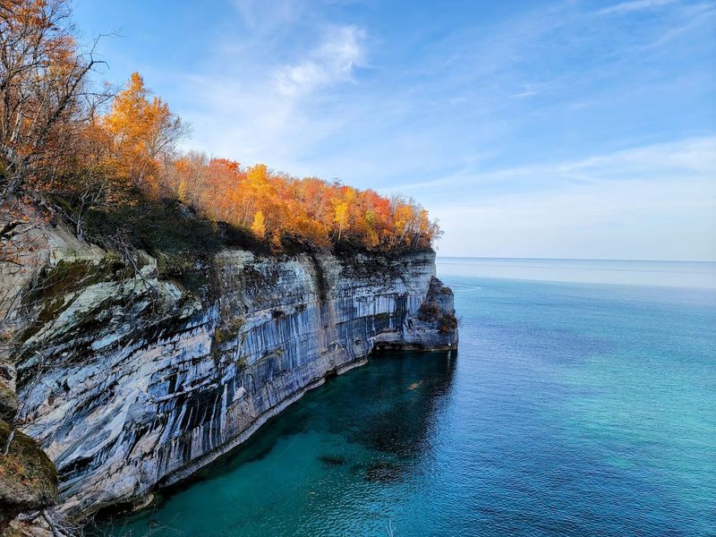
Few Michigan shorelines look this deliberately composed. Sandstone cliffs rise above Lake Superior in long bands of red, orange, green, brown, and white, while forest crowns the rock and cold blue water stretches below.
Even locals who have studied the photographs for years can find themselves pausing when the full scale finally comes into view.
The namesake cliffs extend for roughly 15 miles and rise between 50 and 200 feet above the lake. Their color comes from groundwater seeping through cracks in the sandstone and carrying minerals across the rock face.
Iron creates red and orange tones, copper produces blue and green, manganese leaves darker streaks, and limonite adds white. Weather and erosion continue shaping arches, caves, pillars, and recessed walls along the coast.
Part of the appeal is how many ways there are to read the landscape. From overlooks and trails, the cliffs and water form broad compositions with depth and scale.
From a boat or kayak, smaller features sharpen into view, including mineral streaks, weathered textures, rock openings, and abrupt changes in color. The National Park Service notes that the cliff layers and staining are best appreciated from the water, especially when lower sunlight strengthens the contrast.
Lake Superior matters just as much as the stone. Near the cliffs, the water may appear turquoise or green before deepening to dark blue farther out.
Wind, cloud cover, and shifting light can make the same section of shoreline feel bright and graphic one moment, then severe and layered the next.
Pictured Rocks earns its reputation because it is not one famous viewpoint. It is a long, varied coast of cliffs, beaches, waterfalls, dunes, forest, and open water.
For anyone who has lived in Michigan without properly seeing it, the omission becomes obvious as soon as those colored walls appear.
Share this story