Somewhere along a quiet stretch of highway in northern Michigan, there is a stone monument that marks something most people never think about: the exact halfway point between the equator and the North Pole.
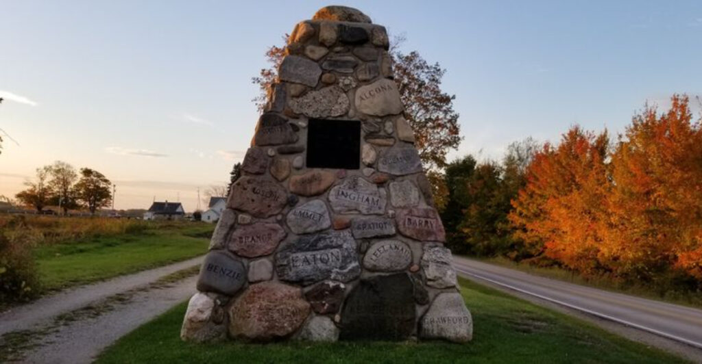
The Hugh J. Gray Cairn sits near Kewadin, right on the 45th parallel, and it carries more meaning than its modest size might suggest. Built from stones gathered across every single county in Michigan, it is a tribute to both geography and the man who helped shape Michigan tourism.
Pull over, take a closer look, and you will find yourself standing at a spot that connects the whole state in one quiet, rocky pile.
The 45th Parallel: Standing Exactly Halfway Between Two Extremes

Most people drive through northern Michigan without realizing they are crossing one of the most geographically interesting lines on the planet. The 45th parallel runs right through this part of the state, marking the point that sits precisely halfway between the equator and the North Pole.
That is 2,500 miles in each direction, give or take, and the Hugh J. Gray Cairn sits right on that line.
What makes this more than just a trivia fact is how the cairn turns an invisible line into something you can actually touch. There is no digital display, no flashy signage.
Just a carefully built stone monument beside the road, quietly doing its job of marking a place that most atlases skip over entirely.
When you stand there, the air off Grand Traverse Bay sometimes drifts through the old maple trees lining the turnout. It feels like an ordinary roadside stop until you process what the location actually means.
You are not close to the middle of something. You are exactly at it.
Travelers heading between Petoskey and Traverse City pass this spot regularly, and plenty of them roll right by. The ones who stop tend to linger longer than expected.
There is something about the combination of geography, stone, and silence that makes people slow down.
The road itself, now called Cairn Highway, carries the name of the monument rather than the other way around. That detail alone says something about how the community values this marker.
The 45th parallel runs through several states and countries, but this particular stretch of it has a stone monument, a name, and a story attached to it that most parallel crossings simply do not have.
Hugh J. Gray: The Man Behind the Marker

Not every roadside monument gets named after a real person with a real story, but this one does. Hugh J.
Gray was known as the Dean of Michigan Tourism, a title that reflects how seriously people took his work in promoting the state as a destination worth visiting. He was not a politician or a celebrity.
He was someone who genuinely believed Michigan had something worth showing the world.
The cairn was built as a tribute to his contributions. That framing matters because it shifts the monument from being purely geographic to being something more personal.
Someone cared enough about this man’s work to gather stones from every county in the state and stack them into a lasting tribute on a highway that used to be one of the main north-south routes through Michigan.
Before US-131 was rerouted further west, this road carried significant traffic. Travelers moving up and down the Lower Peninsula would pass right by this spot.
That means Gray’s monument once had a much larger daily audience than it does now. The rerouting changed the traffic patterns, but the cairn stayed put.
Learning about Gray adds a layer to the stop that the stones alone cannot communicate. He represents a time when promoting a place meant getting people to slow down and pay attention to what was already there, which is a philosophy that feels oddly relevant today.
There is no elaborate museum nearby, no interpretive center with touchscreen displays. Just a stone structure with his name attached to it and a highway that carries his legacy in its very title.
For someone who dedicated his career to Michigan, that quiet permanence seems fitting.
Every County in Michigan, Stacked Into One Place

Here is the detail that tends to stop people mid-sentence when they hear it: each stone in the cairn came from a specific Michigan county, and that county’s name is inscribed on it. All of them.
The Upper Peninsula counties, the thumb counties, the ones tucked along Lake Michigan and the ones pressed against the Ohio border. Every single one is represented here in physical form.
That means the cairn is not just decorative stonework. It is a geographic catalog of the entire state, assembled in one place on the 45th parallel.
Running your eyes across the stones and reading county names becomes its own kind of slow road trip through Michigan without moving an inch.
The craftsmanship holds up well. Visitors regularly comment on the quality of the masonry, and it is easy to see why.
The stones are set in concrete but arranged with clear care and intention. Some are smooth, some rough, some clearly sedimentary and others with a more granular texture that hints at different geological zones across the state.
One reviewer noted that Oceana County appeared to be missing during their visit, which adds a small mystery to the whole thing. Whether that stone was displaced, damaged, or simply harder to spot, it is the kind of detail that makes people look more carefully at every inch of the structure.
Standing in front of it and trying to find a specific county becomes almost a game. Families with kids tend to turn it into a challenge, which is probably the best possible reaction a stone monument could inspire.
No app required, no tickets needed. Just eyes, curiosity, and a list of Michigan counties to check off one by one.
The Old Highway That Used to Run Through Here

Roads tell stories, and Cairn Highway has a longer one than most. Before US-131 was shifted west, this corridor was a primary artery for north-south travel through Michigan.
Drivers heading up toward Petoskey or down toward Traverse City would have passed the cairn regularly, making it a familiar landmark rather than a detour.
The rerouting changed everything about the traffic flow here. What was once a busy highway became something quieter, more local, less rushed.
In a way, that shift actually preserved the mood of the stop. The cairn now sits along a road that feels like it belongs to a different era, lined with large old maples that create a canopy effect in summer.
Cyclists have discovered this corridor in a way that car travelers rarely do. One reviewer mentioned stopping here regularly on bike rides to cool off under the maple shade and catch a breeze off the bay.
That kind of repeat visit from a non-motorist says something interesting about how the place functions now. It has become a rest point, a breathing spot.
The name Cairn Highway is itself a remnant of the monument’s former prominence. Roads do not usually get named after roadside stops unless those stops meant something significant to the community.
The name stuck even as the traffic thinned, which suggests the cairn earned its place in the local identity long before the highway was rerouted.
Driving this stretch today, you get a sense of what northern Michigan roads felt like before the interstate era reshaped everything. The pace feels slower here, the trees feel closer, and the monument at the side of the road feels less like a tourist attraction and more like something that simply belongs.
What It Actually Looks Like When You Pull Over

Expectations matter at roadside stops. Pull up with the wrong mental image and you might drive away disappointed.
Pull up with no expectations at all and the cairn has a decent chance of surprising you. The structure is larger than most people picture from descriptions alone.
It is not a small pile of rocks. It is a proper monument, built to be noticed from a moving vehicle.
The turnout area is modest but functional. There is enough room to park without blocking traffic, and the shade from the surrounding maples makes stopping in warmer months genuinely pleasant.
A breeze off Grand Traverse Bay occasionally reaches this spot, which is the kind of detail that does not show up on any tourism website but makes a real difference on a warm afternoon.
Up close, the stonework draws attention. The variety of rock types is visible even to someone without any geology background.
Some stones are clearly different in color, grain, and weight from their neighbors. That visual variety reflects the actual geological diversity of Michigan, which spans dramatically different rock formations from the Upper Peninsula to the southern Lower Peninsula.
The inscribed county names are legible but require some attention. Some are easier to read than others depending on the stone surface and weathering.
Spending a few minutes actually reading them all is a different activity than glancing at the cairn from the parking area. The monument rewards the people who get close.
There is no gift shop, no entrance fee, and no guided tour. Just a cleared turnout, a stone structure, some old trees, and the quiet of a road that used to be busier than it is now.
That simplicity is not a limitation. For a lot of visitors, it turns out to be the whole point.
Why the 45th Parallel Matters More Than You Might Think

Geography class rarely makes the 45th parallel sound interesting. It is just a number, a line on a map, one of many.
But standing at a physical marker on that line has a way of making the abstraction real in a way that no classroom map ever quite manages. You are genuinely at the midpoint of the northern half of the planet.
The 45th parallel passes through several well-known places around the world, including parts of France, northern Italy, and portions of the western United States. Michigan is not usually the first state people associate with significant geographic coordinates, which makes this spot a small but satisfying surprise for anyone paying attention.
From a practical standpoint, the 45th parallel also marks a climate transition zone. Regions near this latitude experience a mix of continental and temperate influences.
Northern Michigan’s weather patterns, including its lake-effect snow, distinct seasonal shifts, and relatively mild summers compared to lower latitudes, reflect this geographic position in ways that are easy to observe but harder to explain without context.
The cairn makes that context tangible. It gives the parallel a physical anchor in a state that most people associate with lakes and forests rather than global geography.
Connecting those two identities, the natural landscape and the planetary coordinates, is something the monument does without trying too hard.
For travelers who enjoy collecting unusual geographic milestones, the 45th parallel crossing in Michigan is genuinely distinctive. There is no elaborate infrastructure here, no theme park built around the concept.
Just a stone cairn, a highway named after it, and a location that sits exactly where the math says it should. Sometimes the simplest markers leave the most room for a visitor’s own imagination to fill in the rest.
Making the Stop Part of a Larger Northern Michigan Drive

The cairn sits in a sweet spot between two of northern Michigan’s most visited towns. Petoskey is a short drive to the north, Traverse City to the south.
Both have restaurants, shops, waterfront areas, and the kind of energy that draws visitors year after year. The cairn sits between them, off the main highway, on a quieter road that connects the two without the usual commercial noise.
Routing a drive to include the cairn takes almost no extra time if you are already heading between those two towns. The detour is minimal and the road itself is worth taking even if the monument did not exist.
The maple canopy, the rural pace, and the occasional glimpse of the bay make Cairn Highway a pleasant alternative to the faster route.
Cyclists have already figured this out. The road’s reduced traffic and scenic quality make it a popular route for people on bikes, and the cairn serves as a natural midpoint rest stop.
Shade, a slight breeze, and a monument worth a photo or two. That combination works whether you arrive by bicycle or by car.
Families traveling with kids tend to respond well to the county-naming game the cairn naturally invites. Older travelers often appreciate the historical context, particularly the connection to Michigan tourism history.
The stop works across a wide range of travel styles without requiring any particular preparation or prior knowledge.
One thing worth noting is that the area around Kewadin sits near Elk Rapids and the eastern shore of Grand Traverse Bay. If the cairn is your first stop, there is plenty of lakeshore, local food, and quiet roads waiting nearby.
The monument is not a destination in isolation. It fits naturally into a part of Michigan that rewards slow, curious travel.