The Great Smoky Mountains hold some of the most spectacular hiking trails in all of Tennessee, where misty peaks meet ancient forests and waterfalls tumble over moss-covered rocks. Whether you’re chasing sunrise views from rocky overlooks or seeking quiet moments beneath towering hemlocks, these paths offer something magical for everyone who laces up their boots.
From family-friendly strolls to challenging climbs that test your endurance, each trail tells its own story through the landscape. Get ready to explore twelve incredible routes that showcase why the Smokies remain Tennessee’s crown jewel for outdoor adventure.
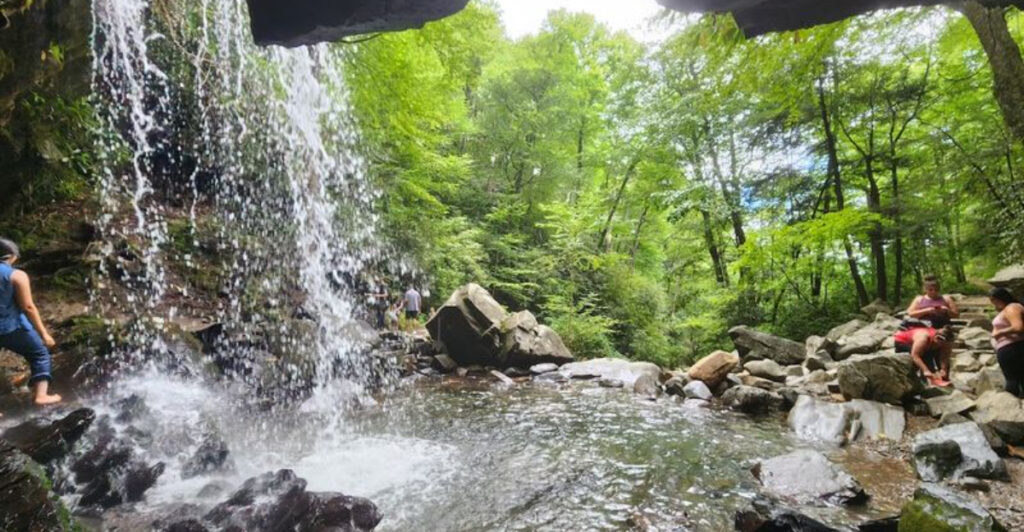
1. Alum Cave Trail — Great Smoky Mountains National Park

Rock formations here look like something from another planet, with mineral deposits painting the cave walls in shades of rust and gold. The path climbs steadily through old-growth forest before reaching the famous Alum Cave Bluffs, where a massive overhanging rock creates natural shelter.
About halfway up, you’ll cross Arch Rock, a tunnel carved right through the mountain that makes you feel like you’re entering a secret world. Steel cables bolted into the cliffside help steady your steps along the steeper sections, adding just enough adventure to keep your heart pumping.
Hikers often spot salamanders along the wet sections of trail, reminding you that these mountains teem with hidden life. The elevation gain totals around 2,500 feet over five miles, so your legs will definitely know they’ve been hiking.
Early morning visits reward you with fewer crowds and better chances of spotting wildlife browsing the understory. If you continue past the bluffs, the trail eventually connects to Mount LeConte’s summit, though most folks turn around at the dramatic rock shelter.
Spring brings wildflowers carpeting the forest floor, while fall transforms the canopy into a blazing tapestry of reds and golds that photographs never quite capture right.
2. Charlies Bunion Trail — Great Smoky Mountains National Park

Named after a hiker’s protruding foot bunion, this rocky outcrop juts dramatically into open air like Tennessee’s answer to a natural observation deck. A 1925 wildfire stripped the vegetation here, and subsequent erosion exposed the bare rock spine that now defines this iconic viewpoint.
The eight-mile roundtrip journey follows part of the legendary Appalachian Trail, winding through spruce-fir forests that feel positively enchanted when fog rolls through. You’ll gain about 1,600 feet in elevation, with the steepest climbing happening in the first couple miles before the grade mellows out.
Once you reach the bunion itself, the 360-degree views stretch across wave after wave of blue-tinged peaks that seem to go on forever. It’s the kind of place where you understand why people fall completely in love with these mountains.
Pack extra layers because temperatures drop noticeably as you climb, and winds whip across the exposed rock with surprising force. The trail stays busy during peak season, but there’s usually enough room on the rock for everyone to find their own perch.
Sunset hikes are absolutely stunning here, though you’ll need headlamps for the descent and should know the trail reasonably well before attempting an after-dark return.
3. Rainbow Falls Trail — Gatlinburg

Water plunges 80 feet over a massive rock face, and when afternoon sun hits the mist just right, actual rainbows dance in the spray—hence the perfectly descriptive name. This five-and-a-half-mile roundtrip hike ranks among Gatlinburg’s most popular destinations, drawing crowds who consider the 1,500-foot elevation gain worthwhile for such a spectacular payoff.
The trail follows LeConte Creek for much of the journey, with smaller cascades and pools providing preview entertainment before the main attraction. You’ll cross the creek multiple times on log footbridges that can get slippery, so watch your footing and maybe save the Instagram scrolling for later.
Rhododendron tunnels create natural archways along certain sections, and when they bloom in late spring, the mountainside erupts in pink and white flowers. Winter visits transform the falls into a frozen sculpture, with ice formations building into massive pillars that look otherworldly.
The final approach gets steep and rocky, requiring some careful navigation over roots and stones worn smooth by thousands of boots. Mist from the falls drenches everything within twenty feet, so waterproof gear protects your phone and keeps you from getting uncomfortably soaked.
Spring runoff creates the most dramatic flow, though summer’s lower water volume actually produces better rainbow conditions when combined with afternoon sun angles.
4. Abrams Falls Trail — Cades Cove

Don’t let the 20-foot height fool you—Abrams Falls compensates for modest vertical drop with tremendous volume, sending water crashing into a deep pool with enough force to create constant thunder. The five-mile roundtrip from Cades Cove feels like a journey into wilderness, leaving behind the valley’s open meadows for dense forest that closes in around you.
The trail undulates more than you’d expect, with enough ups and downs to keep things interesting without becoming grueling. You’ll cross several smaller streams on footbridges, and spring wildflowers absolutely carpet the forest floor in places.
Abrams Creek itself accompanies much of the hike, providing soundtrack and scenery as it rushes over rocks and through narrow channels. The pool at the falls base looks incredibly inviting on hot days, but swimming here has claimed lives—strong currents and underwater obstacles make it genuinely dangerous despite the tempting appearance.
Cades Cove’s popularity means parking can be challenging, especially on weekends when the loop road gets jammed with wildlife watchers. Starting early gives you quieter trails and better chances of spotting deer, turkeys, or even black bears along the route.
The return hike always seems longer than the way in, a universal trail truth that never fails to surprise people who should know better by now.
5. Laurel Falls Trail — Great Smoky Mountains National Park

Paved all the way to the falls, this 2.6-mile roundtrip trail welcomes strollers, wheelchairs, and anyone who wants waterfall rewards without technical hiking challenges. The wide, smooth path makes Laurel Falls the park’s most accessible cascade, which also makes it the most crowded on nice weekends.
An 80-foot drop splits into upper and lower sections, with water sliding over rock layers like nature’s own staircase. The paved trail ends at a viewing area with guardrails, though you’ll spot adventurous souls scrambling on rocks for different photo angles—not recommended and technically against park rules.
Mountain laurel bushes give the falls its name, and when they bloom in late spring, the pink and white flowers create a gorgeous frame for waterfall photos. The relatively gentle grade makes this perfect for families with younger kids who are just getting into hiking.
Despite the pavement, the trail still requires reasonable caution—it’s narrow in places with drop-offs, and that smooth surface gets dangerously slick when wet. Parking fills up fast, often by mid-morning during peak seasons, forcing latecomers to wait for spaces or return another day.
The trail also serves as a popular winter destination when other routes become icy nightmares, though even pavement can freeze, so traction devices help during cold snaps that turn everything into a skating rink.
6. Grotto Falls Trail — Gatlinburg

Walking behind a waterfall sounds like something from an adventure movie, but Grotto Falls makes it reality on a family-friendly 2.6-mile roundtrip trail. The path winds through old hemlock forest before reaching the 25-foot cascade that you can actually walk completely behind, staying mostly dry if you time your passage between wind gusts.
This trail serves double duty as a supply route for LeConte Lodge, so you might encounter llamas carrying provisions up the mountain—yes, actual llamas, making the hike even more memorable for kids. The relatively easy grade gains only about 500 feet, making it accessible for most fitness levels.
Trilliums and other spring wildflowers bloom prolifically along the creek, and the forest canopy creates a cool, shaded environment even on hot summer days. The grotto itself stays damp year-round, supporting mosses and ferns that thrive in the constant mist.
Rock walls behind the falls glisten with moisture and mineral deposits, creating a magical backdrop for photos that never quite capture how it feels to stand there. Winter freezes can partially ice over the falls, creating dramatic icicle curtains, though the trail behind becomes treacherous and sometimes impassable.
The return hike goes quickly, all downhill, though knees might protest a bit depending on your trekking pole situation and how much mileage they’ve already logged this season.
7. Chimney Tops Trail — Great Smoky Mountains National Park

Two rocky peaks jut skyward like chimneys, giving this trail its name and its reputation as one of the Smokies’ most challenging short hikes. The four-mile roundtrip packs serious punch, gaining 1,400 feet in just two miles with a final scramble up exposed rock that gets your adrenaline flowing.
A 2016 wildfire devastated portions of this trail, and subsequent rebuilding created a slightly different route with improved erosion control. The burned sections actually opened up views that didn’t exist before, a silver lining to tragic destruction.
The climb never relents, starting steep and staying that way until you’re huffing and puffing regardless of your fitness level. Tree roots and rocks create natural staircases, and your hands definitely get involved during the final push to the summit.
Views from the top sweep across mountain ranges in every direction, making the burning quads completely worthwhile for anyone who makes it up. The exposed rock caps are small, accommodating maybe a dozen people comfortably, so you might wait your turn during busy periods.
Park officials closed the final scramble section due to safety concerns and erosion damage, though the trail to the base remains open with excellent views. Some hikers ignore closure signs and climb anyway, risking citations and contributing to the very erosion problems that necessitated the closure in the first place.
8. Alum Cave Trail — Great Smoky Mountains National Park

Reaching LeConte Lodge requires commitment—this 11-mile roundtrip via Alum Cave gains over 2,700 feet, making it one of Tennessee’s most strenuous day hikes. The payoff includes Tennessee’s third-highest peak and the only lodge in the national park accessible solely by foot, where overnight guests arrive exhausted but grinning.
The route follows the Alum Cave Trail initially, passing all those geological wonders before continuing upward through changing forest zones. You’ll transition from hardwoods to spruce-fir forest as elevation increases, with the ecosystem shifting noticeably around you.
Cable handholds bolted into cliff faces help with the most exposed sections, adding adventure without requiring technical climbing skills. Weather can change dramatically during the climb, with summit conditions often wildly different from what you left at the trailhead.
LeConte Lodge operates from late March through November, offering rustic cabins and family-style meals for those who book months in advance. Day hikers can rest at the lodge before descending, though you won’t get meals unless you’re an overnight guest.
Multiple trails lead to LeConte’s summit, with Alum Cave being the shortest but steepest option—other routes add mileage while reducing grade. The summit itself features several rocky outcrops, each offering different perspectives across the mountain landscape.
Starting before dawn gets you to the top for sunrise, one of the Smokies’ most spectacular experiences if you can handle hiking steep terrain in the dark.
9. Ramsey Cascades Trail — Greenbrier Area

At 100 feet, Ramsey Cascades claims the title of tallest waterfall in the national park, tumbling down a series of rock ledges in a display that justifies the eight-mile roundtrip journey. The Greenbrier area sees fewer visitors than more famous trailheads, giving this hike a wilder, more remote feeling despite its popularity among waterfall enthusiasts.
Old-growth forest along the route includes massive tulip poplars and hemlocks that somehow escaped logging, their enormous trunks dwarfing hikers and inspiring awe. The trail follows the Middle Prong of the Little Pigeon River for much of the distance, crossing it multiple times on log bridges.
You’ll gain about 2,000 feet over four miles, with the steepest climbing happening in the final mile before the falls. The last section gets rocky and requires careful footing, especially when wet from the constant spray.
The cascade itself spreads across bare rock faces, creating a curtain of water that crashes into pools below with impressive force. Mist from the falls keeps the surrounding area perpetually damp, supporting lush moss gardens and ferns.
Spring runoff creates the most dramatic flow, though summer’s lower volume still impresses and makes the final approach less treacherous. The return hike offers mostly downhill relief, though those stream crossings require the same attention on the way out as they did coming in, especially if afternoon thunderstorms have raised water levels.
10. Porters Creek Trail — Greenbrier Area

History whispers through the forest on this trail, where stone walls, old homesites, and a preserved cantilever barn tell stories of mountain families who carved out lives here before the national park existed. The four-mile roundtrip gains only about 500 feet, making it accessible while still feeling like a proper mountain hike.
Porters Creek itself runs clear and cold alongside the trail, creating a pleasant soundtrack of rushing water. In late April, the trail becomes legendary for wildflower displays, particularly trilliums that carpet the forest floor in white blooms so thick you can barely see the ground.
The Messer barn stands as a beautiful example of the cantilever design unique to this region, with its distinctive overhanging upper level supported by log beams. Stone walls march through the forest, marking old property boundaries and reminding you that this wilderness was once somebody’s farm.
Further up the trail, Fern Branch Falls adds a waterfall bonus, though it’s smaller and less dramatic than some of the park’s showstoppers. The relatively gentle grade makes this perfect for families or anyone wanting a taste of history alongside their nature fix.
Wildflower pilgrimages during peak bloom can mean crowded trails, so weekday visits or very early starts help you experience the floral display with fewer people. The Greenbrier area suffered significant flood damage in recent years, though trail crews have worked hard to restore access to this special place.
11. Middle Prong Trail — Tremont

Logging railroad grades and rusting cables scattered through the forest tell the story of industrial-era timber harvesting, creating an unusual hiking experience that blends nature and history. The trail follows the Middle Prong of the Little River, with the creek providing constant company and numerous swimming holes for hot-day relief.
Starting from the Tremont area, this relatively easy trail runs about 3.8 miles one-way, though most hikers turn around before reaching the end. The grade stays gentle since it follows the old railroad bed, making it perfect for trail runners and mountain bikers who share this multi-use path.
Indian Flats Falls lies about two miles in, a modest cascade that makes a nice turnaround point for shorter outings. Beyond the falls, the trail continues deeper into the watershed, eventually reaching backcountry campsites for those doing overnight trips.
Old cables and machinery parts rust quietly in the woods, slowly being reclaimed by forest that’s erasing evidence of the logging operations that once dominated this valley. The Middle Prong itself runs beautifully clear, supporting native brook trout in its cold waters.
Summer brings families looking for creek access and swimming opportunities, though the water stays cold enough to take your breath away even in July. Fall colors reflect brilliantly in the river’s pools, creating mirror images of the blazing canopy above.
The Tremont area receives less traffic than more famous sections of the park, offering relative solitude even during busy seasons.
12. The Gatlinburg Trail — Gatlinburg

One of only two trails in the national park where dogs and bicycles are allowed, the Gatlinburg Trail offers an easy 3.8-mile roundtrip along the West Prong of the Little Pigeon River. The mostly flat, paved path connects downtown Gatlinburg to the Sugarlands Visitor Center, making it accessible for strollers, wheelchairs, and anyone wanting a gentle introduction to Smokies trails.
The river flows alongside the entire route, creating peaceful scenery despite the proximity to town. You’ll spot fishermen trying their luck in the pools, and the sound of water tumbling over rocks drowns out most traffic noise.
Historic homesites and cemeteries along the trail provide glimpses into pre-park settlement patterns, with interpretive signs explaining the lives of families who called this valley home. The trail passes through tunnels of rhododendron and mountain laurel that explode with blooms in late spring.
Being dog-friendly makes this trail hugely popular with pet owners who want to include their four-legged family members in Smokies adventures. The pavement means no muddy paws, and the gentle grade won’t exhaust older dogs or puppies still building stamina.
You can start from either end, with parking available at both the visitor center and near downtown Gatlinburg, though spaces fill quickly during peak tourist seasons. The trail gets heavy use from locals who walk or bike it regularly for exercise, giving it a neighborhood greenway feel despite the national park setting.