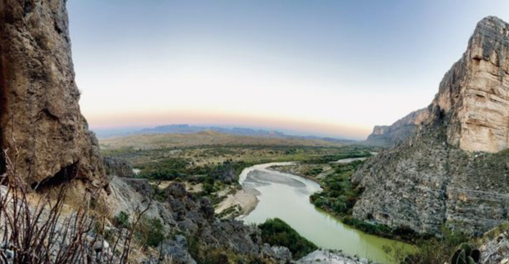
Texas stretches wider than most people can imagine, hiding pockets of natural wonder that make you wonder why anyone bothers traveling out of state. From canyons that glow at sunset to ghost towns frozen in time, these spots prove the Lone Star State holds more than dusty plains and urban sprawl. Some Texans guard these locations like family recipes, but beauty this stunning deserves to be shared with anyone willing to make the journey.
1. Lost Maples State Natural Area (Vanderpool)
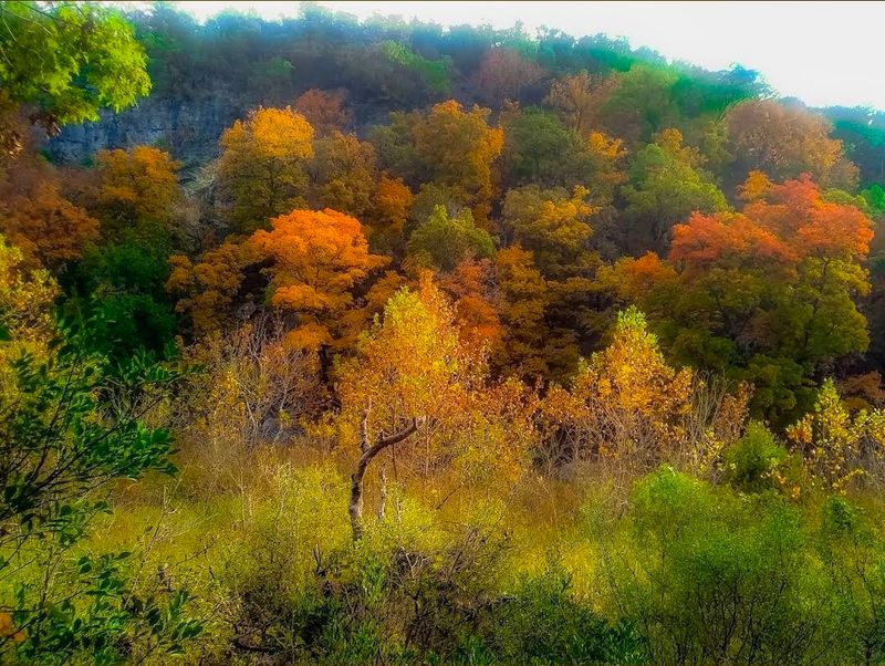
Most Texans don’t associate their state with fall colors, but this Hill Country gem flips that assumption on its head every autumn. Bigtooth maples blanket the canyons in shades of crimson, orange, and gold that rival anything New England offers. The transformation typically peaks in late October through early November, though exact timing shifts with weather patterns each year.
Five miles of trails wind through limestone hills and alongside the Sabinal River, offering routes for casual strollers and serious hikers alike. The East Trail climbs to overlooks where you can see waves of color rolling across the canyon below. Spring brings a different kind of magic, with wildflowers carpeting the grasslands and water flowing strong through the creeks.
Weekends during peak color season get packed, so arriving on weekdays or camping overnight gives you breathing room to enjoy the scenery. The park limits daily visitors to protect the fragile ecosystem, which means planning ahead isn’t optional if you want guaranteed entry. Primitive camping sites nestle among the trees, letting you wake up to bird calls and morning light filtering through the canopy.
Summer heat makes hiking less pleasant, but the swimming hole near the trailhead offers relief when temperatures climb. Wildlife sightings happen year-round, with white-tailed deer browsing near the trails and golden-cheeked warblers singing from the branches. The park sits about 70 miles west of San Antonio, making it an easy day trip or weekend escape.
Photography enthusiasts should bring wide-angle lenses to capture the full sweep of color across the canyons. Morning light hits the east-facing slopes first, creating dramatic contrasts between sunlit maples and shadowed limestone. The combination of geological features and botanical uniqueness makes this spot feel more like a secret garden than a state park, even when other visitors share the trails with you.
2. Marfa (Presidio County)
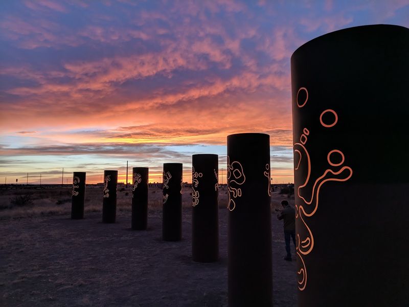
Out in the high desert where cell service gets spotty and the nearest city sits hours away, an art scene thrives that draws visitors from across the globe. What started as one artist’s vision in the 1970s has grown into a cultural phenomenon that somehow feels perfectly at home among ranches and tumbleweeds. Donald Judd’s concrete boxes scattered across the landscape create an outdoor gallery where art and nature blur together under endless West Texas skies.
The Chinati Foundation campus sprawls across former military buildings, housing massive installations that challenge conventional ideas about what art should be. Tours run year-round, though summer heat can make the warehouse visits feel like endurance tests. The town itself mixes cowboy culture with gallery openings, where you might see ranchers and art collectors sharing counter space at the same diner.
Prada Marfa, the fake storefront sitting alone on Highway 90, has become an Instagram landmark despite being miles from actual Marfa. The installation comments on consumerism and isolation, though most visitors just want the perfect photo. Mystery lights appear on Mitchell Flat east of town, drawing curious viewers who hope to witness the unexplained phenomenon that’s been reported since the 1880s.
Hotel Saint George anchors the downtown scene with its pool, restaurant, and rooms that balance minimalist design with actual comfort. Food Shark serves Mediterranean fare from a trailer, proving that quality doesn’t require fancy settings. Bookstores, vintage shops, and coffee houses fill the historic buildings, creating a walkable downtown that rewards slow exploration.
The landscape itself deserves as much attention as the art installations, with mountain ranges rising in the distance and desert flora creating subtle color shifts throughout the seasons. Sunrise and sunset paint the sky in colors that seem almost artificial, while nighttime reveals stars in quantities that city dwellers forget exist. The combination of cultural sophistication and raw wilderness creates a contrast that defines the Marfa experience.
3. Hamilton Pool Preserve (Dripping Springs)
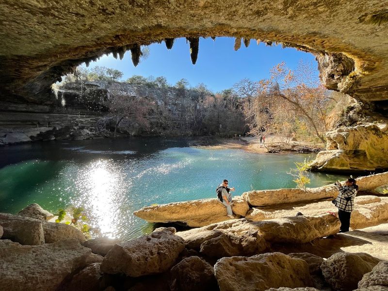
A collapsed grotto ceiling thousands of years ago created one of Texas’s most photographed swimming holes, where a 50-foot waterfall spills over limestone into jade-colored water. Stalactites cling to the overhang above, dripping with moss and ferns that thrive in the constant mist. The pool sits at the bottom of a canyon carved by natural erosion, accessible via a quarter-mile trail that descends through juniper and oak trees.
Reservations became mandatory after social media turned this hidden spot into a bucket-list destination for millions. The preserve limits daily visitors to 75 vehicles, with slots booking up weeks in advance during summer months. Swimming depends on water quality testing, which can close the pool after heavy rains when bacteria levels spike.
The hike down isn’t difficult, but the rocky trail and stairs require decent mobility and proper footwear. Arriving early in the morning lets you experience the grotto in soft light before crowds gather for midday visits. Winter visits offer solitude and dramatic icicles hanging from the overhang, though swimming in 60-degree water appeals to only the hardiest souls.
Travis Audubon Society manages the preserve, balancing public access with habitat protection for the golden-cheeked warbler and other species. The parking area includes restrooms and a small visitor center, but no food or drinks are sold on-site. Bringing water and snacks makes sense, especially in summer when temperatures regularly exceed 95 degrees.
Hamilton Creek flows year-round thanks to underground springs, though the waterfall’s volume varies with rainfall patterns. Drought years reduce the cascade to a trickle, while wet seasons create a thundering curtain of water. The grotto stays roughly 15 degrees cooler than the surrounding area, making it a natural air-conditioned refuge.
Photography restrictions don’t exist, so tripods and professional equipment are welcome as long as they don’t block pathways. The combination of geological drama and lush vegetation creates scenes that look almost tropical, a surprise for anyone expecting typical Texas scrubland.
4. Palo Duro Canyon State Park (Canyon)
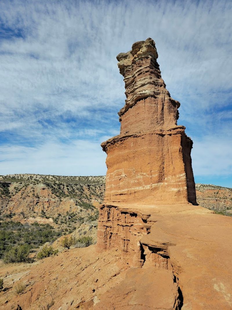
The second-largest canyon system in the United States hides in the Texas Panhandle, where most travelers zoom past on Interstate 40 without realizing what lies just miles away. Layers of red, orange, and white rock tell 250 million years of geological history, carved by the Prairie Dog Town Fork of the Red River. Spanish explorers named it Palo Duro, meaning hardwood, after discovering juniper trees growing along the canyon floor.
More than 30 miles of trails crisscross the canyon, ranging from easy valley walks to challenging rim climbs that gain over 500 feet in elevation. The Lighthouse Trail leads to the park’s signature rock formation, a hoodoo that stands like a beacon against the sky. Early morning starts help you beat the heat and catch the rock layers glowing in horizontal light that brings out every color variation.
A 16-mile scenic drive winds along the canyon floor, with pullouts at key viewpoints and trailheads. Mountain biking is permitted on several trails, and equestrian routes let riders explore backcountry areas closed to hikers. The park offers everything from primitive campsites to cabins with air conditioning, though booking ahead is essential during spring and fall peak seasons.
Summer temperatures regularly hit triple digits, making early morning and evening the only comfortable times for outdoor activities. Winter brings occasional snow that transforms the red rocks into something from a fantasy novel, with far fewer visitors to share the views. The outdoor musical Texas runs in the canyon during summer months, using the natural amphitheater as its stage.
Wildlife sightings include roadrunners, mule deer, and wild turkeys, with golden eagles soaring overhead on thermal currents. The canyon ecosystem supports species found nowhere else in Texas, adapted to the unique microclimate created by the 800-foot-deep gorge. Wildflowers bloom in waves from March through October, adding splashes of yellow, purple, and red to the already colorful landscape.
Stargazing after dark reveals the Milky Way stretching across the sky, undimmed by city lights that plague most of Texas.
5. Gruene Historic District (New Braunfels)
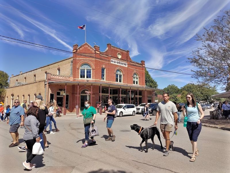
Frozen in time since its cotton-farming heyday ended in the 1920s, this tiny district preserves Texas Hill Country heritage without turning into a theme park. Original buildings house shops, restaurants, and Texas’s oldest operating dance hall, where legends like Willie Nelson and George Strait have played to crowds packed onto the worn wooden floor. The Guadalupe River flows past the district’s edge, adding the sound of moving water to the already peaceful atmosphere.
Gruene Hall opened in 1878 and still books live music seven nights a week, from local acoustic acts to nationally touring artists. The building lacks air conditioning, staying true to its roots with screened windows and ceiling fans that barely disturb the summer heat. Dancing happens whether the floor is crowded or nearly empty, with couples two-stepping to whatever band takes the small stage.
Antique stores fill several historic structures, offering everything from authentic Texas memorabilia to overpriced junk that somehow still tempts buyers. The Gristmill Restaurant occupies the ruins of an old cotton gin, with multilevel outdoor seating that overlooks the river below. Weekends bring crowds that can make parking and restaurant waits frustrating, while weekday visits offer the relaxed pace that suits the district’s character.
Gruene sits just upstream from New Braunfels’s famous tubing scene, though the district itself maintains a quieter vibe focused on history rather than party rafts. Several outfitters operate from the area, renting tubes and shuttling groups to launch points upriver. The Guadalupe runs clear and cool, fed by springs that keep temperatures refreshing even during August heat waves.
Christmas transforms the district with lights strung between buildings and vendors selling seasonal crafts in the market days area. Summer brings its own magic when fireflies emerge at dusk, blinking among the live oaks that shade the streets. The combination of authentic preservation and active use keeps Gruene from feeling like a museum, with real businesses serving actual customers rather than just tourists checking boxes.
Walking the district takes maybe thirty minutes if you ignore the shops, but most visitors linger for hours.
6. Caddo Lake State Park (Karnack)
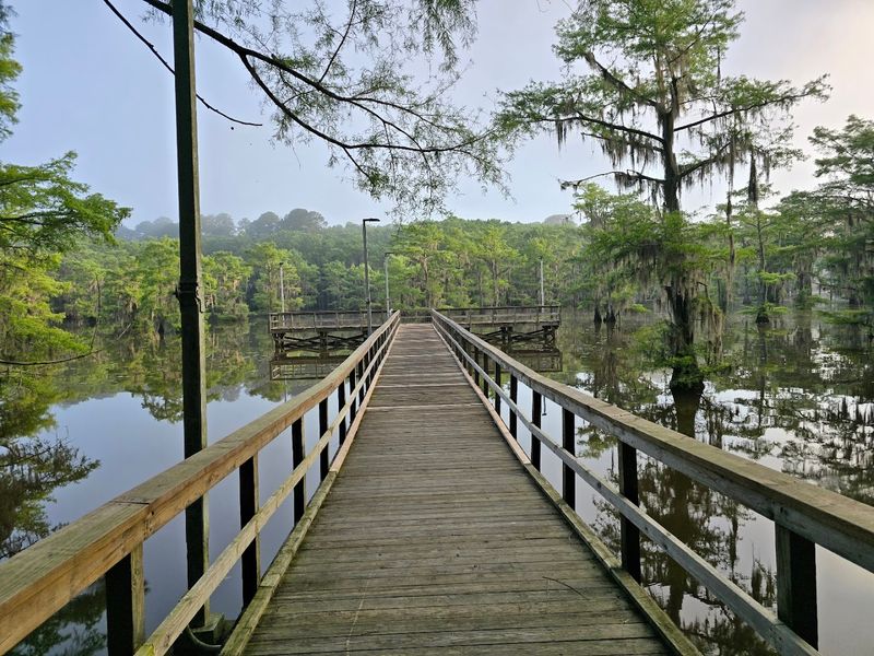
Spanish moss drapes from bald cypress trees rising out of dark water that mirrors the sky like obsidian glass. This isn’t Louisiana, despite appearances that suggest otherwise. The only natural lake in Texas spreads across 25,400 acres of waterways, sloughs, and bayous that create a maze best explored by kayak or canoe.
Cypress knees poke above the waterline like wooden stalagmites, and alligators sun themselves on logs when temperatures allow.
The park sits on the Texas side of a lake that straddles the Louisiana border, offering boat launches, paddling trails, and fishing spots that produce bass, catfish, and crappie. Marked paddling trails help prevent getting lost in the labyrinth of channels, though a GPS or good map remains essential for longer explorations. Renting a kayak or canoe from outfitters near the park makes sense for visitors without their own watercraft.
Cabins and campsites nestle among the pines, with screened shelters that let you sleep surrounded by night sounds without mosquito attacks. The lake’s water level fluctuates with dam operations and rainfall, sometimes exposing mudflats and other times flooding low-lying areas. Spring and fall offer the most pleasant conditions, with moderate temperatures and fewer biting insects than summer’s mosquito swarms.
Bird watching draws serious enthusiasts who come seeking species rarely found elsewhere in Texas, including prothonotary warblers that nest in the swamp. Fishing guides who know the lake’s secrets can lead you to productive spots hidden among the cypress stands. The ecosystem supports over 70 fish species and provides critical habitat for migratory waterfowl that stop during their seasonal journeys.
Sunrise on the lake creates scenes that photographers dream about, with fog rising off the water and light filtering through the moss-draped trees. The stillness before other boaters launch feels almost sacred, broken only by bird calls and the occasional fish jumping. History buffs appreciate that the lake formed when a massive logjam on the Red River created a natural dam centuries ago.
The mysterious atmosphere intensifies on overcast days when the water turns steel gray and shadows deepen under the cypress canopy.
7. Terlingua Ghost Town (Terlingua)
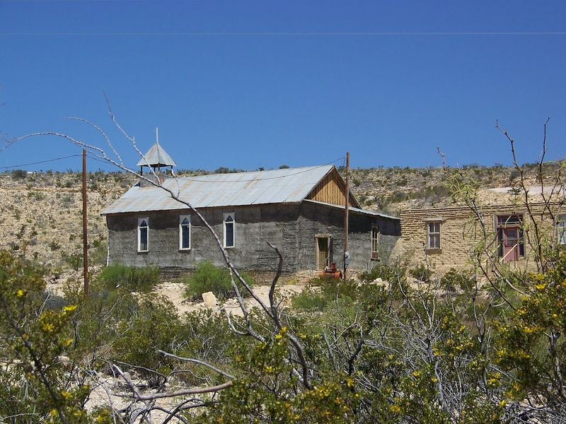
Crumbling adobe walls and rusted mining equipment scatter across the desert hillside where a mercury mining boom created a town that peaked at 2,000 residents in the early 1900s. When the mines played out and the company store closed in the 1940s, most people left for opportunities elsewhere. What remains is a collection of ruins, a few operating businesses, and a community of modern-day residents who embrace the remote location and quirky atmosphere.
The old cemetery sits on a hill overlooking the ruins, with weathered headstones marking graves of miners, children, and others who called this harsh landscape home. Perry Mansion, the former mine superintendent’s house, stands as the most photographed ruin, its roofless walls framing views of the Chisos Mountains in the distance. Wandering through the ghost town requires watching your step, as old mine shafts and unstable structures create genuine hazards.
Starlight Theatre, housed in a restored adobe building, serves food and hosts live music in a space that mixes historic character with functioning restaurant amenities. The annual Terlingua International Chili Championship draws thousands of competitors and spectators each November, temporarily transforming the ghost town into a crowded festival ground. La Kiva bar burrows underground like a cave, offering cold drinks and local color in equal measure.
Big Bend National Park’s western entrance sits just minutes away, making Terlingua a base camp for exploring the Chihuahuan Desert’s dramatic landscapes. The night sky here achieves darkness levels rarely experienced in modern America, with the Milky Way clearly visible and meteor showers putting on spectacular shows. Summer heat makes visiting brutal, with temperatures exceeding 100 degrees and little shade available among the ruins.
A small community of artists, river guides, and desert lovers maintains a permanent presence, operating galleries, tour companies, and lodging options that range from basic rooms to quirky rentals. The combination of authentic history and ongoing human presence keeps Terlingua from feeling like a preserved museum. Desert wildflowers bloom after rare rains, softening the harsh landscape with unexpected color.
Sunrise paints the ruins in golden light that emphasizes every texture in the weathered stone and adobe.
8. Enchanted Rock State Natural Area (Fredericksburg)
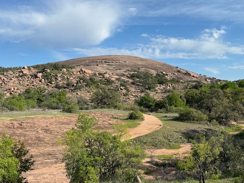
A pink granite dome rises 425 feet above the surrounding Hill Country, its bald summit visible for miles across the landscape. The rock itself is ancient, formed over a billion years ago when molten material cooled underground and later eroded to expose the massive batholith. Native American legends describe creaking and groaning sounds the rock makes at night as it cools and contracts, giving the formation its enchanted reputation.
The Summit Trail climbs directly up the dome’s face, gaining elevation quickly over bare rock that requires decent fitness and sturdy shoes. Reaching the top takes about an hour for average hikers, with the reward being 360-degree views that stretch to distant horizons. More than 11 miles of additional trails explore the park’s 1,644 acres, passing through oak groves, seasonal streams, and smaller granite formations.
Rock climbing routes cover various sections of the dome and surrounding outcrops, ranging from beginner-friendly to seriously challenging. Primitive camping is available in designated backcountry sites, though the park’s popularity means reservations book up weeks ahead for weekends. Day-use parking fills early on pleasant weather days, sometimes forcing the park to close to additional visitors by mid-morning.
Spring wildflowers carpet the areas around the rock’s base, with bluebonnets, Indian paintbrush, and other species creating colorful displays from March through May. Summer heat makes the exposed rock surface hot enough to cook on, while winter can bring freezing temperatures and occasional ice that makes the summit trail treacherous. Fall offers ideal hiking conditions with moderate temperatures and fewer crowds than spring.
Vernal pools form in depressions on the rock’s surface after rains, supporting unique ecosystems of fairy shrimp and other adapted species. The granite’s pink color intensifies at sunset, glowing against darkening skies in ways that justify countless photographs. Archaeological evidence shows human use of the site going back at least 12,000 years, with the rock serving as both landmark and gathering place.
Stargazing from the summit reveals constellations without light pollution, though overnight camping on top isn’t permitted.
9. Seminole Canyon State Park And Historic Site (Comstock)
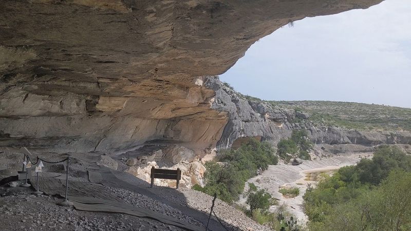
Four thousand years of human history covers the walls of rock shelters hidden in this remote canyon system northwest of Del Rio. Pictographs painted by ancient peoples depict shamanic figures, animals, and mysterious symbols in colors that have survived millennia protected under limestone overhangs. The park preserves some of the oldest and most significant rock art in North America, with guided tours providing the only legal access to the main pictograph sites.
Fate Bell Shelter contains the most impressive concentration of artwork, accessible via a guided hike that descends into the canyon along a sometimes challenging trail. Tours run Wednesday through Sunday when staff is available, with reservations recommended during cooler months when visitation peaks. The 90-minute tour covers both the art itself and the archaeology of the people who created it, adding context that transforms abstract images into windows on ancient cultures.
The canyon cuts through limestone layers deposited by ancient seas, creating cliffs and overhangs that provided shelter for nomadic hunter-gatherers. Springs once flowed year-round in the canyon bottom, supporting the wildlife and plant resources that sustained human occupation. Modern drought has reduced water flow, but the canyon still hosts a surprising diversity of desert-adapted species.
Camping facilities include sites with water and electric hookups, though the park’s remote location means limited cell service and no nearby towns for supplies. The park sits about 45 miles northwest of Del Rio, with the final approach on Highway 90 passing through classic West Texas desert landscape. Hiking trails beyond the guided tour routes let visitors explore the canyon rim and surrounding terrain independently.
Summer temperatures regularly exceed 100 degrees, making early morning the only comfortable time for outdoor activities. Winter brings mild days perfect for hiking, though overnight temperatures can drop below freezing. The night sky here achieves darkness levels that make stargazing spectacular, with the Milky Way clearly visible overhead.
The combination of cultural significance and natural beauty makes this park feel different from typical recreational areas. Standing before artwork created 4,000 years ago creates a connection across time that few experiences can match.
10. Gorman Falls At Colorado Bend State Park (Bend)
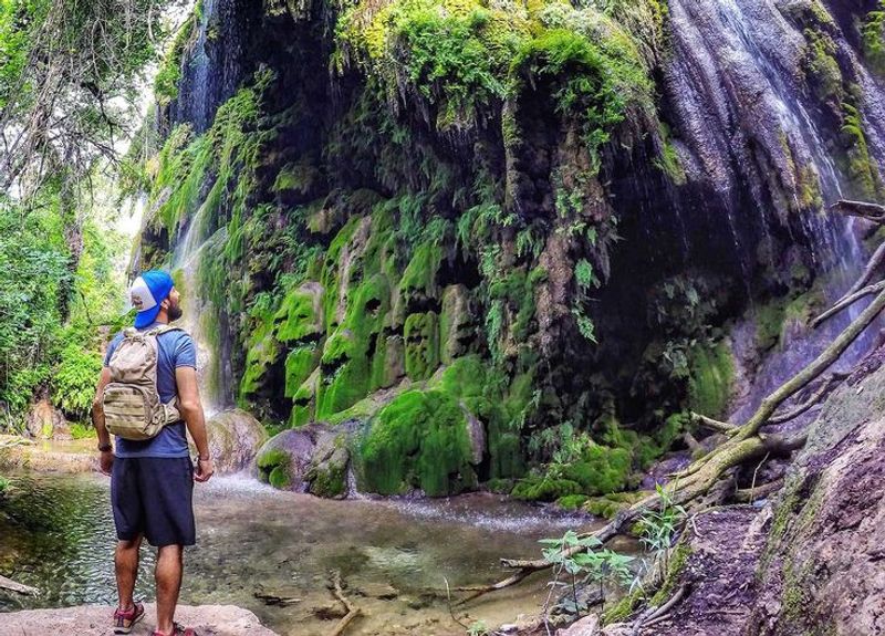
A 70-foot cascade of water spills over travertine formations covered in emerald moss and maidenhair ferns, creating a scene that belongs in a tropical rainforest rather than Central Texas. The falls form where mineral-rich spring water deposits calcium carbonate, building up layers of travertine that grow slowly over time. Moss, algae, and delicate ferns thrive in the constant spray, painting the formations in shades of green that contrast dramatically with the surrounding limestone canyon.
Reaching the falls requires a 3-mile hike each way on trails that cross the Colorado River via a low-water crossing. When the river runs high, the crossing becomes impassable, closing access to the falls until water levels drop. The trail itself winds through juniper and oak woodlands before descending into the canyon where Gorman Creek flows toward its junction with the river.
The park limits access to protect the fragile travertine formations and the rare species that depend on this unique ecosystem. Visitors must stay on marked viewing areas rather than climbing on the falls themselves, as human contact damages the delicate moss and disrupts the mineral deposition process. Photography from the viewing platform captures the falls beautifully, especially in morning light when the sun illuminates the cascading water.
Colorado Bend State Park encompasses over 5,300 acres of rugged Hill Country terrain, with more than 30 miles of trails for hiking and mountain biking. Cave tours explore underground passages decorated with formations, offered on weekends when trained guides are available. The park’s remote location and limited development preserve a wilderness character increasingly rare in Texas state parks.
Spring brings the highest water flow over the falls, creating a thundering display that contrasts with summer’s reduced trickle. Wildflowers bloom throughout the park in March and April, adding color to the already scenic landscape. The primitive camping areas lack modern amenities but offer solitude and dark skies for stargazing.
Getting to the park involves driving on several miles of unpaved roads that can become impassable during wet weather. The effort required to reach Gorman Falls filters out casual visitors, ensuring that those who make the journey find the scene relatively uncrowded.
11. Santa Elena Canyon (Big Bend National Park)
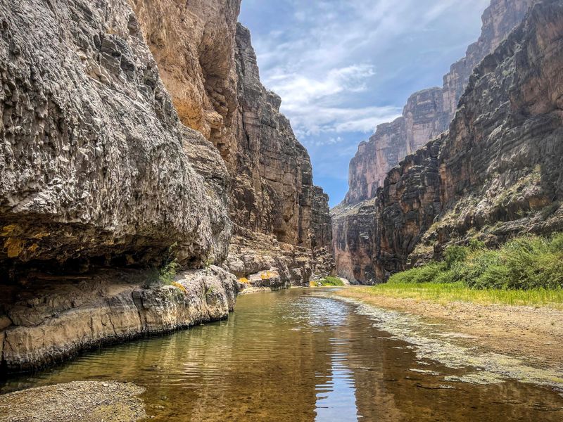
Sheer limestone cliffs rise 1,500 feet on either side of the Rio Grande, creating a canyon so narrow and deep that sunlight only reaches the river for a few hours each day. The walls glow in horizontal bands of cream, tan, and rust, each layer representing millions of years of sediment deposited when ancient seas covered this region. Standing at the canyon’s entrance, you feel the scale in your bones as the walls tower overhead, dwarfing everything human.
A trail follows the river into the canyon’s mouth, crossing a shallow creek before climbing onto a concrete path that hugs the cliff base. The 1.7-mile round trip offers constantly changing perspectives as you move deeper into the canyon, with the walls seeming to close in overhead. The river flows green and surprisingly clear, though flash flood debris lodged high on the canyon walls proves the power water can unleash.
Kayakers and canoeists can float through the entire 7.5-mile canyon when water levels permit, experiencing the full drama of the walls rising directly from the water’s edge. The float requires proper equipment and planning, as rapids and the remote location create genuine hazards for unprepared paddlers. Outfitters in the area offer guided trips for those lacking experience or equipment.
Morning light hits the canyon first, painting the Mexican side in warm tones while the Texas wall remains in shadow. Late afternoon reverses the pattern, with the western wall glowing as the eastern side darkens. The temperature inside the canyon stays noticeably cooler than the surrounding desert, making it a refuge during summer heat.
The canyon marks the border between Texas and Mexico, with the river serving as the international boundary. Looking up at the walls from the trail, you see both countries simultaneously, though the rock formations care nothing for political divisions. Desert bighorn sheep occasionally appear on the cliff faces, their sure-footedness on vertical terrain seeming impossible from below.
Big Bend’s remote location means this spectacular canyon sees fewer visitors than famous sites in other parks, despite scenery that rivals anything in the Southwest.
Share this story