North Carolina is quietly one of the best hiking states in the country, with trails that range from easy waterfall walks to rugged mountain routes deep in the Appalachians. The scenery shifts constantly, giving hikers everything from grassy balds and Blue Ridge overlooks to dense forests, river gorges, and mist-covered peaks in a single state.
Whether you are brand new to hiking or already chasing difficult summit climbs, there is a trail here capable of completely stopping you in your tracks. This ranked list moves from beginner-friendly favorites to demanding backcountry adventures that require real preparation, endurance, and grit. If your boots have been waiting for an excuse, this is it.
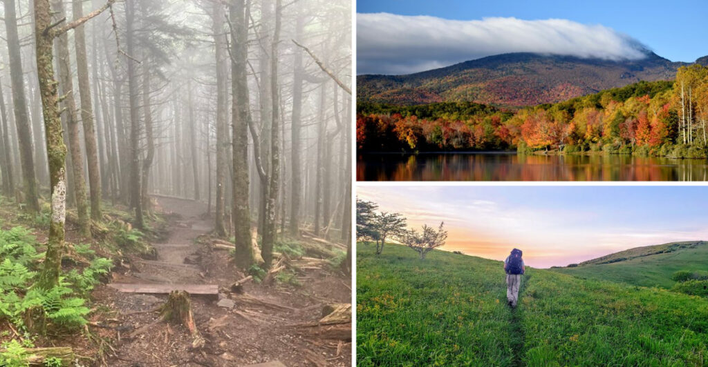
1. Price Lake Trail (Blowing Rock)
")
Some hikes earn their place on a bucket list not because they are hard, but because they are simply beautiful. Price Lake Trail in Blowing Rock is exactly that kind of hike.
Wrapping around a calm, mirror-like lake nestled in the mountains, this gentle loop feels more like a moving meditation than a workout.
The trail is mostly flat, making it one of the most accessible hikes in the entire state. Wooden boardwalks carry you over marshy sections near the water, and the surrounding forest stays lush and shaded for most of the route.
Families with young kids, older hikers looking for a low-impact outing, and first-timers who want to build confidence will all find this trail welcoming.
What makes the scenery pop here is the reflection of the tree line on the lake surface, especially during fall when the leaves turn gold and orange. Wildlife sightings are common too, with herons, turtles, and the occasional deer making appearances along the water’s edge.
Located right along the Blue Ridge Parkway near milepost 297, the trailhead is easy to find and the parking area is well-maintained. The full loop clocks in at just under 2.5 miles, which most people finish comfortably in under an hour and a half.
Pack a small snack, bring a camera, and take your time soaking in the quiet. Price Lake Trail proves that not every great hike needs to leave you breathless from exertion.
2. Bearwallow Mountain Trail (Hendersonville)
")
Not every rewarding hike demands an all-day commitment. Bearwallow Mountain Trail near Hendersonville delivers one of the most satisfying summit payoffs in western North Carolina without asking too much of your legs.
The climb is short, the views are massive, and the whole experience feels like a well-kept local secret. The trail gains around 1,000 feet of elevation over roughly 2 miles, which gives it enough of a workout feel to make reaching the top genuinely satisfying.
Once you break through the tree line near the summit, a wide, open meadow spreads out in front of you. The grassy bald at the top offers unobstructed 360-degree views of the Blue Ridge Mountains, farmland valleys, and rolling ridgelines stretching in every direction.
Spring and early summer bring wildflowers to the meadow, while fall turns the surrounding forest into a patchwork of warm colors. The trail passes through a working cattle farm on the lower section, so it is not uncommon to share the path with grazing cows, which adds a surprisingly charming rural character to the hike.
Trailhead parking is available at a small lot off Bear Wallow Road, and the path is well-marked throughout. Dogs are welcome on leash, making this a popular weekend outing for pet owners.
Plan to arrive early on weekends to snag a parking spot. Bearwallow is proof that a short hike and a spectacular view are not mutually exclusive.
3. Glen Burney Trail (Blowing Rock)
")
Hidden just minutes from downtown Blowing Rock, Glen Burney Trail feels like stepping into a completely different world.
The moment you head down into the gorge, the noise of town fades out and all you hear is rushing water and birdsong. Few trails in the High Country pack this much atmosphere into such a short distance.
The route descends through dense woodland, following a creek that grows louder and more dramatic as you move deeper into the gorge. Stone stairways guide you past mossy boulders and over small wooden bridges, and the footing stays manageable for most of the descent.
Two main waterfalls, Glen Burney Falls and Glen Marie Falls, reward hikers who make it to the lower sections of the trail.
Because it is a descent-heavy trail, the return trip back up is where you will feel the burn. The elevation change is moderate but noticeable, so wearing proper footwear with grip is a smart move, especially after rain when the stone steps get slippery.
The trail is roughly 2 miles round trip, making it a great choice for a morning outing before heading into town for lunch.
Access starts at Annie Cannon Park in Blowing Rock, which keeps the trailhead easy to reach without needing a long drive.
The cool, shaded atmosphere makes this hike particularly refreshing during summer when mountain temperatures are already mild. Glen Burney Trail rewards curiosity with scenery that genuinely feels hidden and earned.
4. Linville Falls Trail (Linville Gorge)
")
Linville Falls might be the most photographed waterfall in North Carolina, and once you see it in person, the reason becomes immediately obvious.
The water drops in two powerful stages into one of the deepest gorges in the eastern United States, creating a scene that is equal parts thunderous and beautiful. Standing at any of the overlooks here feels genuinely cinematic.
The trail system around Linville Falls offers multiple routes ranging from a quick half-mile walk to a more involved 1.6-mile loop with several distinct viewpoints.
The Erwin’s View Trail is the most popular option, leading hikers through rhododendron tunnels and across wooden bridges before opening onto dramatic cliff-edge overlooks above the gorge. Each overlook offers a slightly different perspective on the falls and the rugged canyon below.
The terrain is well-maintained and suitable for most fitness levels, though some sections near the overlooks involve uneven rocky ground that calls for careful footing. The falls are impressive year-round, but late winter and early spring bring peak water flow that turns the cascade into something truly thunderous.
The trailhead sits just off the Blue Ridge Parkway near milepost 316, with a staffed visitor center and restrooms available nearby. Parking fills up fast on weekends between June and October, so arriving before 9 a.m. is strongly recommended.
Linville Falls Trail earns its spot on any North Carolina hiking list by delivering world-class scenery without requiring world-class fitness.
5. Black Balsam Knob via Ivestor Gap Trail (Pisgah National Forest)
")
Once the trail breaks out of the forest, the whole world opens up. Black Balsam Knob via the Ivestor Gap Trail is one of those rare hikes where the summit experience begins well before you actually reach the top.
The trail crosses open, grassy balds for much of its length, meaning the views start early and just keep getting better.
Starting from the Art Loeb Trailhead off the Blue Ridge Parkway, the path climbs steadily through high-elevation terrain with surprisingly minimal tree cover.
The exposed ridgeline walking feels almost alpine, with cool breezes and sweeping vistas that stretch across layer after layer of blue mountain ridges. On clear days, the visibility seems almost endless.
The hike to Black Balsam Knob is roughly 3.5 miles round trip with around 600 feet of elevation gain, putting it comfortably in the moderate category. The trail surface is rocky in places and can be muddy after rain, so sturdy footwear is worth the investment.
Because the terrain is so exposed, afternoon thunderstorms can roll in quickly during summer, making an early morning start both safer and more scenic.
Fall is particularly spectacular here, when the surrounding forest turns and the high-elevation grasses take on golden tones. Sunrise hikes from this summit have earned near-legendary status among photographers and outdoor enthusiasts across the region.
Black Balsam Knob gives you the feeling of standing on top of the world without requiring technical climbing skills or a multi-day commitment.
6. Looking Glass Rock Trail (Pisgah National Forest)
")
There is something almost mythical about a mountain made entirely of granite. Looking Glass Rock earns its name from the way its smooth, curved face catches the winter light and shimmers like a giant mirror visible for miles across Pisgah National Forest.
Getting to the top of it is a hike that rewards every step of effort with views that feel genuinely hard to believe. The trail climbs steadily from the trailhead near the Davidson River Campground, gaining roughly 1,700 feet over about 3 miles of uphill hiking.
The path winds through dense hardwood and hemlock forest, keeping things shaded and cool even during summer. As you near the summit, the trees thin out and the massive granite dome begins to emerge around you.
Reaching the top means stepping onto one of the largest exposed granite faces in the eastern United States. The summit plateau offers sweeping views across Transylvania County, with the forest canopy spreading out below like a green quilt.
On clear days, the layers of distant ridges create a depth of scenery that is hard to capture in photographs. The descent follows the same route back down, which means tired legs on the return trip but also a chance to notice details you missed on the way up. Trekking poles are genuinely useful here, especially on the steeper sections.
Looking Glass Rock Trail consistently ranks among the top hikes in the entire state, and spending time on its summit makes it very easy to understand why.
7. Calloway Peak Out-and-Back (Grandfather Mountain State Park)
")
Grandfather Mountain still delivers a serious challenge, but the out-and-back hike to Calloway Peak offers a more approachable experience than tackling the mountain’s full ridge traverse.
While hikers will still encounter steep climbs, rocky terrain, and a few cable-assisted sections, this route focuses more on the rewarding summit journey than the most technical portions of the mountain.
The trail steadily climbs through dense spruce-fir forest before opening onto exposed sections with sweeping Blue Ridge views. As elevation builds, the scenery becomes increasingly dramatic, with layered mountain ridges stretching endlessly across the horizon.
Reaching Calloway Peak, the highest point on Grandfather Mountain at 5,946 feet, feels like a genuine accomplishment without requiring the full commitment and exposure of the complete traverse.
Some portions of the route still demand careful footing, especially after rain when rocks become slippery, but most experienced hikers in solid physical condition can complete the hike comfortably with preparation and patience.
The changing mountain weather also adds to the adventure, with cool winds and passing fog often creating an almost cinematic atmosphere near the summit. Good hiking boots, plenty of water, and layered clothing are strongly recommended for the climb.
Starting early is also smart, especially during warmer months when parking fills quickly and afternoon storms become more likely. For hikers looking to experience Grandfather Mountain’s iconic scenery without committing to its toughest full-ridge challenge, the Calloway Peak out-and-back strikes an ideal balance between adventure and accessibility.
8. Mount Mitchell Trail (Black Mountain)
")
Standing at 6,684 feet, Mount Mitchell holds the title of the highest peak east of the Mississippi River. That alone makes the Mount Mitchell Trail one of the most significant hikes in the eastern United States.
But the experience of actually climbing it under your own power, through forests that feel more like the Canadian wilderness than the American South, is what makes it truly unforgettable.
The Mount Mitchell Trail begins at Black Mountain Campground and climbs roughly 3,600 feet over about 5.6 miles, making it a serious physical undertaking.
The route passes through several distinct ecological zones as elevation increases, transitioning from hardwood forest into the dense, fog-wrapped spruce-fir forest that defines the upper mountain.
The air gets noticeably cooler and damper as you climb, and the landscape takes on an almost otherworldly quality near the summit.
Unlike driving to the summit via the state park road, earning the top on foot gives you a completely different relationship with the mountain. The physical effort sharpens your appreciation for every foot of elevation gained, and arriving at the summit tower after a full day of climbing carries a weight that a car ride simply cannot replicate.
Start early to avoid afternoon weather, carry more water than you think you need, and plan for a long day on the trail. The descent back down is knee-intensive, so trekking poles are highly recommended. Mount Mitchell Trail is not a casual outing, but it is absolutely one worth putting on the list.
9. Roan Mountain Section of the Appalachian Trail (Roan Highlands)
")
Few places along the entire Appalachian Trail feel as wide open and otherworldly as the Roan Highlands. The grassy balds here, including Roan High Bluff, Roan High Knob, and the famous Hump Mountain section, offer a ridge-walking experience that feels completely different from anything else in the Southeast.
The sky seems bigger up here, and the sense of exposure is both humbling and exhilarating. The Roan Mountain section of the AT covers a stretch of trail connecting North Carolina and Tennessee, with the most popular day-hiking segments running through the Carvers Gap area.
From the parking area at Carvers Gap, hikers can head in either direction along the ridge, with the round trip to Hump Mountain covering roughly 8 miles with significant elevation change along the way.
Late June brings one of the most spectacular natural events in the Appalachians: the blooming of catawba rhododendrons across the balds and surrounding forest.
The explosion of purple and pink color against the green grassy ridges draws hikers from across the region and creates a scene that is almost surreal in its beauty.
Wind exposure is a constant factor on the balds, so even on warm summer days, bringing a wind layer is smart. The terrain is demanding enough that solid hiking footwear and a good pace strategy matter, especially on longer out-and-back routes.
The Roan Highlands section of the AT delivers a ridge-hiking experience that stays with you long after the trail is behind you.
10. Shining Rock Wilderness via Art Loeb Trail (Pisgah National Forest)
")
Shining Rock Wilderness gets its name from the massive quartz outcroppings that dot its high-elevation summits, glittering in sunlight like scattered diamonds across the mountain.
Accessing this remote wilderness area via the Art Loeb Trail puts you deep into some of the most rugged and visually striking terrain in all of western North Carolina.
The route from the Cold Mountain Trailhead or the Black Balsam Knob area covers serious mileage with significant elevation change, making this a hike best suited for experienced day hikers or backpackers comfortable with multi-mile wilderness travel.
The Art Loeb Trail connects several high peaks and open balds before reaching the glittering white summit of Shining Rock itself, which sits at around 6,000 feet elevation.
Navigation requires attention here, as the wilderness area has limited signage by design, and trails can be harder to follow in poor visibility or after snow.
Carrying a map and compass, or a reliable GPS device, is strongly recommended for anyone venturing deep into the wilderness. The solitude and wildness of the area are part of its appeal, but they also demand respect and preparation.
Camping is permitted throughout the wilderness area, making this an excellent backpacking destination for those who want to experience the mountains at a slower pace. The quartz summit glows at sunrise with an almost magical quality that rewards early risers who camp nearby.
Shining Rock Wilderness via the Art Loeb Trail is the kind of place that resets your perspective on what wild really means.
11. Slickrock Creek Trail (Nantahala National Forest)
")
Slickrock Creek Trail has a reputation that precedes it among serious hikers in the Southeast. Tucked deep within the Joyce Kilmer-Slickrock Wilderness in Nantahala National Forest, this trail is relentlessly demanding from start to finish, combining steep elevation changes, rocky and rooted footing, and multiple creek crossings that require careful navigation regardless of water levels.
The full Slickrock Creek loop covers around 13 miles of genuinely tough terrain, with cumulative elevation gain that adds up quickly across the rolling backcountry.
The trail follows Slickrock Creek for much of its length, passing through old-growth forest that has never been logged, giving the landscape a primeval quality that feels completely removed from the modern world.
Creek crossings are the wildcard here. After heavy rainfall, some crossings become significantly more challenging, and the rocky creek beds require solid footing and careful step selection.
Waterproof boots or trail shoes with reliable grip are essential, and hiking poles provide meaningful stability on the more technical sections of the route.
Because the trail is remote and the terrain is unforgiving, this is not a hike to attempt without solid backcountry experience, proper gear, and a well-thought-out plan.
Cell service is essentially nonexistent in the wilderness area, so filing a trip plan with someone reliable before heading out is a smart safety habit.
Slickrock Creek Trail rewards those who are ready for it with a raw, untamed hiking experience that is genuinely hard to find anywhere else in North Carolina.
12. Art Loeb Trail (Pisgah National Forest)
")
Thirty miles of steep climbs, exposed balds, creek crossings, and constantly shifting mountain scenery — the Art Loeb Trail does not offer a single boring mile.
Named for a longtime leader of the Carolina Mountain Club, this legendary route runs from the Davidson River Campground to Daniel Boone Scout Camp near the community of Bethel, cutting through the heart of Pisgah National Forest along the way.
Most hikers tackle the Art Loeb Trail as a multi-day backpacking trip, breaking the route into sections and camping at designated sites along the way.
The trail crosses several notable high points, including Cold Mountain, which many North Carolina residents will recognize from Charles Frazier’s famous novel of the same name. Reaching that summit on foot carries a certain literary weight that adds to the experience.
The terrain varies dramatically over the course of the full route, moving from dense river valley forest to open grassy balds and back into deep woodland.
That variety keeps the scenery fresh over multiple days and gives the trail a narrative quality, as if the landscape is telling a story that unfolds mile by mile.
Proper trip planning matters enormously for a thru-hike of the Art Loeb Trail. Water sources need to be identified in advance, weather windows should be chosen carefully, and bear canisters or hang systems are required for food storage in the backcountry. The Art Loeb Trail is a true North Carolina classic that rewards hikers willing to put in the planning and the miles.
13. Mountains-to-Sea Trail (Across North Carolina)
")
Nearly 1,200 miles of trail connecting the mist-covered peaks of the Great Smoky Mountains to the windswept barrier islands of the Outer Banks — the Mountains-to-Sea Trail is less a single hike and more a lifetime’s worth of North Carolina adventure compressed into one continuous route.
Completing the entire trail is a serious long-distance undertaking, but the trail is also perfectly suited for section hiking over months or years.
The MST passes through an extraordinary range of landscapes, including high mountain balds, Piedmont forests, river floodplains, and coastal marshes. That ecological diversity makes every section feel distinct, as if the trail is constantly introducing you to a new version of North Carolina you had not yet met.
The western mountain sections are the most physically demanding, while the eastern sections offer a different kind of challenge in the form of heat, humidity, and long flat distances.
Logistics for a full thru-hike are complex, requiring careful planning around resupply points, water sources, and seasonal conditions across different regions of the state. The trail is maintained by the Friends of the Mountains-to-Sea Trail, which keeps the route well-marked with white circles on trees and posts throughout its entire length.
Even hiking just a small section of the MST delivers a meaningful taste of what makes North Carolina so remarkable as an outdoor destination.
The trail has a quiet, almost meditative quality that rewards patience and presence. The Mountains-to-Sea Trail is the ultimate expression of what North Carolina hiking can be.
14. Grandfather Trail Full Traverse (Grandfather Mountain State Park)
")
Going back to Grandfather Mountain is not repetition — it is respect. The full traverse of the Grandfather Trail, taken end to end rather than just as a summit push to Calloway Peak, represents one of the most technically demanding and thrilling ridge walks in the entire eastern United States.
Every section of this trail earns your attention. The complete traverse covers several miles of exposed ridgeline, crossing multiple peaks and exposed sections along the ridge.
Metal ladders bolted directly into cliff faces, fixed cable handholds on steep rocky sections, and narrow ledge traverses with serious exposure make this a route that demands both physical strength and a calm head for heights.
The consequence of a misstep in certain sections is real, which is why many experienced hikers consider this the ultimate challenge in North Carolina’s state park system.
Weather plays a massive role in the safety and enjoyment of the full traverse. Wet rock turns manageable scrambles into genuinely risky situations, and afternoon lightning storms can develop rapidly on the exposed ridge.
Starting at first light and moving efficiently through the most exposed sections before midday is standard practice for those who know the mountain well.
The payoff for all of that effort is a summit experience and a ridgeline traverse that has no equal in the state. The views from MacRae Peak and along the exposed spine of the mountain are absolutely staggering. Grandfather Mountain’s full trail traverse belongs at the very top of any serious North Carolina hiking list.