Set along the southern shore of Lake Superior, Pictured Rocks National Lakeshore is one of Michigan’s most awe-inspiring natural treasures. A scenic route stretches between the charming towns of Munising and Grand Marais, placing you in the middle of soaring sandstone cliffs, tucked-away waterfalls, and sparkling clear waters.
It’s the kind of drive that tempts you to stop every few miles just to take it all in. Whether you’re visiting for the first time or making your way back to a favorite corner of the Upper Peninsula, this route offers something memorable around every bend.
Munising: Your Gateway to the Adventure

Munising doesn’t just sit at the edge of Pictured Rocks — it practically rolls out the welcome mat for every visitor heading into the lakeshore. This small Upper Peninsula town has a surprisingly lively personality, packed with local restaurants, outfitter shops, kayak rentals, and boat tour companies that make it easy to jump right into adventure mode.
The waterfront area gives you your first real look at Lake Superior, and trust us, that first glimpse hits differently.
Parking is easy to find, and the locals are genuinely happy to point you in the right direction. Many visitors spend their first evening here grabbing a pasty — a classic UP meat-filled pastry — before planning the next day’s route into the park.
The town has just enough amenities to keep you comfortable without feeling like you’ve traded nature for a resort.
Munising also serves as the launch point for the incredibly popular Pictured Rocks Cruises, which take you right up alongside the colorful sandstone cliffs from the water. Booking those tickets in town the night before is a smart move, especially in peak summer season when spots fill fast.
The Munising Visitor Center on the main strip is a solid first stop where rangers can help you map out hiking trails, waterfall routes, and camping spots inside the lakeshore. Grab a free park map and a cup of coffee, and you’re already ahead of the game.
This town punches way above its weight when it comes to setting up an incredible outdoor experience, and it earns its title as the true gateway to one of Michigan’s greatest national parks.
The Sandstone Cliffs That Steal Every Show

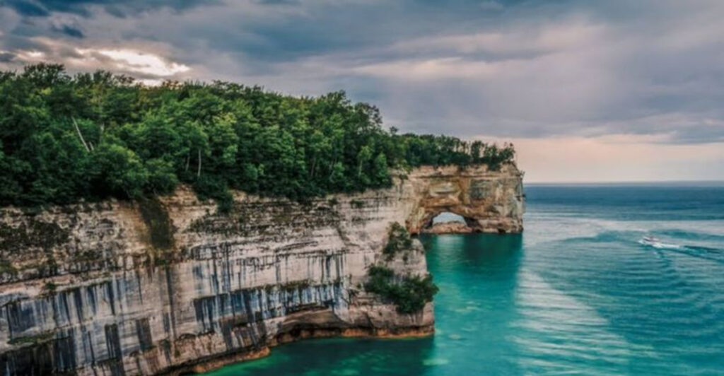
Nothing quite prepares you for the moment you first see the cliffs of Pictured Rocks. Stretching for roughly 15 miles along Lake Superior’s shoreline, these sandstone formations rise up to 200 feet above the water, streaked with bold bands of copper, iron, and manganese that paint them in shades of red, orange, pink, and green.
It’s the kind of color show that makes people stop mid-sentence just to stare.
The cliffs get their name from those vivid mineral streaks, which have been seeping through the rock and staining the surface for thousands of years. Formations like Miners Castle, Chapel Rock, and Battleship Row each have their own distinct shapes and personalities.
Miners Castle is probably the most photographed spot in the entire park, and for good reason — the two turret-like rock formations jutting out over the lake look like something straight out of a fantasy novel.
Seeing the cliffs from the water on a boat tour gives you a perspective that no trail can match. The way the light hits those mineral stains in the afternoon turns the cliffs into something almost unreal, like a living watercolor painting.
For hikers, the North Country Trail runs along the top of the cliffs and offers dramatic overlooks that will absolutely test your nerve if you’re not a fan of heights. The combination of the deep blue lake below and the towering painted rock above creates a visual contrast that photographers chase from all over the country.
Visiting in late September adds golden and crimson foliage to the mix, making the whole scene feel even more theatrical. These cliffs are the undeniable star of the entire route.
Miners Beach and the Magic of Lake Superior Up Close

Miners Beach is one of those places that genuinely surprises people who’ve never been to the Upper Peninsula before. The water here is so clear and so intensely blue that visitors often do a double take, wondering if they’ve somehow wandered onto a Caribbean island instead of a Michigan lakeshore.
Lake Superior’s cold temperatures keep the water looking almost impossibly vivid, especially on a sunny summer afternoon.
Getting to Miners Beach involves a short but scenic walk through a forested trail from the Miners Beach parking area, which is just off Miners Castle Road inside the park. The walk takes maybe 10 to 15 minutes and winds through tall pines before opening up to a wide, sandy shoreline.
It’s a moment that earns serious gasps from first-timers every single time.
The beach itself is wide and open, with enough room to spread out even on a busy weekend. Swimming is allowed, though the water stays cold enough to make most people wade rather than swim laps.
Nearby, Miners River flows into the lake, creating a fun shallow area where kids absolutely love to splash around. The beach sits just below Miners Castle overlook, so you can hike up to the famous viewpoint and then come back down to relax on the sand — a perfect one-two punch for a morning in the park.
Sunsets here are genuinely spectacular, painting the sky in shades of orange and purple while the cliffs glow in the fading light. Pack a picnic, bring a blanket, and plan to stay longer than you think you will.
Miners Beach has a way of making time disappear in the best possible way.
Chapel Falls: A Waterfall Worth Every Step

There’s a reason Chapel Falls shows up on practically every Upper Peninsula bucket list. This stunning waterfall drops about 60 feet into a rocky gorge surrounded by dense forest, and the trail leading to it is one of the most rewarding moderate hikes in the entire park.
The round trip from the Chapel Falls trailhead runs about 10 miles if you include Chapel Rock and Chapel Beach, but you can always turn around at the falls for a shorter outing.
The trail itself winds through mixed hardwood and pine forest, crossing small streams and offering occasional peeks at the surrounding landscape. In spring and early summer, the falls run with impressive force thanks to snowmelt and rainfall, creating a thunderous roar you can hear well before you see the water.
Fall visits reward hikers with a fiery backdrop of maples and birches framing the cascade in orange and gold.
What makes Chapel Falls particularly special is the full loop option. Continuing past the falls takes you to Chapel Rock — a striking sandstone pillar with a lone pine tree somehow growing from its top — and then down to Chapel Beach on the shores of Lake Superior.
Standing on that beach after a full morning of hiking, with the cliffs rising on one side and the open lake stretching to the horizon on the other, is a legitimately moving experience. The trailhead parking area can fill up quickly on summer weekends, so arriving early in the morning is a smart strategy.
Bring trekking poles if you have them, because some sections of the trail get muddy and uneven after rain. Chapel Falls is the kind of destination that turns a casual park visitor into a full-blown Upper Peninsula devotee.
The North Country Trail: Walking the Edge of the World

Spanning thousands of miles across multiple states, the North Country Trail is America’s longest National Scenic Trail — and its stretch through Pictured Rocks National Lakeshore might just be its most dramatic segment. The section running between Munising and Grand Marais covers roughly 42 miles and takes most backpackers between three and five days to complete.
Every mile of it delivers something worth stopping for.
Cliff-edge views, secluded beach camps, towering dunes, and dense boreal forest all show up in rotation along this trail, keeping the experience fresh even over multiple days. Backcountry campsites are spread throughout the lakeshore, and permits are required for overnight stays — something worth booking well ahead of your trip, especially for summer weekends.
The permit system helps keep the trail from getting overcrowded, which means even peak season visitors can find genuine solitude out there.
Day hikers can jump onto the trail from several access points, including the popular Miners Castle trailhead and the Beaver Lake area. The section near Spray Falls — a waterfall that drops directly into Lake Superior — is considered one of the most dramatic short hikes in the entire park.
Watching that water fall straight into the big lake with no beach or rocks between them is a sight that sticks with you for years. Trail conditions can vary significantly depending on the season, with spring often bringing muddy patches and downed trees from winter storms.
Good waterproof boots are non-negotiable here. The North Country Trail through Pictured Rocks is the kind of experience that resets your perspective, reminding you just how wild and magnificent Michigan’s Upper Peninsula really is.
Grand Marais: The Quiet Town at the Other End

At the eastern end of Pictured Rocks National Lakeshore sits Grand Marais, a tiny harbor town with an outsized amount of charm. With a population that hovers around 300 people, this is the kind of place where everyone waves from their porch and the local tavern doubles as the community gathering spot.
After a few days of wilderness hiking, rolling into Grand Marais feels like finding civilization at just the right moment.
The town’s small harbor is genuinely picturesque, sheltered by a curved breakwater and watched over by a historic lighthouse that has guided ships since the late 1800s. Kayakers often paddle in from the lakeshore, pulling their boats up on the sandy beach near the harbor and wandering into town for a burger and a cold drink.
The whole scene has a slow, unhurried energy that’s increasingly rare to find anywhere.
Grand Marais also serves as the eastern trailhead for the North Country Trail through the lakeshore, making it the logical end point for multi-day backpacking trips coming from Munising. The Gitche Gumee Agate and History Museum is a quirky little gem worth a stop — agates pulled from Lake Superior’s shores are on display alongside local history exhibits that give real context to the region’s past.
The nearby Sable Falls and the Grand Sable Dunes, located just west of town inside the park boundary, are absolutely worth exploring before you leave the area. Those massive dunes rolling right up to the edge of Lake Superior create one of the most unexpected landscapes in all of Michigan.
Grand Marais is the kind of town that makes you bookmark it for a return trip before you’ve even left the parking lot.
Grand Sable Dunes: Sand, Sky, and Sheer Scale

Most people don’t expect to find towering sand dunes at the edge of a Great Lake, but the Upper Peninsula has a way of defying expectations at every turn. The Grand Sable Dunes near Grand Marais stretch for about five miles along the Lake Superior shoreline and rise as high as 275 feet above the water.
Standing on top of them and looking out over the vast expanse of Lake Superior is a genuinely humbling experience.
The dunes are perched above a steep bluff, and the combination of open sand, pine forest, and massive lake below creates a landscape that feels almost otherworldly. Climbing up the dunes from the beach requires real effort — the loose sand makes every step feel like two — but the view from the top is worth every burning calf muscle.
Coming down is a whole different story, and most people end up half-running, half-sliding in a way that brings out the kid in everyone.
The Grand Sable Dunes are accessible from the Log Slide Overlook, where a short trail leads to a dramatic viewpoint above the lake. Historically, logs were slid down this very slope to waiting ships below, giving the overlook its memorable name.
Just east of the dunes, Sable Falls drops through a series of sandstone steps into a forested ravine before reaching the lake — a gorgeous and relatively easy half-mile hike that pairs perfectly with a dunes visit. Parking at the Sable Falls trailhead fills up fast on summer afternoons, so morning visits are smarter.
The Grand Sable Dunes close out the Pictured Rocks experience with the same sense of scale and drama that defines the entire route from Munising, making them an absolutely essential final stop before heading home.