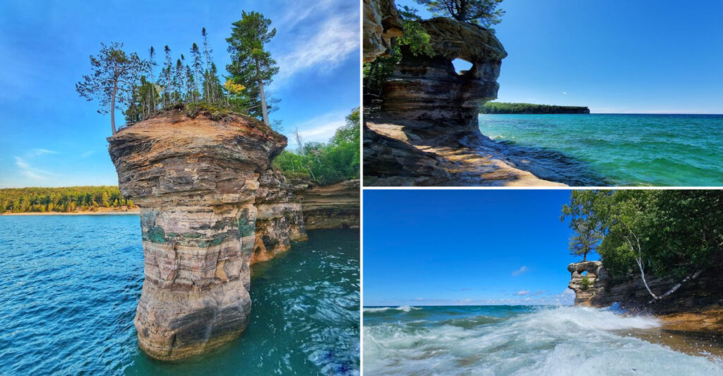
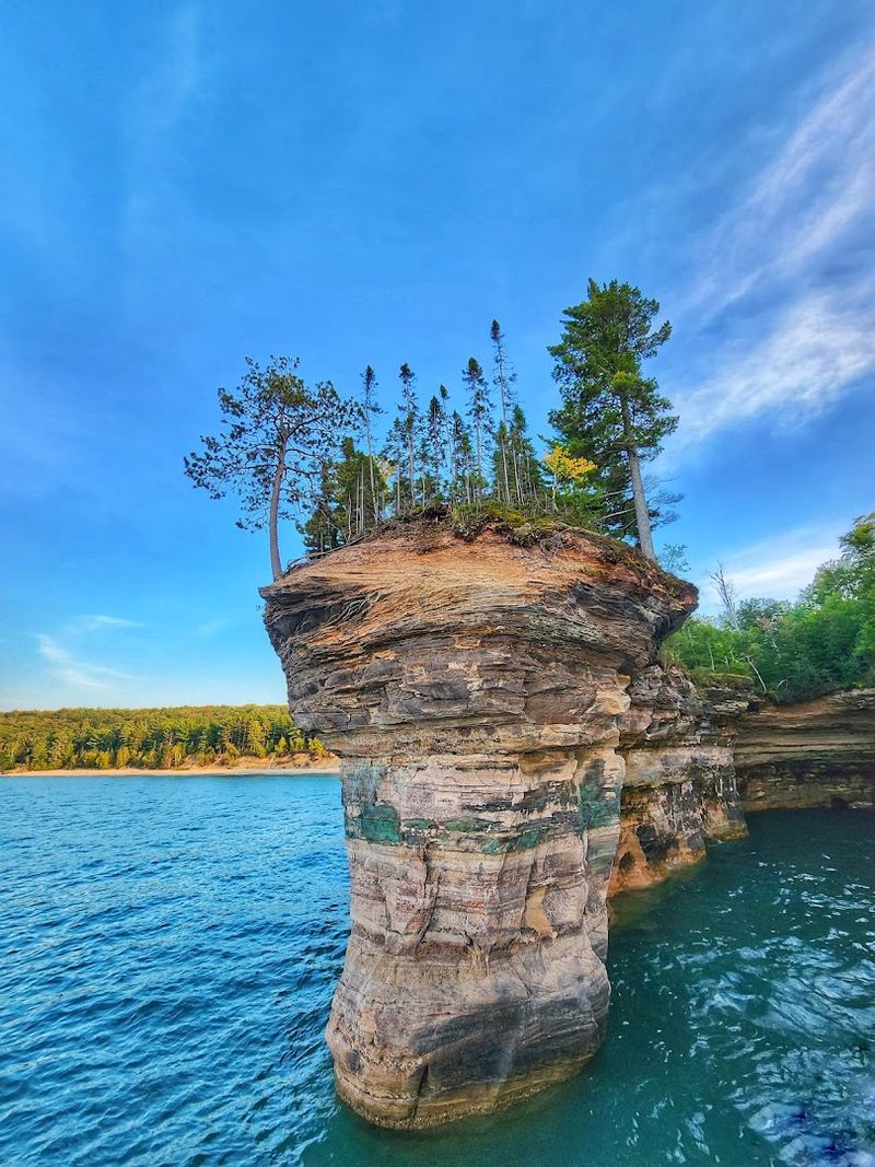
Standing tall above the cold, churning waters of Lake Superior, Chapel Rock is one of Michigan’s most striking natural landmarks. Carved over thousands of years by relentless waves, wind, and ice, this towering sandstone pillar looks almost like something out of a storybook.
A lone white pine clings to its top, roots stretching dramatically across a gap to the mainland cliff, making it one of the most photographed formations along Pictured Rocks National Lakeshore. Whether you spot it from a boat or earn the view on foot, Chapel Rock delivers a moment that photography struggles to fully capture.
A Sandstone Giant Born From Lake Superior’s Patience
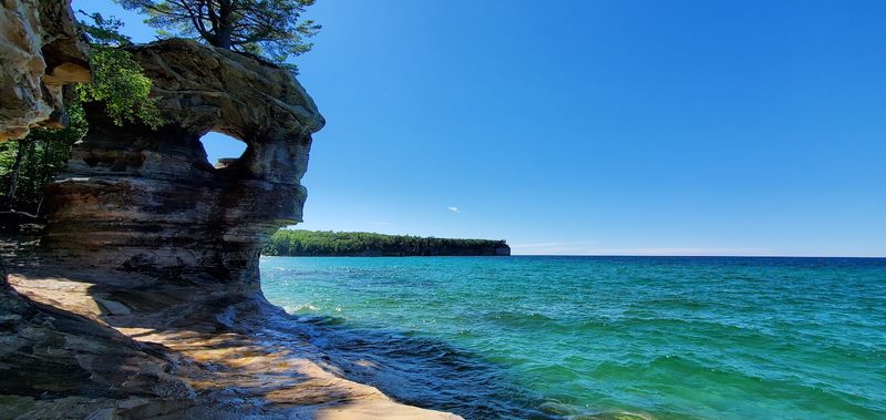
Long before any trail was cut through the Upper Peninsula forest, Lake Superior was already doing the heavy work. Chapel Rock is a freestanding sandstone pillar that juts up from the lakeshore with a presence that feels almost architectural, yet every curve and ledge on its surface was shaped purely by natural force.
The rock stands as a remnant of a much larger cliff wall, left behind as surrounding softer material eroded away over millennia.
The colors across the formation shift depending on the light and the season. Rust-red, cream, and burnt orange bands run horizontally through the stone, each stripe representing a different layer of ancient sediment compressed over hundreds of millions of years.
When the afternoon sun hits the west-facing face, the warm tones practically glow against the deep blue of the lake below.
Sandstone is not an especially hard rock, which makes Chapel Rock’s survival all the more striking. The same waves that carved it continue working on it today, slowly undercutting the base and widening the gap between the pillar and the main cliff.
Geologists consider formations like this to be temporary on a geological timescale, which adds an unexpected urgency to seeing it in person.
From water level, the scale becomes fully apparent. The pillar rises roughly 60 feet above the lake surface, and the overhang at its base creates a shadowed cave-like space where waves echo and splash.
Boat tours from Munising pass close enough to appreciate the full profile without disturbing the formation. Standing on the overlook trail above, the perspective shifts entirely, and the rock below looks like a chess piece placed deliberately on the edge of something enormous.
The Tree That Refuses To Let Go
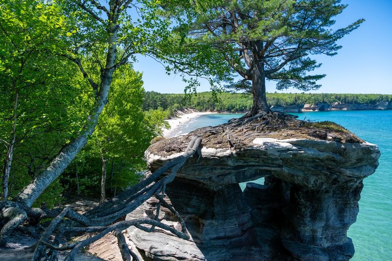
There is a white pine growing on top of Chapel Rock that should not, by any reasonable measure, still be alive. As the gap between the pillar and the mainland cliff widened over time, the tree’s root system was left fully exposed, stretching across open air in a tangle of thick, gnarled roots that now serve as the only physical connection between the two landmasses.
It looks like something a movie set designer would build, except no set designer would make it this convincing.
The root bridge spans several feet of open space, hanging above a drop that ends in cold lake water. The roots are thick enough that they have become a defining visual element of Chapel Rock itself.
Many visitors say the tree is what they remember most, not because it overshadows the rock, but because it makes the whole scene feel like a story mid-sentence.
White pines are famously resilient, and this one has adapted to conditions that would finish off most trees. The constant wind off Lake Superior, the nutrient-poor sandstone surface, and the exposed root system have all conspired against it.
Yet the crown still spreads, needles still grow, and the tree continues pulling whatever moisture and minerals it can from the stone beneath it.
Ecologically, the tree is a case study in survival under stress. Park rangers and naturalists have noted the root exposure for decades, watching how the tree responds to each season’s freeze-thaw cycle.
A bald eagle has been spotted perching in its upper branches, which adds another layer to an already layered scene. The tree is not a symbol placed there for effect.
It simply grew, adapted, and held on, which turns out to be more compelling than any symbol could be.
Chapel Falls Sets the Stage Before the Main Event
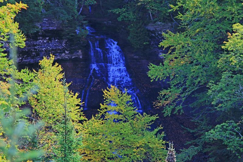
Most hikes to Chapel Rock begin at the trailhead off H-58, and the first major payoff comes well before the lakeshore. Chapel Falls drops roughly 60 feet through a narrow, forested gorge about 1.5 miles into the trail, and the sound of it reaches hikers before the falls come into view.
A wooden platform overlook positions visitors directly across from the cascade, close enough to feel the mist on warm days.
The falls run strongest in spring when snowmelt pushes extra volume through Chapel Creek. By midsummer, the flow slows considerably, but the gorge itself remains visually dramatic regardless of season.
Hemlock and birch crowd the edges, their roots gripping the mossy rock walls, creating a layered canopy that filters sunlight into shifting green patterns across the water below.
Stopping here is not optional for most hikers. The combination of sound, movement, and cool air creates a natural rest point that the trail almost forces you into.
Hiking poles help on the descent to the overlook platform, where the footing can be slippery after rain. The platform itself is well-positioned, offering a straight-on view of the full drop without requiring any scrambling.
Chapel Falls functions as a natural preview of what the landscape does throughout this entire section of Pictured Rocks. Water moves through the Upper Peninsula constantly, cutting channels, carving rock faces, and feeding the lake with cold, clear runoff.
The falls are not a detour from the Chapel Rock experience. They are the first chapter of it, and the transition from forest waterfall to open lakeshore cliff feels deliberate, even though nothing about it was planned by human hands.
Arrive early to have the overlook platform to yourself before the midday crowd fills the parking lot.
How Michigan’s Upper Peninsula Shaped This Corner of the Lakeshore
Pictured Rocks National Lakeshore stretches roughly 42 miles along the southern shore of Lake Superior in Michigan’s Upper Peninsula, and it became the first designated national lakeshore in the United States back in 1966. Chapel Rock sits near the western end of the protected stretch, within a section of coastline that concentrates some of the most dramatic cliff formations in the entire park.
The geology here is Munising Formation sandstone, deposited during the Cambrian period and later sculpted by glaciers and lake erosion.
The Upper Peninsula’s remoteness has historically worked in the landscape’s favor. Low population density, harsh winters, and limited road access kept large-scale development away from the shoreline long enough for the national lakeshore designation to take hold.
Today, the area around Chapel Rock sees significant seasonal foot traffic, but the surrounding forest and strict park management have kept the corridor largely intact.
Local Ojibwe communities have long held the Lake Superior shoreline as significant cultural and spiritual territory. The broader Pictured Rocks area appears in oral histories and traditional knowledge systems that predate European contact by centuries.
While Chapel Rock itself is not specifically documented in these records as a named cultural site, the landscape it belongs to carries deep Indigenous meaning that shapes how the region is understood by many who live nearby.
The town of Munising, about 20 miles west along H-58, serves as the primary gateway for most visitors. It offers lodging, outfitter services, and the boat tour dock that sends cruise vessels along the cliffs daily during the operating season.
The combination of accessible infrastructure and genuine wilderness just beyond town limits is part of what makes this section of Michigan’s shoreline function as well as it does for outdoor visitors.
Two Ways to See It, Both Worth Considering
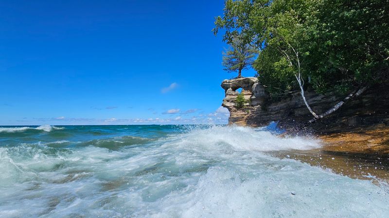
Chapel Rock can be reached by trail or by water, and the two approaches deliver genuinely different experiences rather than just different distances. The boat tour option leaves from Munising and covers the full lakeshore, passing Chapel Rock as part of a longer cruise that also takes in the Miners Castle formation, colored mineral streaks on the cliff faces, and sea caves carved into the base of the bluffs.
From the water, the full vertical scale of the rock becomes clear in a way that the overlook trail cannot replicate.
The hiking approach runs approximately 3 miles one way from the Chapel Road trailhead, with Chapel Falls as a midpoint stop and Chapel Beach waiting just beyond the rock formation itself. The trail is mostly flat with occasional root-covered sections and a few short climbs near the lakeshore.
Hiking poles help on wet or muddy stretches, which are common in spring and after summer rain. The round trip totals about 6 miles, though longer loop options extend the day considerably.
Serious hikers can build a 10 to 11-mile loop by continuing from Chapel Rock toward Mosquito Beach and back through the forest trail to the trailhead. That route adds Spray Falls, a dramatic cascade that drops directly into Lake Superior with no beach or pool at the base, just open lake.
Signage on the longer loop sections has been inconsistent, so downloading a trail map or using a GPS-enabled app before starting is a practical step, not just a precaution.
The boat tour covers more ground with less physical effort, but the hike delivers Chapel Beach, which the cruise cannot. Chapel Beach is a wide crescent of soft sand where the Chapel River meets the lake, and spending time there after the hike turns the whole outing into something more than a single landmark visit.
Choosing between the two often comes down to how much time is available.
Chapel Beach Is the Reward Hikers Don’t Expect
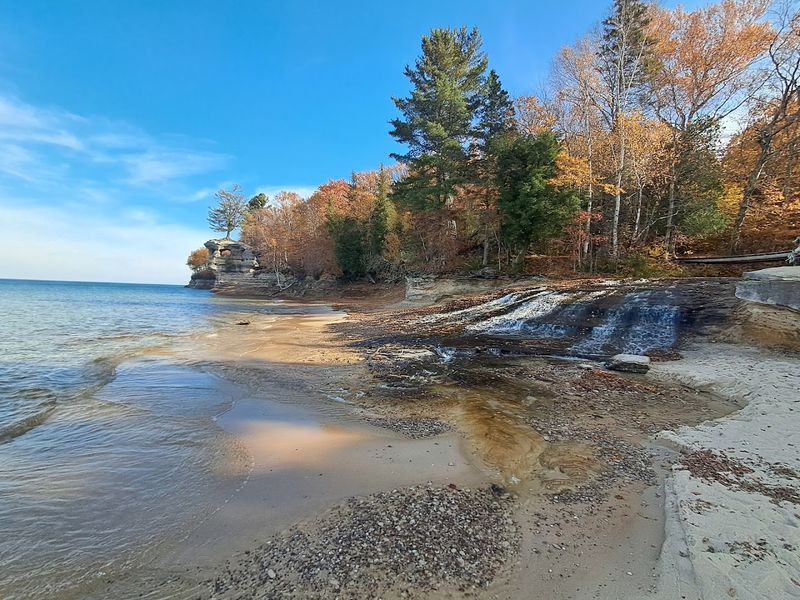
Just past Chapel Rock, the trail drops down to one of the most remote stretches of sand on Lake Superior’s southern shore. Chapel Beach is a wide, crescent-shaped beach where the Chapel River empties into the lake, creating a shallow, cold mixing zone at the waterline.
The sand is fine and pale, and the surrounding forest presses close on both sides, giving the beach a secluded quality that feels earned after the hike to reach it.
The water temperature at Chapel Beach rarely climbs above the low 60s Fahrenheit, even in the height of summer. Lake Superior’s thermal mass keeps it cold year-round, and the open exposure at this stretch of shore means wind can pick up quickly off the water.
Wading is common. Full swimming happens, but it takes a certain commitment to the cold.
A backcountry campsite sits at Chapel Beach, managed under the national lakeshore’s permit system. Overnight visitors who time their arrival for evening get the beach almost entirely to themselves, with nothing visible across the water except open lake and sky.
The Chapel River flows clear and fast through the beach before spreading out into the lake, and the sound of it mixing with the wave rhythm creates a layered audio backdrop that makes the campsite popular with those who know about it.
Day hikers typically spend 20 to 40 minutes at the beach before turning back. The combination of the rock formation above, the river at the shoreline, and the cold open water creates a scene that rewards slower movement.
Sliding rocks in the river shallows, as one reviewer noted, turns out to be a genuinely fun way to spend time at the water’s edge, especially for younger hikers who have been patient through the miles of forest trail to get there.
Planning Your Visit to Chapel Rock Without the Guesswork
The Chapel Road trailhead fills up faster than most visitors expect. Arriving before 9 a.m. on weekends between late June and mid-August almost guarantees a parking spot.
Arriving at 11 a.m. during peak weeks often means parking along the road shoulder and adding extra walking before the trail even begins. Weekday mornings are noticeably less crowded, and the light in the early hours is better for photography along the cliff sections anyway.
Bug spray is not optional from late May through July. The forest sections of the trail, particularly near Chapel Creek, host dense mosquito populations during warm, humid stretches.
A quality DEET-based repellent or permethrin-treated clothing makes the difference between a pleasant hike and a miserable one. Long sleeves help on the creek sections even when temperatures are warm.
Footwear matters more than the trail’s flat reputation suggests. Exposed tree roots cover long stretches of the path, and wet conditions turn clay sections into slick mud.
Trail runners with grip work well for experienced hikers. Heavier boots offer better ankle support for those who are less accustomed to uneven terrain.
Either way, avoid road shoes or sandals, which become problems quickly once the roots start.
Boat tours from Munising run on a seasonal schedule, typically from late spring through early October, with multiple departure times daily during peak season. Reservations fill quickly in July and August, so booking several days in advance is practical.
The cruise takes approximately two hours and covers the full lakeshore in both directions from the dock.
Drinking water is not available on the trail, so carrying at least two liters per person covers the round-trip comfortably. The trailhead has restroom facilities, but there are none along the route until the Chapel Beach area.
Cell service is unreliable past the trailhead, making a downloaded offline map a straightforward backup worth having.