Texas hiking doesn’t just mean cactus and dust. From thundering waterfalls hidden in limestone canyons to mountain peaks that touch the clouds, the Lone Star State offers trails that reward every step with jaw-dropping scenery. Whether you’re chasing autumn colors in the Hill Country or scrambling up rocky summits in West Texas, these paths deliver views that make the miles melt away.
1. Gorman Falls Trail (Bend)
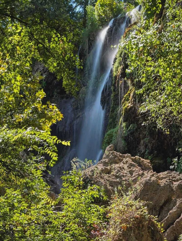
Reaching this 70-foot cascade requires a bit of effort, but the payoff is absolutely worth the sweat. The trail drops steeply through juniper and oak forest, losing about 250 feet of elevation before revealing one of the most photogenic waterfalls in the entire state. Turquoise water spills over travertine formations draped in emerald moss and ferns, creating a scene that looks more like Costa Rica than Central Texas.
The hike covers roughly three miles round trip, but the descent can be slippery, especially after rain. Sturdy shoes with good traction are essential since the limestone rocks stay damp year-round from underground springs. Most visitors spend at least 20 minutes at the bottom just soaking in the view and snapping photos from every angle.
Summer brings the heaviest flow, though the falls run consistently thanks to the spring-fed Colorado River upstream. Wildflowers bloom along the trail in spring, adding splashes of purple and yellow to the rocky landscape. The return climb challenges your legs, but benches positioned along the way offer convenient rest stops with views over the river valley below.
Colorado Bend State Park requires reservations for the guided Gorman Falls tours on weekends, though you can hike independently on weekdays. Arrive early because parking fills up fast, especially during peak fall foliage season when the surrounding trees put on their color show. The park also offers primitive camping if you want to explore other trails in the area, including the three-mile Spicewood Springs Trail that passes several smaller cascades.
Bring plenty of water since the climb back up generates serious thirst, and don’t forget your camera because this waterfall photographs beautifully from multiple vantage points along the viewing platform at the base.
2. Lost Mine Trail (Terlingua)
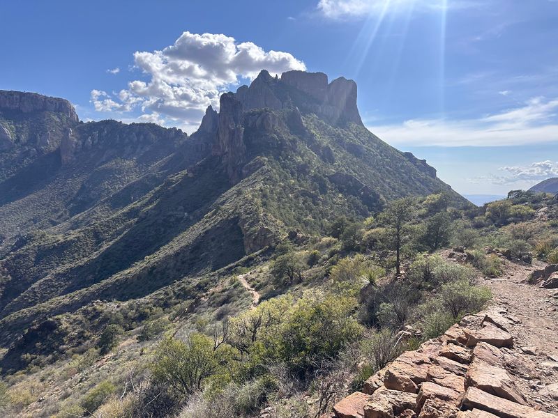
Big Bend’s most popular hike earns its reputation with sweeping desert vistas that stretch all the way into Mexico. The trail climbs steadily for 2.4 miles through Chisos Mountain forest, gaining about 1,100 feet before reaching a rocky overlook perched above Juniper Canyon. On clear days, you can spot Casa Grande peak, Pine Canyon, and the vast Chihuahuan Desert spreading endlessly below.
Pine and juniper trees provide occasional shade during the ascent, a welcome relief in a park known for scorching temperatures. The path stays well-maintained with stone steps in the steeper sections, making it accessible for moderately fit hikers. Interpretive signs along the way explain the geology and ecology of this unique mountain island rising from the desert floor.
Morning hikes offer the best lighting for photography, with soft golden rays illuminating the layered mountains in shades of purple and blue. Wildlife sightings happen frequently, including Mexican jays, rock squirrels, and occasionally black bears foraging in the oak trees. The final push to the overlook involves some scrambling over boulders, but railings help with the trickiest spots.
Legend says Spanish conquistadors hid treasure in these mountains, giving the trail its mysterious name. Whether or not gold lies buried nearby, the real treasure sits right in front of you at the summit. Cooler months from October through April provide the most comfortable hiking conditions, though the trail stays open year-round.
Sunset hikes are magical but require a headlamp for the return journey since darkness falls quickly in the mountains. The trailhead sits along the Chisos Basin Road, with parking available at the Chisos Basin Visitor Center just a short drive away.
3. Devil’s Waterhole Nature Trail (Burnet)
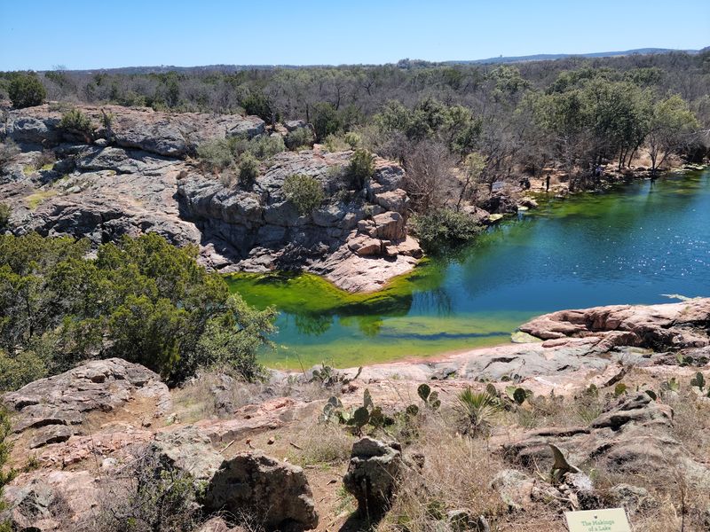
This short but scenic loop packs serious visual punch into just 1.5 miles. The trail winds through cedar breaks and oak groves before arriving at a spring-fed pool where water pours through a narrow gap in the limestone bedrock. The swimming hole glows bright turquoise on sunny days, fed by underground springs that keep the water refreshingly cool even in August.
Families love this hike because the relatively flat terrain works well for kids, though a few rocky sections require careful footing. Massive cypress trees shade the water’s edge, their roots creating natural benches perfect for picnicking after a swim. Local legends claim the unusual rock formation resembles a devil’s face, though most visitors are too busy enjoying the water to search for spooky shapes.
The trail connects to longer paths within Inks Lake State Park, allowing you to extend your adventure if the views inspire more exploration. Birdsong fills the air as cardinals, wrens, and woodpeckers flit through the canopy overhead. Wildflowers bloom abundantly in spring, painting the hillsides with bluebonnets, Indian paintbrush, and Mexican hat.
Swimming is allowed and highly encouraged during the hot summer months, though the waterhole gets crowded on weekends. Weekday mornings offer a more peaceful experience with better chances of spotting white-tailed deer drinking at the water’s edge. The park charges a small entrance fee, but annual Texas State Parks passes provide unlimited access.
Restrooms and picnic areas sit near the trailhead, making this an ideal spot for a half-day outing. Rock formations along the shore provide excellent platforms for jumping into the deeper sections, though always check water depth first. Bring water shoes since the rocky bottom can be tough on bare feet.
4. Guadalupe Peak Trail (Salt Flat)
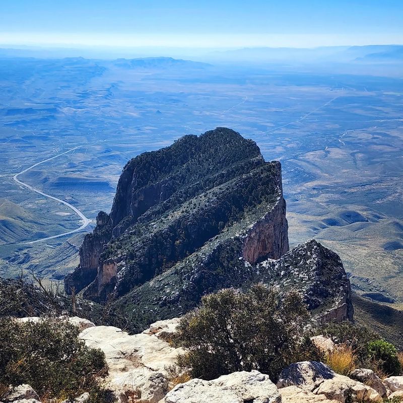
Standing atop Texas at 8,751 feet delivers a sense of accomplishment few other hikes can match. The trail to Guadalupe Peak climbs relentlessly for 4.2 miles, gaining over 3,000 feet of elevation through multiple ecological zones. You’ll start in Chihuahuan Desert scrubland and finish above the tree line where fierce winds whip across exposed limestone.
The first two miles pass through mountain mahogany and piñon pine forests that provide occasional shade and windbreaks. Switchbacks help manage the steep grade, though your heart rate will definitely climb along with your altitude. About halfway up, the trees thin out and views begin opening toward El Capitan, the massive limestone cliff that dominates the western skyline.
The final mile tests your determination as the trail becomes rockier and steeper, with loose stones requiring careful foot placement. But once you reach the summit pyramid, the 360-degree panorama makes every burning quad muscle worth it. On exceptionally clear days, you can see 100 miles in every direction, with mountain ranges rippling across New Mexico and West Texas like frozen ocean waves.
A metal monument marks Texas’s highest point, installed by American Airlines employees in 1958. Most hikers sign the register kept in a metal box nearby, adding their names to thousands of others who’ve conquered this peak. Start early because afternoon thunderstorms build quickly in summer, bringing dangerous lightning to the exposed summit.
The round trip typically takes six to eight hours depending on fitness level and how long you linger at the top. Bring layers since temperatures at the summit run 20 degrees cooler than the trailhead, and wind chill can make it feel even colder. Water is crucial since no sources exist along the trail.
5. Pedernales Falls Trail System (Johnson City)
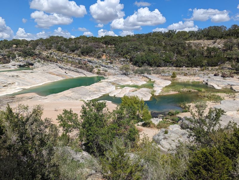
Water sculpted this landscape over millions of years, carving smooth channels through solid limestone bedrock. The falls themselves aren’t a single dramatic drop but rather a series of cascades spreading across a 300-foot-wide riverbed. When the Pedernales River runs high after spring rains, the entire expanse transforms into a thundering whitewater spectacle that echoes through the canyon.
Multiple trails crisscross the park, ranging from easy quarter-mile strolls to challenging six-mile loops. The most popular route follows the river’s edge, offering constantly changing perspectives of the falls and surrounding Hill Country terrain. Limestone shelves create perfect natural viewing platforms, though caution is essential since the smooth rock becomes dangerously slippery when wet.
Fall and winter bring the most dramatic water flow, though summer’s lower levels reveal fascinating geological features usually hidden underwater. Ancient fossils embedded in the limestone tell stories of shallow seas that covered Texas 300 million years ago. Cypress trees line the riverbanks, their rust-colored needles creating stunning contrasts against the white rock in autumn.
The park prohibits swimming near the falls due to dangerous currents and submerged hazards, but designated swimming areas exist upstream where the water flows more gently. Primitive campsites allow overnight stays for those wanting to catch sunrise over the falls, when golden light paints the limestone in warm amber tones. Wildlife thrives here, including armadillos, roadrunners, and occasionally river otters playing in the pools.
Spring wildflower displays rival any in the state, with bluebonnets, Indian blanket, and wine cups carpeting the hillsides. The trailhead provides ample parking, restrooms, and shaded picnic areas. Arrive early on weekends because this popular park reaches capacity quickly, especially during peak bluebonnet season in April.
6. Upper Canyon Trail (Quitaque)
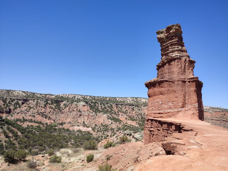
Palo Duro Canyon stretches 120 miles long and plunges 800 feet deep, earning its nickname as the Grand Canyon of Texas. The Upper Canyon Trail explores a quieter section away from the main visitor areas, where red rock walls tower overhead in stunning bands of rust, orange, and cream. This six-mile route follows the canyon rim before descending into side canyons that feel worlds away from civilization.
Juniper trees cling to rocky ledges, their twisted trunks sculpted by constant wind. The trail surface varies from packed dirt to loose gravel, with some sections requiring scrambling over boulders. Views constantly evolve as you round each bend, revealing new formations carved by wind and water over millions of years.
Morning light brings out the richest colors in the canyon walls, making sunrise hikes particularly rewarding for photographers. The relative isolation means you might hike for hours without seeing another person, accompanied only by the calls of canyon wrens echoing off stone walls. Lizards dart across the trail, and if you’re lucky, you might spot a roadrunner sprinting through the brush.
The canyon’s sheer scale becomes apparent from higher vantage points, where the Prairie Dog Town Fork of the Red River appears as a thin silver ribbon far below. Temperature swings can be dramatic, with canyon bottoms staying 10-15 degrees warmer than the rim. Summer heat makes this hike brutal midday, so stick to early morning or evening excursions during warmer months.
Winter offers surprisingly pleasant hiking conditions, though ice can form on shaded sections of trail. Bring more water than you think you’ll need since the dry air and constant sun create serious dehydration risks. The trailhead lacks facilities, so plan accordingly and pack out all trash to preserve this spectacular landscape for future visitors.
7. Enchanted Rock Summit Trail (Fredericksburg)
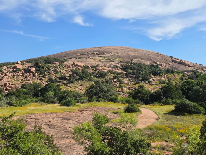
A massive pink granite dome rises 425 feet above the surrounding Hill Country, visible for miles in every direction. The summit trail climbs straight up the rock face, following a path worn smooth by thousands of boots over the decades. What looks intimidating from the parking lot becomes an achievable challenge once you start climbing, with the steepest sections offering handholds and painted markers to guide your route.
The bare granite heats up quickly under the Texas sun, so early morning hikes provide the most comfortable conditions. As you ascend, the views expand dramatically with each step, revealing rolling hills dotted with oak trees stretching to the horizon. Vernal pools dot the rock surface after rains, creating temporary ecosystems where fairy shrimp hatch and complete their entire life cycles in just weeks.
The summit plateau spreads across 640 acres, offering plenty of space to explore beyond the main trail. Smaller domes and rock formations create a moonscape-like environment that feels otherworldly. On quiet days, you can hear the rock itself groaning and cracking as it expands and contracts with temperature changes, giving the place its mystical reputation.
Native Americans considered this site sacred, and it’s easy to understand why when you’re standing on top watching hawks circle below you. The round-trip hike covers just over a mile but gains significant elevation, making it more challenging than the distance suggests. Reservations are required for park entry and sell out weeks in advance during peak seasons, so plan ahead.
The rock surface becomes dangerously slippery when wet or icy, and the park closes the summit trail during severe weather. Sunset from the top ranks among Texas’s most spectacular natural shows, with the granite glowing pink and orange as the sun sinks below the hills.
8. Government Canyon Overlook Trail (San Antonio)
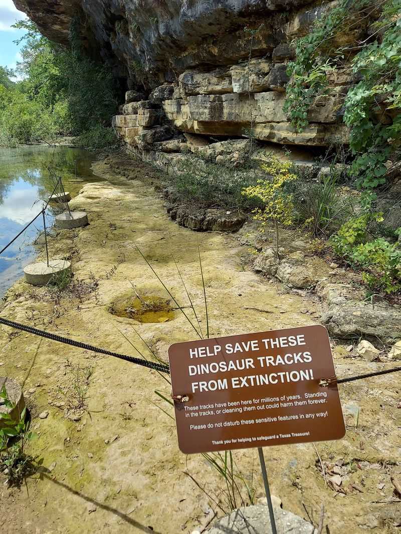
Just 20 minutes from downtown San Antonio, this preserve protects 12,000 acres of wild Hill Country terrain. The overlook trail climbs steadily for 2.8 miles through oak savanna and juniper thickets before reaching a limestone bluff with commanding views. From this vantage point, you can see the transition zone where Texas Hill Country meets South Texas brush country, creating a unique blend of ecosystems.
The trail stays well-marked with colored posts, though rocky sections require attention to avoid twisted ankles. Elevation gain totals about 500 feet, enough to get your blood pumping without completely exhausting casual hikers. Interpretive signs explain the area’s geology, noting the Edwards Aquifer recharge zone beneath your feet that supplies drinking water to millions of Texans.
Wildlife sightings happen frequently since the preserve’s size allows animals to thrive relatively undisturbed. White-tailed deer browse in the clearings, while golden-cheeked warblers nest in the mature juniper breaks during spring migration. Armadillos shuffle through leaf litter, and occasionally a fox or bobcat crosses the trail ahead.
The overlook itself features a wooden platform and benches where you can rest and enjoy the panorama. Layers of limestone form distinctive bands in the canyon walls, each representing different geological periods. On clear days, you can spot downtown San Antonio’s skyline in the distance, a reminder of how close this wilderness sits to major urban development.
The preserve only opens on weekends and requires advance reservations to control visitor numbers and protect sensitive habitat. Bring binoculars for birdwatching and plenty of water since no sources exist along the trail. The parking area includes restrooms and covered picnic tables.
Consider extending your visit by exploring some of the preserve’s other trails, including routes to dinosaur tracks and historic homestead ruins.
9. Maple Trail at Lost Maples (Vanderpool)
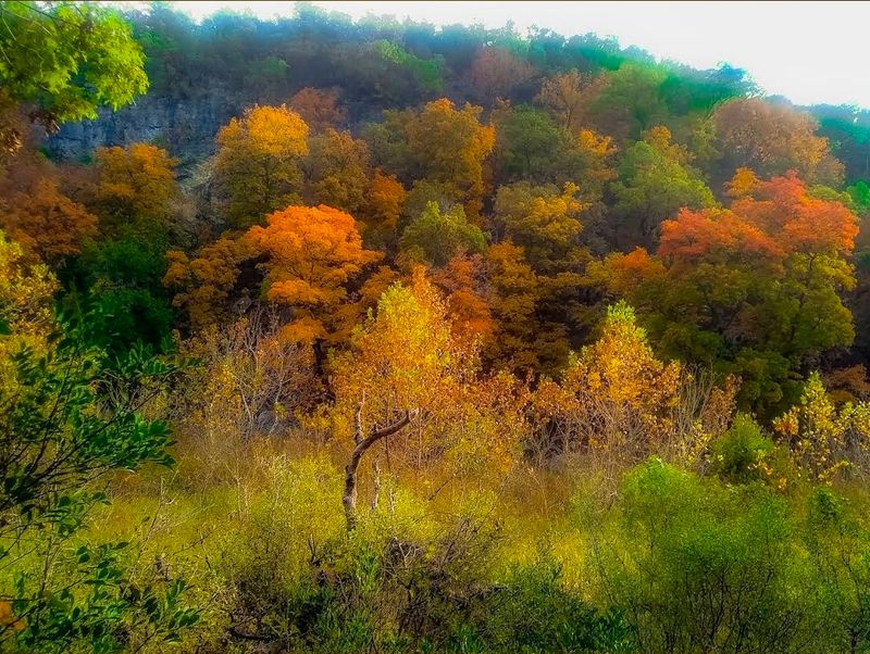
Texas isn’t exactly famous for fall foliage, but this hidden canyon defies expectations spectacularly. Bigtooth maples, rare this far south, explode into brilliant reds, oranges, and yellows each November, creating a color show that rivals New England. The 4.8-mile loop trail follows the Sabinal River through a protected canyon where these trees found refuge during the last ice age.
The trail starts gently along the river, where clear pools reflect the changing leaves overhead. Cypress trees line the banks, their roots creating natural sculptures in the limestone bedrock. As you progress deeper into the canyon, the walls close in and the maple concentration increases, eventually forming a tunnel of color overhead.
Peak color typically arrives around Thanksgiving weekend, though timing varies depending on weather patterns. Cold snaps trigger the color change, and a mild autumn can delay the show into December. The park posts color reports on social media, helping visitors time their trips perfectly.
Even outside peak season, the trail offers beauty with spring wildflowers and summer swimming holes.
Steep sections test your endurance, particularly the climb out of the canyon on the return loop. Benches positioned at strategic overlooks provide rest stops with views back down into the colorful canyon. The trail can get crowded during peak weekends, with the parking lot filling by 9 a.m.
Weekdays or early morning arrivals offer more solitude to enjoy the spectacle. The park requires reservations during peak color season, and spots book up months in advance. Primitive camping allows overnight stays for those wanting to photograph the maples at sunrise when morning mist adds ethereal quality to the scene.
Bring layers since canyon temperatures fluctuate significantly, and pack snacks for energy on the longer climbs.
10. Hamilton Pool Trail (Dripping Springs)
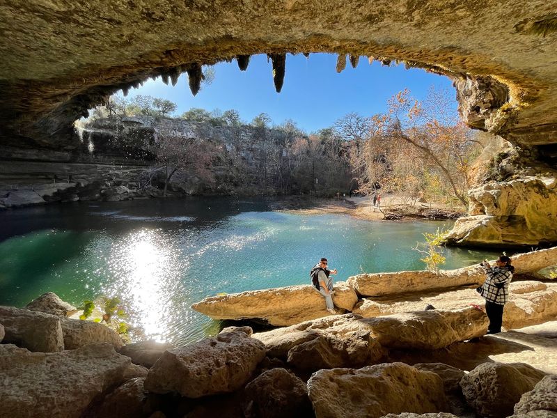
A collapsed grotto creates one of Texas’s most photographed natural wonders. The trail drops a quarter-mile through juniper forest, losing about 200 feet of elevation before revealing a jade-green pool fed by a 50-foot waterfall. The ceiling of the grotto still partially covers the pool, with stalactites hanging overhead and sunlight filtering through the opening above.
The limestone walls drip with moisture year-round, supporting lush ferns and mosses that seem out of place in typically dry Texas. Water flows consistently thanks to underground springs, though the waterfall itself runs strongest after heavy rains. During summer, the pool becomes a swimming destination, with depths reaching 25 feet in the center.
Reservations are absolutely required and must be made weeks in advance since this popular spot limits daily visitors to protect the fragile ecosystem. The short trail stays crowded even with visitor limits, as everyone wants photos of this Instagram-famous location. Arrive at your reserved time and expect to share the space with other nature lovers, though the magical setting makes the crowds bearable.
Swimming gets periodically closed when bacteria levels rise, so check the preserve’s website before visiting. Even when swimming is prohibited, the views alone justify the trip. The trail continues past the pool to additional overlooks and connects to longer routes through the surrounding preserve.
Photographers love the challenge of capturing the interplay between light, water, and stone, with the best lighting occurring midday when sun beams directly through the grotto opening. The steep return climb takes most visitors by surprise after they’ve lingered at the pool, so save some energy for the ascent. Facilities at the trailhead include restrooms and picnic areas.
The preserve also protects archaeological sites and rare plant species, making it an important conservation area beyond its scenic beauty.
11. Mundy’s Gap Trail (El Paso)
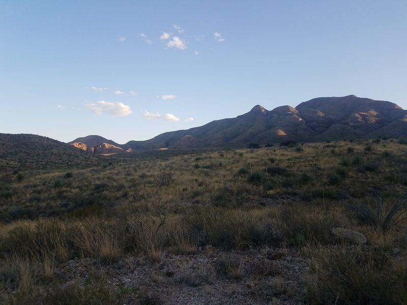
El Paso’s backyard wilderness offers some of the most dramatic urban-adjacent hiking in Texas. This challenging 5.8-mile trail climbs 2,200 feet through the Franklin Mountains, rewarding the effort with sweeping views across two countries. The rocky path switchbacks relentlessly upward through Chihuahuan Desert vegetation, passing towering ocotillo, prickly pear, and century plants clinging to impossibly steep slopes.
The lower sections expose you to full sun with minimal shade, making early morning starts essential during warmer months. As you gain elevation, the city sprawl below shrinks to toy-sized proportions while mountain ridges come into sharper focus. The trail surface varies from packed dirt to loose scree that slides underfoot, demanding constant attention and sturdy boots.
About halfway up, the grade moderates slightly as you traverse across the mountainside rather than straight up. Here the views really open up, revealing El Paso to the south, Juarez spreading across the valley to the west, and the Rio Grande snaking between them. The international border becomes a visible line where different urban patterns meet at the river.
The gap itself sits at 5,426 feet, a saddle between two peaks where wind funnels through with surprising force. Hikers often continue to nearby peaks for even better vistas, adding mileage and elevation to an already strenuous outing. Desert wildlife thrives here despite the harsh conditions, including roadrunners, jackrabbits, and occasionally mountain lions, though the big cats typically avoid humans.
Rattlesnakes sun themselves on rocks during warmer months, so watch where you place your hands and feet. The trailhead provides limited parking that fills quickly on pleasant weekend mornings. Bring at least twice the water you think you’ll need since the desert environment and elevation combine to cause rapid dehydration.
Afternoon thunderstorms can develop quickly in summer, bringing lightning danger to exposed ridges.
Share this story