Texas is home to some of the most stunning and unusual rock formations in the country, shaped over millions of years by wind, water, and volcanic activity. From towering canyon walls to ancient granite domes, these natural wonders offer breathtaking views and unforgettable adventures for anyone who loves the outdoors. Whether you’re a hiker, photographer, or just someone who appreciates the raw beauty of nature, these incredible rock formations are calling your name in 2026.
1. Enchanted Rock (Fredericksburg/Llano area)
")
Rising 425 feet above the surrounding Hill Country, this massive pink granite dome has been drawing visitors for thousands of years. The rock itself is actually a batholith, which means it formed underground and was slowly exposed as softer rock eroded away over millions of years. When you stand at the base and look up, the sheer size of this thing hits you differently than any photo can capture.
The hike to the summit takes most people about an hour, and while it’s steep in places, the trail is well-maintained and manageable for anyone in decent shape. Kids as young as five or six make it to the top regularly with their families. The granite surface can get slippery after rain, so good shoes with traction are essential, not optional.
Once you reach the summit, the 360-degree views stretch for miles across the Texas Hill Country. On clear days, you can see the surrounding towns and rolling hills that seem to go on forever. The rock itself is fascinating up close—you’ll notice small pools called vernal pools that fill with rainwater and support unique ecosystems of fairy shrimp and other tiny creatures.
Early morning visits offer cooler temperatures and softer light that makes the pink granite glow. Sunset is equally spectacular, though you’ll want to bring a headlamp for the descent. The park also offers backcountry camping, rock climbing routes, and several miles of hiking trails that loop around the base if you’re not up for the summit climb.
One quirky detail: the rock actually makes creaking and groaning sounds at night as it cools and contracts after heating up all day. Indigenous peoples considered this place sacred, and when you experience the quiet power of this ancient dome, you’ll understand why. Enchanted Rock State Natural Area charges a modest entrance fee, and reservations are recommended on weekends since the park reaches capacity quickly during peak seasons.
2. Palo Duro Canyon / Lighthouse Rock (Canyon)
")
Stretching 120 miles long and plunging 800 feet deep, Palo Duro Canyon earns its nickname as the Grand Canyon of Texas. The layered rock walls tell a geological story spanning 250 million years, with each colorful band representing a different era. Red mudstones, orange sandstones, and white gypsum layers create a painter’s palette that shifts with the changing light throughout the day.
Lighthouse Rock stands as the canyon’s most recognizable landmark—a 310-foot tall hoodoo that looks exactly like its name suggests. The trail to reach it covers about six miles round trip and gains roughly 500 feet in elevation. Plan on three to four hours for the full experience, including time to catch your breath and take photos at the base of this towering formation.
The hike starts easy enough on relatively flat terrain, but the final push involves some rocky scrambling that requires attention and decent footwear. Summer temperatures regularly exceed 100 degrees, so most experienced visitors tackle this trail before 10 AM or after 4 PM. Carrying at least two liters of water per person isn’t being cautious—it’s being smart.
What makes Lighthouse Rock special isn’t just its size but its isolation. Standing alone on the canyon floor, this pillar of Triassic-era rock has survived millions of years while softer surrounding material eroded away. Geologists call these formations hoodoos, and they’re relatively rare in Texas.
The canyon offers 30 miles of trails beyond just Lighthouse Rock, plus camping, horseback riding, and a summer musical drama performed in an outdoor amphitheater. Wildlife sightings include roadrunners, mule deer, and the official Texas State Bison Herd that roams freely through the park. Spring wildflowers transform the canyon floor into a colorful carpet, while fall brings cooler temperatures and fewer crowds.
Entrance fees are reasonable, and the park maintains excellent facilities including showers and a camp store.
3. Santa Elena Canyon (Big Bend National Park)
")
Vertical limestone walls shoot 1,500 feet straight up from the Rio Grande, creating one of the most dramatic geological features in Texas. Santa Elena Canyon marks the border between the United States and Mexico, with the river carving through millions of years of ancient seabed turned to stone. The canyon entrance alone stops most first-time visitors in their tracks—it’s that impressive.
The trail into the canyon starts with a quick crossing of Terlingua Creek, which can be ankle-deep or completely dry depending on recent rainfall. Once past the creek, you’ll climb a series of concrete steps built into the rock face that gain elevation quickly. These steps can be challenging for anyone with knee issues, but they’re necessary to access the canyon floor.
Walking into the canyon feels like entering a natural cathedral. The walls narrow until you’re standing in a corridor of stone with just a ribbon of sky visible overhead. The Rio Grande flows peacefully here most of the year, though flash floods can turn this tranquil scene into a raging torrent within minutes during storms.
Photography enthusiasts love the play of light and shadow on the canyon walls, especially during midday when sunlight penetrates deep into the narrow passage. The limestone shows distinct layers and fossils from ancient marine life that lived here 100 million years ago when this area was covered by a shallow sea.
The maintained trail extends about 1.7 miles into the canyon before ending at a point where the river blocks further progress. Serious adventurers with proper equipment can continue deeper by wading or kayaking, but most visitors find the main trail provides plenty of spectacular views. Temperatures inside the canyon run cooler than the surrounding desert, making this a pleasant escape during hot months.
Rangers recommend avoiding this trail during and immediately after heavy rain due to flash flood danger. No entrance fee beyond the park admission, and the trailhead offers parking and a vault toilet.
4. Boquillas Canyon (Big Bend National Park)
")
Towering canyon walls frame the Rio Grande as it winds through some of the most remote desert landscape in Texas. Boquillas Canyon offers a quieter, less-visited alternative to its famous neighbor Santa Elena, but the geological drama here matches anything else in Big Bend. The rock layers visible in these walls span millions of years and multiple geological periods.
Getting here requires a 1.4-mile walk from the parking area to the canyon mouth, mostly flat and easy going across desert terrain. The trail passes through classic Chihuahuan Desert habitat with ocotillo, lechuguilla, and creosote bush lining the path. Keep your eyes open for roadrunners and collared lizards that dart across the trail.
At the canyon entrance, a sandy beach area invites you to sit and contemplate the sheer walls rising on both sides of the river. The acoustics here are remarkable—sounds bounce off the rock faces in unexpected ways. Some visitors report hearing singing or music drifting across from the Mexican village of Boquillas del Carmen on the opposite bank.
A short trail continues into the canyon along the U.S. side, winding through river cane and tamarisk before reaching a natural sand slide that kids love to climb and slide down. The rock walls show beautiful examples of cross-bedding and other sedimentary structures that tell the story of ancient river systems that existed here long before the modern Rio Grande.
Unlike some Big Bend trails, this one stays relatively level and accessible for families with younger children or anyone who wants canyon views without serious elevation gain. The round trip covers less than three miles total. Late afternoon light paints the canyon walls in shades of gold and amber that photographers dream about.
Summers get brutally hot, so spring and fall visits make the most sense unless you’re starting at dawn. The remoteness means no facilities at the trailhead beyond a parking area, so come prepared with water and supplies.
5. Pedernales Falls limestone slabs (Johnson City)
")
Sheets of limestone stretch across the Pedernales River like a giant’s staircase, creating a series of cascades and pools that change character with every season. When water levels drop, the exposed rock reveals fascinating patterns carved by millions of years of flowing water. These aren’t dramatic vertical waterfalls but rather a series of tilted limestone layers that create small drops and rapids across a wide expanse.
The rock here belongs to the Hensel Sand Formation, dating back about 110 million years to the Cretaceous Period. Walking across the dry limestone slabs, you’ll notice circular depressions called potholes—some as small as a dinner plate, others large enough to swim in. These form when rocks and pebbles get caught in small depressions and swirl around, gradually grinding deeper holes into the limestone.
The main overlook provides a perfect vantage point to appreciate the full scope of these formations without getting your feet wet. From here, you can see how the rock layers tilt at an angle, creating the distinctive stepped appearance. During periods of low water, families walk out onto the exposed limestone to explore the pools and channels up close.
Flash flooding poses a real danger here, and park rangers take it seriously. When heavy rain falls upstream, the peaceful river can transform into a deadly wall of water within minutes. Signs throughout the park warn visitors to move to high ground immediately if water levels start rising, and multiple deaths have occurred when people ignored these warnings.
Swimming and wading are popular when conditions permit, though the current can be deceptively strong even when the water looks calm. The limestone can be slippery with algae, so water shoes with good grip make sense if you plan to explore. Beyond the falls themselves, the park offers nearly 20 miles of hiking and mountain biking trails through typical Hill Country terrain.
Camping facilities include both primitive sites and ones with water and electricity. Spring brings the best wildflower displays, while fall offers comfortable temperatures and beautiful foliage along the river.
6. Natural Bridge Caverns (San Antonio area)
")
Descending 180 feet underground into a living cave system reveals a hidden world of limestone formations that have been growing for thousands of years. Natural Bridge Caverns got its name from the 60-foot natural limestone bridge spanning the entrance, but the real magic happens deep inside the earth. The main tour route winds through massive chambers decorated with stalactites, stalagmites, flowstones, and rare formations found in few other caves.
The Discovery Tour covers about three-quarters of a mile and takes roughly 70 minutes, with guides explaining how these formations develop at the glacial pace of about one cubic inch per century. The temperature stays at a constant 70 degrees year-round, which feels refreshingly cool in summer and surprisingly warm in winter. Humidity runs close to 99 percent, so glasses tend to fog up and cameras can struggle with condensation.
Some formations reach floor-to-ceiling heights of 40 feet or more, creating columns that look almost too perfect to be natural. The colors range from pure white calcite to rusty oranges and browns where iron and other minerals stained the rock. One chamber called the Castle of the White Giants contains some of the largest and most pristine formations in the entire cave system.
For adventurous visitors, the caverns offer more challenging tours including the Hidden Passages Tour that involves crawling through tight spaces and getting muddy. These adventure tours require reservations and have age and physical fitness requirements. The standard walking tour, however, accommodates most fitness levels, though it does involve climbing stairs equivalent to a 15-story building.
Above ground, the property includes a zip line course, a massive rope maze suspended above a canyon, and gem mining activities that kids enjoy. The cave formations are still actively growing, which means you’re seeing a living geological process rather than a fossil record. Scientists monitor the cave environment carefully to protect the delicate formations from damage caused by too many visitors or changes in temperature and humidity.
Admission prices are higher than state parks but include the guided tour, and combination packages with the adventure activities can save money if you plan to do multiple experiences.
7. Dinosaur Valley limestone riverbeds (Glen Rose)
")
Walking in the literal footsteps of creatures that lived 113 million years ago creates a connection to deep time that’s hard to match anywhere else. The Paluxy River has carved through layers of Glen Rose limestone, exposing trackways where sauropods and theropods walked across what was then a muddy shoreline. Some individual prints measure three feet across, giving you a visceral sense of just how massive these animals were.
The tracks appear most clearly during summer and fall when water levels drop and expose more of the limestone riverbed. Park staff can direct you to the best viewing spots on any given day, since river conditions change constantly. Some trackways run for dozens of feet, showing where a dinosaur walked in a straight line before changing direction or stopping.
Wading into the river to get close to the tracks is allowed and encouraged, making this one of the few places where you can actually touch genuine dinosaur fossils. The limestone feels smooth under your feet, worn by millions of years of water flow. Look carefully and you’ll also spot fossilized ripple marks, mud cracks, and even some plant impressions preserved in the same rock layers.
Two separate track sites sit within easy walking distance of the parking areas. The Denio site shows prints from a large theropod (meat-eater) following what appears to be a sauropod (long-necked plant-eater), leading to speculation about possible predator-prey interactions. Scientists debate whether this represents an actual chase or just two animals passing through at different times.
Beyond the famous tracks, the park offers swimming holes, camping, hiking trails, and even a few mounted dinosaur models that kids love to climb on for photos. The river valley creates a green corridor through typical Texas prairie, supporting more diverse plant and animal life than the surrounding uplands. Summer weekends get crowded, so weekday visits or early morning arrivals work best if you want to explore the trackways without competing for space.
The entrance fee is standard for Texas state parks, and the facilities include restrooms, picnic areas, and a small visitor center with additional fossil displays.
8. Caprock Canyons red rock formations (Quitaque)
")
Crimson cliffs and rust-colored spires rise from the canyon floor in layers so vivid they look painted rather than natural. Caprock Canyons showcases some of the most colorful geology in Texas, with rock formations spanning 250 million years of Earth history. The red color comes from iron oxide—essentially rust—that stains the sandstone and mudstone layers deposited when this area was covered by ancient seas and river deltas.
The park sits at the edge of the Caprock Escarpment, a dramatic drop-off where the flat High Plains suddenly plunge into broken canyon country. This geological boundary runs for hundreds of miles across the Texas Panhandle. The canyons themselves were carved by the Little Red River and its tributaries over the past few million years.
Hiking trails wind through narrow canyons with walls that glow in shades of red, orange, pink, and cream. The Upper Canyon Trail offers a relatively easy 2.2-mile walk that provides excellent views without serious elevation changes. For more adventure, the Haynes Ridge Overlook Trail climbs to a high point with panoramic views across the canyon system.
One unique feature here is the official Texas State Bison Herd that roams freely through the park. Seeing these massive animals against the backdrop of red rock formations creates a scene straight out of the Old West. Photographers camp out at dawn and dusk hoping to capture bison silhouetted against the colorful canyon walls.
The Clarity Tunnel, a narrow passage through solid rock, provides a fun scramble for kids and adults alike. Rock layers throughout the park show clear examples of cross-bedding, ripple marks, and other sedimentary structures that reveal how these rocks formed. Fossils are less common here than in some other Texas formations, but patient searchers occasionally spot plant impressions or shell fragments.
Camping options range from primitive backcountry sites to developed campgrounds with water and electricity. The park’s remote location means dark skies perfect for stargazing, with the Milky Way visible on clear nights. Spring and fall offer the most comfortable weather, while summer temperatures can exceed 100 degrees.
The park also maintains over 90 miles of mountain bike trails that have earned national recognition among cycling enthusiasts.
9. Hueco Tanks rock basins (El Paso)
")
Massive granite and syenite boulders pile up in seemingly impossible stacks, creating a landscape that looks more like a sculptor’s fantasy than natural geology. Hueco Tanks gets its name from the Spanish word for hollow—the rock basins that collect and hold rainwater in this desert environment. These natural water sources have drawn humans to this spot for at least 10,000 years, making it one of the most important archaeological sites in the Southwest.
The rocks themselves formed deep underground about 34 million years ago as molten magma cooled slowly. Over millions of years, erosion removed the overlying rock and exposed these formations. Weathering created the rounded shapes and hollows we see today, with some boulders balanced in ways that seem to defy gravity.
More than 200 pictograph sites cover the rocks, with images created by at least three different cultural groups over thousands of years. Some paintings show human figures, animals, and abstract designs in red, black, yellow, and white pigments. The most famous is a striking mask-like face that has become the symbol of the park.
Access to areas with rock art requires guided tours to protect these irreplaceable cultural resources.
Rock climbers discovered Hueco Tanks in the 1980s, and it quickly became one of the premier bouldering destinations in North America. The rock offers thousands of climbing problems ranging from beginner-friendly to world-class difficult. Climbers must make reservations and follow strict rules to minimize impact on the rock art and natural environment.
The basins that give the park its name can hold thousands of gallons of water after heavy rains. This reliable water source made the difference between life and death for travelers crossing the Chihuahuan Desert. Even today, the tanks support unique ecosystems of fairy shrimp, spadefoot toads, and aquatic insects that can survive months of drought as eggs or in dormant states.
Park access is strictly limited to protect both natural and cultural resources, with daily visitor caps and advance reservations required. Self-guided access covers only about five percent of the park, while the rest requires joining a ranger-led tour. This limitation preserves the site’s special character and prevents the overcrowding that has damaged similar areas.
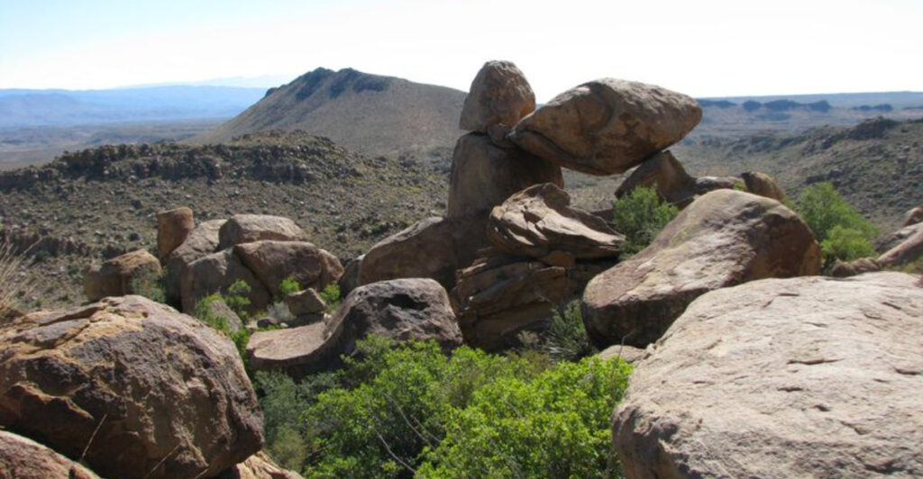
10. Balanced Rock / Grapevine Hills (Big Bend National Park)
")
A massive boulder perches impossibly between two supporting rocks, creating a window frame that photographers dream about. Balanced Rock sits at the end of a 2.2-mile round-trip hike through the Grapevine Hills, a landscape of eroded volcanic rock that looks like something from another planet. The trail crosses a sandy wash before climbing through jumbled boulders to reach the famous formation.
These rocks started as molten magma that intruded into older rock layers about 32 million years ago. As the softer surrounding rock eroded away, the harder igneous rock remained, weathering into the rounded boulders and unusual formations we see today. Geologists call this type of rock syenite—similar to granite but with different mineral composition.
The hike starts easy enough on relatively flat terrain, but the final approach involves scrambling over and between large boulders. Most people need about an hour to reach Balanced Rock, though photographers often spend much longer waiting for perfect light. The trail isn’t difficult, but it does require basic agility and comfort with uneven footing.
Standing beneath the balanced boulder, you can’t help but wonder when it will finally fall. The formation appears so precarious that it seems like a strong wind might topple it, yet it has stood for thousands of years and will likely remain for thousands more. The opening frames views of the surrounding mountains and desert perfectly.
Sunrise and sunset transform this already photogenic spot into something magical. The volcanic rock glows in shades of gold and red, while the opening beneath Balanced Rock frames the sky in constantly changing colors. Midday visits work fine for seeing the formation, but the harsh overhead light washes out much of the drama.
The Grapevine Hills area receives fewer visitors than Big Bend’s more famous destinations, offering a sense of solitude that’s increasingly rare in national parks. The landscape supports desert wildlife including javelinas, coyotes, and numerous bird species. The access road is unpaved and can be rough, requiring careful driving but manageable for most vehicles when dry.
After heavy rain, the road may become impassable without high clearance or four-wheel drive. No facilities exist at the trailhead beyond a small parking area.
11. Big Bend Ranch State Park rock formations (Presidio/Lajitas area)
")
Volcanic rock, twisted canyons, and some of the most remote wilderness in Texas create a landscape that feels untamed and ancient. Big Bend Ranch State Park sprawls across 300,000 acres of Chihuahuan Desert, making it the largest state park in Texas. The rock formations here tell a violent geological story of volcanic eruptions, earthquakes, and dramatic uplifts that shaped this region over millions of years.
Unlike the limestone formations common in other parts of Texas, the rocks here are primarily volcanic in origin. Ancient lava flows, ash deposits, and volcanic plugs create a color palette of reds, blacks, purples, and oranges. Some areas show columnar jointing—geometric patterns formed when lava cooled and contracted, creating hexagonal columns similar to those at Devil’s Postpile in California.
The Closed Canyon Trail provides an accessible introduction to the park’s geology, following a narrow slot canyon carved through volcanic rock. In places, the walls nearly touch overhead, creating a tunnel-like passage barely wide enough for one person. This short hike covers less than a mile but packs in dramatic scenery and interesting rock formations.
For serious adventurers, the Rancherias Loop offers a 19-mile backpacking route through the heart of the park’s wilderness. This trail crosses multiple ecosystems and geological zones, passing ancient rock art sites, natural springs, and viewpoints that showcase the park’s rugged character. Permits are required, and hikers should have solid desert navigation skills.
The Rio Grande forms the park’s southern boundary, carving through layers of volcanic rock to create spectacular canyons. Colorado Canyon and Maravillas Canyon offer world-class river trips for experienced paddlers, though permits and advance planning are essential. The river provides a completely different perspective on the rock formations, revealing layers and structures invisible from the road.
Madrid Falls, a 100-foot waterfall that flows only after heavy rains, cascades over a volcanic cliff in one of the most remote sections of the park. Reaching it requires a challenging hike and should only be attempted by experienced desert hikers with proper navigation equipment. The park’s remoteness means limited facilities, no cell service, and long distances between water sources.
This isn’t a place for casual visitors—it demands respect, preparation, and self-sufficiency.