Texas is famous for its wide-open spaces, but some of the best views hide on the roads less traveled. Away from the highways and traffic, peaceful back roads wind through hill country, mountains, and river valleys where you can actually slow down and enjoy the ride. Whether you’re craving wildflower fields, canyon views, or just a break from the everyday rush, these scenic drives offer a front-row seat to the natural beauty that makes Texas special.
Grab your keys and get ready to explore routes that feel like they were made for Sunday afternoon cruising.
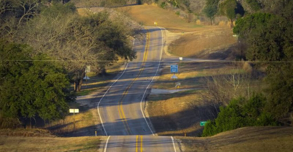
1. Willow City Loop (Fredericksburg)
")
Spring transforms this 13-mile loop into one of the most photographed stretches of asphalt in the state. When wildflower season peaks between late March and early May, the roadside explodes with bluebonnets, Indian paintbrush, and phlox painting the hillsides in waves of purple, orange, and pink. Families pull over constantly to snap photos, but even on busy weekends, the road never feels crowded because everyone’s moving at their own relaxed pace.
The loop starts just north of Fredericksburg off Ranch Road 1323 and curves through working ranches where cattle graze among the blooms. Stone fences line parts of the route, and old oaks provide shady spots perfect for a picnic break. You’ll pass a few small farms selling peaches or honey depending on the season, and locals are usually happy to chat about the best spots currently blooming.
Even outside wildflower season, this drive delivers charm. Summer brings green pastures dotted with lazy cattle, while fall colors the landscape in golds and russets. Winter can be surprisingly pretty when the oaks stand bare against bright blue skies.
The road itself is narrow and winding with some steep sections, so take it slow and watch for deer, especially around dawn and dusk.
Plan about 45 minutes if you’re just driving through, but most people spend two hours or more stopping for photos and soaking in the views. Bring a camera, some water, and maybe a blanket for an impromptu roadside rest. There’s something genuinely peaceful about being surrounded by nothing but rolling hills and wildflowers as far as you can see.
The Willow City Loop reminds you that sometimes the journey really is better than the destination, especially when that journey looks this good.
2. Devil’s Backbone / Ranch Road 32 (Wimberley)
")
Perched along a limestone ridge between Wimberley and Blanco, this route earned its dramatic name from the rocky spine it follows. The elevation gives you sweeping views on both sides, with valleys dropping away to reveal layers of hills fading into the distance. On clear days, you can see for miles, and sunset here is absolutely worth planning your drive around.
The light turns everything golden, and you understand why photographers obsess over this stretch.
Ranch Road 32 climbs steadily from Wimberley, gaining elevation as it winds along the ridge. Pull-offs appear regularly, and you should use them because the views deserve more than a glance through the windshield. Look for hawks riding thermals above the valleys, and in spring, wildflowers carpet the lower elevations in color.
The contrast between the rocky ridge and the green valleys creates a landscape that feels more dramatic than you’d expect from central Texas.
The road itself is smooth and well-maintained, making it popular with motorcyclists who appreciate the curves and elevation changes. Traffic stays light most days, though weekends bring more visitors exploring the area between Austin and San Antonio. Several hiking trails branch off from the main route if you want to stretch your legs, and the nearby Fischer Store makes a good pit stop for cold drinks and local gossip.
Budget about 30 minutes for the drive itself, but give yourself an hour or more to really enjoy it. The Devil’s Backbone connects nicely with other scenic routes in the area, so you can easily string together a longer loop. Bring binoculars if you’re into birdwatching, and definitely don’t skip the overlooks.
This ridge offers some of the best panoramic views in the Hill Country without requiring any hiking or special access.
3. River Road (New Braunfels)
")
Following the curves of the Guadalupe River, this route trades big vistas for intimate beauty. Massive cypress trees create a canopy over parts of the road, dappling the pavement with shade and giving the whole drive a cool, peaceful feeling even on hot summer days. The river appears and disappears through the trees, sometimes running right alongside the road where you can see kayakers floating past or families wading in the shallows.
River Road stretches from New Braunfels toward Gruene, passing through some of the prettiest riverside real estate in central Texas. Old stone buildings pop up here and there, remnants of German settlers who recognized good land when they saw it. Modern vacation homes mix with historic properties, but everything stays low-key and fits the natural setting.
You’ll cross several small bridges where you can glimpse the river flowing over limestone ledges.
The road gets busier during summer tubing season when everyone heads to the river, but early mornings stay quiet and lovely. Spring brings high water that rushes dramatically over the rocks, while fall offers cooler temperatures perfect for a leisurely drive with the windows down. Winter reveals the river’s structure when the leaves drop, showing off the limestone banks and clear green water that makes the Guadalupe so popular.
Watch for cyclists sharing the road, especially on weekends when this route attracts serious riders training on the rolling terrain. Several public river access points let you stop and dip your toes in, and a few riverside restaurants offer patios where you can grab lunch with a view. The whole drive only takes 20 minutes if you push through, but that defeats the purpose.
This is a road for meandering, for pulling over when something catches your eye, for remembering that rushing everywhere means missing the good stuff.
4. Ranch Road 337 (Leakey)
")
Motorcyclists call this the best riding road in Texas, and once you experience the curves and elevation changes, you’ll understand the hype. Ranch Road 337 drops and climbs through some of the most dramatic terrain in the Hill Country, with tight switchbacks and long sweeping curves that demand your attention. The road follows natural contours, never fighting the landscape, which means every turn reveals something new.
Starting from Leakey and heading toward Vanderpool, the route passes through country that feels almost mountainous by Texas standards. Steep hillsides covered in juniper and oak rise on one side while valleys fall away on the other. During wet years, small waterfalls appear along the roadside, and the Frio River valley stays green even when surrounding areas turn brown.
You’ll gain and lose hundreds of feet of elevation, making your ears pop and your heart race a little.
The famous “Three Sisters” section features particularly challenging curves that have humbled overconfident drivers for decades. Signs warn you to slow down, and you should listen because these turns come up faster than they look. But the reward is worth the caution—views open up between curves showing layer after layer of hills stretching toward the horizon.
In fall, the changing leaves add color to the landscape, while spring wildflowers soften the rocky terrain.
Plan at least an hour for the full stretch, more if you want to stop at overlooks or grab lunch in Leakey or Vanderpool. Both small towns offer basic services and friendly locals who can point you toward other great drives in the area. Fill your tank before you start because gas stations are few and far between.
This road rewards smooth driving and patience, punishing anyone who tries to rush. Take it at your own pace, respect the curves, and enjoy one of the finest driving experiences Texas offers.
5. Farm Road 170 / River Road (Presidio)
")
Out in far West Texas where the landscape turns genuinely wild, Farm Road 170 hugs the Rio Grande through some of the most remote and spectacular country you’ll find anywhere. This isn’t gentle Hill Country prettiness—this is raw desert beauty with towering canyon walls, the river snaking through the valley below, and mountains rising in the distance. The scale of everything out here makes you feel pleasantly small and reminds you just how big Texas really is.
The road runs between Presidio and Study Butte, roughly following the river for about 50 miles of continuously stunning views. Sheer cliffs drop straight down to the water in places, while elsewhere the road climbs high above the valley offering panoramic vistas. You’ll pass through tiny settlements that barely qualify as towns, places where a few hardy souls have carved out lives in this harsh but beautiful environment.
Gas up before you start and bring plenty of water because services are extremely limited.
Wildlife appears regularly if you keep your eyes open. Roadrunners dash across the pavement, hawks circle overhead, and if you’re lucky, you might spot bighorn sheep on the rocky slopes. The vegetation changes as you drive, from creosote and ocotillo to cottonwoods near the river.
Sunrise and sunset paint the canyon walls in shades of orange and red that photographs never quite capture. The light out here has a quality you don’t find in more humid parts of the state.
Allow at least two hours for the drive, preferably more because you’ll want to stop frequently. Several pull-offs provide safe places to park and soak in the views or walk down closer to the river. The road itself is paved and generally well-maintained, though watch for occasional washouts after heavy rains.
Cell service is nonexistent for much of the route, which feels surprisingly refreshing once you accept it. This drive offers solitude and scenery on a grand scale, perfect for anyone craving genuine wilderness and wide-open spaces.
6. Davis Mountains Scenic Loop (Fort Davis)
")
Rising unexpectedly from the desert, the Davis Mountains create their own climate and ecosystem that feels nothing like the surrounding landscape. The scenic loop circles through these peaks, climbing into pine forests and mountain meadows where temperatures run 10 to 15 degrees cooler than the valleys below. You’ll drive past the McDonald Observatory, where some of the world’s clearest night skies attract astronomers and stargazers from everywhere.
The 75-mile loop starts and ends in Fort Davis, combining Highway 118 and Highway 166 through terrain that surprises anyone expecting typical West Texas desert. Ponderosa pines grow at higher elevations, creating shaded stretches that feel more like Colorado than Texas. Meadows open up between the trees, and in summer, wildflowers add splashes of color.
Several scenic overlooks let you pull off and take in views that stretch for miles across alternating mountains and valleys.
Fort Davis National Historic Site sits right in town, worth a stop if you’re interested in frontier military history. The town itself maintains a charming mountain village atmosphere with local shops and restaurants that stay busy without feeling touristy. Highway 118 north of town passes through particularly pretty country as it climbs toward the observatory.
The road is well-maintained but includes some steep grades and sharp curves that require attention.
Give yourself at least three hours to complete the full loop with stops, more if you want to explore any of the hiking trails or visit the observatory. Spring and fall offer the most comfortable temperatures, though summer stays pleasant at elevation. Winter can bring occasional snow, which transforms the mountains into a genuinely magical landscape.
Bring layers because temperatures vary significantly with elevation changes. The Davis Mountains prove that Texas contains more geographical diversity than most people realize, and this scenic loop showcases that variety beautifully.
7. Park Road 4 (Burnet)
")
Winding through Longhorn Cavern State Park, this short but sweet route packs impressive scenery into just a few miles. The road curves through classic Hill Country landscape where limestone outcroppings push through thin soil and scrubby oaks create a textured canopy. Inks Lake appears through the trees, its blue waters contrasting beautifully with the rocky shores and green vegetation.
It’s the kind of drive that makes you wish it was longer.
Park Road 4 connects to Park Road 4 in a loop that takes maybe 20 minutes if you’re just driving, but most people stretch it into an hour or more by stopping at overlooks and trail heads. The road passes right by Longhorn Cavern, where you can tour underground chambers formed millions of years ago. Above ground, the landscape rolls gently with enough elevation change to keep things interesting.
Several picnic areas offer shaded spots perfect for a lunch break with a view.
Inks Lake State Park sits at one end of the route, providing water access and camping if you want to extend your visit. The lake stays relatively full even during droughts because it’s fed by the Colorado River, making it popular with boaters and fishermen. Kayakers paddle along the shoreline, and you’ll often see people swimming from the rocky beaches.
The park maintains several hiking trails that branch off from the main road, ranging from easy nature walks to more challenging climbs.
Spring wildflowers carpet the roadsides and meadows, while fall brings migrating birds stopping to rest near the water. Summer gets hot, but the lake provides cooling relief and the oaks offer decent shade. Winter stays mild enough for comfortable driving and hiking.
The whole area feels more developed than some other scenic drives on this list, with good facilities and clear signage, making it perfect for families or anyone wanting easy access to Hill Country beauty without venturing too far off the beaten path.