Texas isn’t just about wide-open plains and big cities. Hidden across the state are some of the most stunning hiking trails in the country, from desert canyons to forested mountains. Whether you’re a first-timer looking for an easy stroll or an experienced hiker ready to tackle a challenging peak, Texas has a trail with your name on it.
These 12 unforgettable hikes showcase the incredible diversity of the Lone Star State’s landscapes and offer adventures that will stick with you long after you’ve left the trail.
1. Lost Mine Trail (Big Bend National Park)
")
Standing at the edge of Lost Mine Trail’s overlook feels like you’ve reached the top of the world. This moderate 4.8-mile round-trip hike climbs through the Chisos Mountains, rewarding you with jaw-dropping views of pine-covered peaks, deep canyons, and the vast Chihuahuan Desert stretching toward Mexico. The trail gains about 1,100 feet in elevation, but the steady climb is broken up by plenty of scenic spots where you can catch your breath and snap photos.
What makes this hike special is how the landscape transforms as you ascend. You’ll start among desert shrubs and cacti, then gradually enter cooler forested areas with towering pines and junipers. Wildlife sightings are common here—keep your eyes peeled for deer, javelinas, and a variety of birds that call these mountains home.
The trail is well-maintained and clearly marked, making it accessible for families with older kids or anyone with moderate fitness levels. Morning hikes are particularly magical when the rising sun paints the mountains in shades of pink and gold. Just remember to bring plenty of water, as Big Bend’s dry climate can sneak up on you even in cooler months.
Plan to spend about three to four hours on the trail, including time to soak in those incredible views from the end point. The overlook provides a perfect spot for a snack break while you gaze across one of the most remote and beautiful corners of Texas. This trail captures everything that makes Big Bend special—rugged beauty, solitude, and vistas that seem to go on forever.
It’s the kind of hike that reminds you why Texas wilderness deserves a spot on every outdoor lover’s bucket list.
2. Gorman Falls Trail (Colorado Bend State Park)
")
Gorman Falls is Texas’s best-kept secret, a 70-foot waterfall that seems impossibly lush for the Hill Country. Getting there requires a 3-mile round-trip hike that’s moderately challenging, with rocky terrain and a steep descent near the end. But once you catch your first glimpse of water tumbling over moss-covered limestone cliffs, you’ll understand why this hike has such a devoted following among Texas outdoor enthusiasts.
The trail winds through classic Hill Country landscape—juniper trees, prickly pear cacti, and limestone outcroppings that tell the story of ancient seas. As you approach the falls, the vegetation becomes noticeably greener and more tropical-looking, a stark contrast to the drier surroundings. The constant moisture from the falls creates a microclimate that supports ferns, mosses, and plants you wouldn’t expect to find in Central Texas.
Timing your visit is crucial. The falls flow year-round, but they’re most impressive after spring rains when the water volume increases dramatically. Summer visits mean you’ll share the trail with more people, but the cool mist from the falls provides welcome relief from the Texas heat.
Wear sturdy shoes with good traction—the rocks can be slippery, especially on the final descent to the viewing area.
Photography enthusiasts love this spot because the falls change character throughout the day as sunlight filters through the trees at different angles. Early morning offers softer light and fewer crowds, while afternoon sun creates dramatic contrasts on the cliff face. The hike back involves a strenuous climb, so pace yourself and take breaks as needed.
This trail proves that Texas has waterfalls worth traveling for, hidden gems that rival more famous destinations in other states.
3. McKittrick Canyon Trail (Guadalupe Mountains National Park)
")
The 4.8-mile round-trip trail to Pratt Cabin follows a flowing creek through a desert oasis, passing under towering canyon walls and through groves of bigtooth maples, Texas madrones, and oaks. During autumn, this becomes the most popular hike in the Guadalupe Mountains, and for good reason—the fall foliage rivals anything you’d see in New England.
The trail is relatively easy, with minimal elevation gain as it follows the canyon floor. You’ll cross the creek several times on well-placed stepping stones, so waterproof boots come in handy during wetter seasons. The sound of running water accompanies you throughout the hike, a rare treat in West Texas where water is precious and streams are often dry.
Pratt Cabin, your turnaround point, sits in a picturesque meadow surrounded by towering trees. Built in the 1930s by geologist Wallace Pratt, who eventually donated this land to create the national park, the cabin represents a time when this canyon served as a private retreat. Interpretive signs tell the story of the area’s geology and human history, adding educational value to the scenic experience.
Peak fall color typically occurs in late October and early November, but the exact timing varies with weather patterns. Even outside autumn, this hike delights with its lush vegetation, diverse wildlife, and the simple pleasure of walking beside a mountain stream. Birds are abundant here—over 300 species have been recorded in the park, with many frequenting this water-rich canyon.
Arrive early during fall weekends, as parking fills quickly and the park service limits access to protect the fragile ecosystem.
4. Santa Elena Canyon Trail (Big Bend National Park)
")
Walking into Santa Elena Canyon feels like entering a natural cathedral. Sheer limestone walls rise 1,500 feet on both sides of the Rio Grande, creating one of the most dramatic landscapes in Texas. The 1.7-mile round-trip trail is short but incredibly rewarding, beginning with a climb up concrete stairs before leveling out along the river.
This hike is perfect for families or anyone who wants maximum visual impact with minimal distance.
The trail starts with a wade across Terlingua Creek, which can vary from ankle-deep to impassable depending on recent rains. During dry seasons, the crossing is easy, but always check conditions at the visitor center before heading out. Once across, you’ll climb a series of steps that switchback up the canyon wall, offering increasingly impressive views of the narrow gorge below.
At the top of the stairs, the trail levels out and follows a ledge carved into the Mexican side of the canyon. Looking up, you’ll see layers of limestone that formed at the bottom of an ancient sea millions of years ago. Looking down, the Rio Grande flows peacefully through the narrow gap it carved over countless centuries.
The scale is humbling—these walls make even the tallest person feel tiny.
The trail ends at a point where the canyon narrows dramatically, and the walls seem to close in overhead. Many hikers sit here for a while, listening to the river and soaking in the geology lesson written in stone all around them. Early morning and late afternoon offer the best lighting for photography, with the sun illuminating one wall while leaving the other in shadow.
Bring water, but this short hike won’t require the same preparation as longer Big Bend trails. It’s an absolute must-do that showcases the park’s most iconic feature.
5. North Franklin Mountain Trail (Franklin Mountains State Park)
")
El Paso’s backyard mountain range offers some of the best urban hiking in Texas, and North Franklin Mountain Trail is the crown jewel. This challenging 9-mile round-trip hike climbs over 2,000 feet to reach the summit of North Franklin Peak, the highest point in the Franklin Mountains at 7,192 feet. From the top, you’ll enjoy panoramic views of El Paso, Ciudad Juárez, and three states—Texas, New Mexico, and the Mexican state of Chihuahua.
The trail doesn’t mess around. Right from the trailhead, you’ll start climbing through classic Chihuahuan Desert terrain filled with ocotillos, prickly pears, and lechuguilla agaves. The path is rocky and steep in sections, requiring good fitness and sturdy hiking boots.
Switchbacks help ease the grade, but this is definitely a workout that’ll leave your legs feeling accomplished.
As you gain elevation, the desert vegetation gradually changes, with more juniper trees appearing at higher altitudes. The views improve with every step, expanding to reveal more of the sprawling city below and the surrounding desert mountains. On clear days, you can see for miles in every direction, making the effort feel absolutely worthwhile.
Timing is everything on this trail. Summer temperatures can be dangerously hot, so most experienced hikers tackle this one in fall, winter, or early spring. Start early regardless of season—morning hikes mean cooler temperatures and better lighting for those summit photos.
Bring at least three liters of water per person, as there’s no shade and no water sources along the way.
The summit itself is marked by a register where you can sign your name and read entries from other hikers who’ve made the climb. It’s a small tradition that creates a sense of community among those who’ve earned these views. This trail rewards determination with some of the best vistas in West Texas.
6. Caprock Canyons / Haynes Ridge Overlook Trail (Caprock Canyons State Park)
")
The Texas Panhandle surprises visitors with its rugged beauty, and Caprock Canyons delivers scenery that rivals more famous Western parks. The 2.5-mile round-trip Haynes Ridge Overlook Trail climbs onto the caprock itself, offering sweeping views of colorful canyons, red rock formations, and the vast plains beyond. This moderate hike gives you a taste of Panhandle geology without requiring a full day commitment.
The trail begins at the South Prong Trailhead and immediately starts climbing through juniper-dotted hillsides. The path is well-marked but rocky, so watch your footing as you ascend. As you gain elevation, the landscape opens up, revealing layers of red, orange, and tan sedimentary rock that tell millions of years of geological history.
These formations were once part of an ancient sea floor, later uplifted and carved by wind and water into the dramatic canyons you see today.
One of the park’s most famous residents, the official Texas State Bison Herd, roams freely throughout Caprock Canyons. While you might not see them from Haynes Ridge, knowing these magnificent animals share the landscape adds to the wild feeling of the place. The park is also home to aoudad sheep, originally from North Africa, which have found a home in these rocky canyons.
The overlook itself provides a perfect spot for a snack break and photo session. You’ll see the canyon system spreading out below, with the caprock forming a distinct geological boundary between the upper plains and the carved canyons. The contrast between the flat grasslands above and the eroded canyons below illustrates how this landscape formed over millions of years.
Visit in spring when wildflowers add splashes of color to the red rock backdrop, or in fall when cooler temperatures make hiking more comfortable. This trail proves the Panhandle has hidden treasures waiting for those willing to explore beyond the interstate.
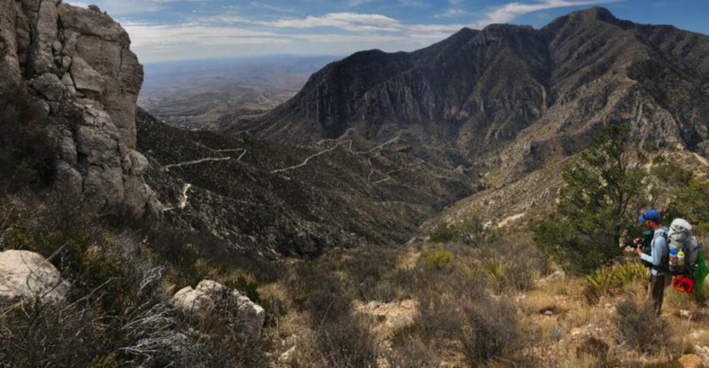
7. Guadalupe Peak Trail (Guadalupe Mountains National Park)
")
Reaching the highest point in Texas requires commitment, but Guadalupe Peak Trail delivers an accomplishment you’ll remember for life. This strenuous 8.4-mile round-trip hike climbs 3,000 feet from the trailhead to the summit at 8,751 feet above sea level. It’s tough, no question about it, but thousands of hikers make the climb each year to stand on top of Texas and sign the summit register.
The trail wastes no time getting steep. From the moment you leave the parking lot, you’re climbing through switchbacks that zigzag up the mountain’s southern face. The lower sections pass through desert vegetation—yuccas, agaves, and scattered shrubs adapted to the harsh, dry conditions.
As you gain elevation, the plant life changes, with more trees appearing and temperatures dropping noticeably.
About halfway up, many hikers pause at a natural saddle that offers the first really impressive views back toward the visitor center and across the salt flats to the west. This is a good place to catch your breath, drink some water, and mentally prepare for the second half of the climb, which includes some of the steepest sections.
The final push to the summit involves scrambling over limestone boulders and navigating rocky terrain that requires careful foot placement. Then suddenly, you’re there—standing at a stainless steel monument marking Texas’s highest point. The 360-degree views are absolutely stunning, with New Mexico’s mountains visible to the north and Mexico’s peaks to the south.
On clear days, you can see over 100 miles in multiple directions.
Most hikers need five to seven hours for the round trip, including time at the summit. Start early to avoid afternoon thunderstorms, which are common in summer months and can be dangerous on the exposed upper mountain. Bring plenty of water—at least three liters per person—along with snacks, layers for changing temperatures, and a headlamp just in case you’re on the trail longer than planned.
This hike earns every bit of its challenging reputation.
8. Lost Maples East Trail (Lost Maples State Natural Area)
")
Lost Maples State Natural Area earned its name from the isolated stands of bigtooth maples that somehow ended up in the Texas Hill Country, far from their usual mountain habitats. The East Trail, a 4.8-mile loop, takes you through the heart of this special ecosystem, following a clear creek through limestone canyons where these maples put on a spectacular fall color show that draws visitors from across the state.
The trail begins near the park headquarters and quickly enters a shaded canyon where the Sabinal River flows over limestone bedrock. You’ll cross the river several times on strategically placed stepping stones—fun during normal flows but potentially impassable after heavy rains. The sound of running water and the shade from towering trees make this section particularly pleasant during hot Texas summers.
As the trail climbs out of the canyon, you’ll gain elevation through rockier terrain with more exposure to sun. The views from the upper sections reveal the rugged Hill Country landscape, with layers of limestone cliffs and valleys covered in juniper and oak. Several scenic overlooks provide perfect spots for photos and rest breaks before you descend back into the maple-filled canyon.
Fall is obviously the star season here, typically peaking in late October or early November when the maples turn brilliant shades of red, orange, and yellow. The park becomes extremely crowded during peak color weekends, with entrance sometimes limited when parking lots fill. Visit on weekdays if possible, or arrive very early on weekends to secure parking and enjoy the trail before crowds arrive.
Even outside fall, Lost Maples offers excellent hiking through diverse ecosystems. Spring brings wildflowers and flowing water, while winter provides solitude and clear views through bare branches. The trail is moderately challenging with several steep sections, but most hikers with reasonable fitness can complete the loop in three to four hours.
Bring plenty of water, as Texas heat can be intense even in fall.
9. Lighthouse Trail (Palo Duro Canyon State Park)
")
Palo Duro Canyon, often called the Grand Canyon of Texas, showcases its most famous feature on the Lighthouse Trail. This 5.7-mile round-trip hike leads to a towering rock formation that resembles a lighthouse, standing sentinel over the colorful canyon. It’s the park’s most popular trail, and once you see that distinctive red rock spire rising from the canyon floor, you’ll understand why it draws so many visitors.
The trail starts near the canyon floor and follows a relatively flat path for the first couple miles, making it accessible for families and casual hikers. You’ll walk through classic Panhandle canyon scenery—juniper trees, prickly pear cacti, and colorful layers of red, orange, and white rock that represent millions of years of geological history. The formations here are part of the same rock layers visible at the Grand Canyon, just older and from different geological periods.
As you approach the Lighthouse, the trail becomes sandier and starts to climb. The final section involves ascending a slope of loose red sand and gravel, which can be challenging in the heat. But then you’re there, standing at the base of a 310-foot rock pillar that has become the symbol of Palo Duro Canyon.
The Lighthouse itself is actually softer rock capped by a harder layer that has protected it from erosion while surrounding material wore away.
Photography enthusiasts love this trail because the Lighthouse looks different depending on the time of day and angle of sunlight. Early morning and late afternoon provide the most dramatic lighting, with long shadows and warm colors that make the red rock glow. Midday light can be harsh, but it also brings out the subtle color variations in the rock layers.
Plan for about three to four hours to complete the hike comfortably. Summer heat can be brutal—temperatures regularly exceed 100 degrees—so spring and fall offer more pleasant conditions. Bring at least two liters of water per person, sun protection, and snacks.
This trail delivers iconic Texas scenery that proves the Panhandle has natural wonders worth traveling for.
10. Summit Trail (Enchanted Rock State Natural Area)
")
Enchanted Rock rises from the Texas Hill Country like a massive pink bubble, a 425-foot granite dome that has attracted humans for thousands of years. The Summit Trail is the park’s most direct route to the top, a steep 0.6-mile climb that gains over 400 feet in elevation. It’s short but challenging, and the 360-degree views from the summit make every step worthwhile.
The trail begins at the base of the massive rock and heads straight up the sloping granite face. There’s no shade and little vegetation on the dome itself, so you’re essentially climbing bare rock under the Texas sun. The granite can be slippery, especially after rain or early morning dew, so many hikers appreciate the metal cables installed along steeper sections to provide handholds.
As you ascend, pause occasionally to look back at the expanding views of the Hill Country stretching in all directions. Small depressions in the rock called vernal pools hold water after rains, creating temporary ecosystems that support unique plants and animals adapted to these harsh conditions. The rock itself is part of a massive underground granite formation called a batholith, most of which remains buried beneath the surface.
The summit offers a surprisingly large area to explore, with multiple high points and interesting rock formations to investigate. Many visitors spend considerable time up top, finding spots to sit and soak in the views while catching their breath from the climb. On clear days, you can see for miles across the Hill Country’s rolling hills and valleys.
Enchanted Rock’s name comes from Native American legends about the rock making creaking and groaning sounds, which geologists now explain as the granite expanding and contracting with temperature changes. Whether or not you hear the rock’s voice, you’ll certainly feel its presence—this is one of the most distinctive natural landmarks in Texas.
The park limits daily visitors to protect the fragile ecosystem, so arrive early, especially on weekends and holidays. Once parking lots fill, new visitors must wait for others to leave before entering. The hike down requires careful footing on the smooth granite, but most people complete the round trip in about an hour.
11. Wolf Mountain Trail (Pedernales Falls State Park)
")
Wolf Mountain Trail offers one of the most rewarding workouts in the Texas Hill Country, a challenging 7.5-mile loop that climbs to the highest point in Pedernales Falls State Park. From the summit, you’ll enjoy panoramic views of the surrounding hills, the Pedernales River valley, and on clear days, the skyline of Austin in the distance. This trail is for hikers who want elevation gain, varied terrain, and a sense of accomplishment.
The trail starts near the park headquarters and immediately begins climbing through classic Hill Country vegetation—juniper, oak, and prickly pear cacti scattered across limestone hillsides. The path is rocky and technical in sections, requiring attention to foot placement and occasional scrambling over limestone outcroppings. Multiple creek crossings add variety and challenge, especially after recent rains when the water runs higher.
As you gain elevation, the views become increasingly impressive. The trail passes through different ecosystems, from dry hilltops with sparse vegetation to shaded creek bottoms with lush plant growth. Wildlife is abundant here—you might spot white-tailed deer, armadillos, or a variety of Hill Country birds.
The park is also home to the endangered golden-cheeked warbler, which nests in mature juniper-oak woodlands during spring and summer.
The summit area provides several viewpoints where you can rest and take in the scenery. Unlike some Texas hikes where the landscape is relatively flat, Wolf Mountain Trail delivers genuine elevation changes that make the views feel earned. The descent involves careful navigation of rocky sections, with some steep grades that can be tough on the knees.
Most hikers complete the loop in four to five hours, depending on pace and how long they spend enjoying the views. Bring plenty of water—the park recommends at least two liters per person—along with snacks and proper hiking boots. Spring wildflowers add color to the landscape, while fall brings cooler temperatures and less crowded trails.
This hike showcases why the Hill Country has become a favorite destination for Texas outdoor enthusiasts seeking challenging terrain and beautiful scenery.