Texas isn’t just about wide-open plains and bustling cities. Hidden across the state are hiking trails that lead to jaw-dropping landscapes so stunning they almost seem impossible. From towering canyon walls to sweeping desert vistas, these easy hikes prove you don’t need to be an expert mountaineer to witness nature at its most dramatic and beautiful.
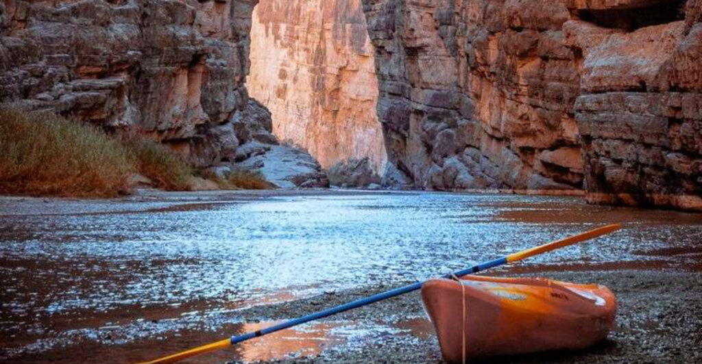
1. Santa Elena Canyon Trail (Big Bend National Park)
")
Walking between 1,500-foot limestone walls while the Rio Grande flows quietly beside you feels like stepping into another dimension. Santa Elena Canyon Trail delivers one of the most spectacular sights in West Texas without asking much from your legs. The 1.7-mile round-trip path starts with a short but steep staircase that gets your heart pumping before leveling out along the river.
Once you’re inside the canyon, the sheer scale of the rock walls becomes almost overwhelming. These ancient cliffs tower above you on both sides, creating a natural corridor that seems carved by giants. The contrast between the rust-colored stone and the blue sky above creates photo opportunities at every turn.
Most hikers complete this trail in under an hour, making it perfect for families or anyone looking to experience Big Bend’s grandeur without committing to an all-day adventure. The path is well-maintained and relatively flat once you’ve conquered those initial steps. Early morning visits offer cooler temperatures and softer light that makes the canyon walls glow.
Water levels in the Rio Grande can affect trail access, especially after heavy rains upstream. When the river runs high, the trail may close temporarily for safety. Check conditions at the visitor center before making the drive out, since Santa Elena sits about 30 miles from park headquarters.
The canyon feels especially magical during golden hour when sunlight illuminates the upper portions of the cliffs while shadows deepen below. Bring plenty of water even though the hike is short—the desert heat can sneak up on you. This trail proves that some of Texas’s most incredible landscapes are surprisingly accessible to everyone.
2. Window View Trail (Big Bend National Park)
")
Perched in the Chisos Basin, this 0.3-mile trail punches way above its weight in scenic payoff. The Window View Trail takes maybe fifteen minutes to walk, yet delivers a vista that photographers travel across the country to capture. You’re looking through a dramatic V-shaped notch in the mountains that frames the Chihuahuan Desert stretching endlessly beyond.
The trail itself couldn’t be easier—it’s practically a sidewalk winding through desert vegetation. Families with small children manage it without breaking a sweat. What makes this hike special isn’t the physical challenge but rather the destination, where the mountains create a natural picture frame around layers of distant peaks fading into blue haze.
Sunset transforms this spot into something truly magical. As golden light floods the desert floor below and shadows creep across the basin, the Window becomes a portal to watch day transition into night. Arrive about an hour before sunset to claim a good spot on the viewing platform, because this trail gets crowded during peak season.
The Window itself is actually a pour-off where rainwater drains from the basin, creating a 220-foot waterfall during storms. Even when dry, the geological formation tells the story of millions of years of erosion carving through solid rock. Oak Creek flows through this gap during wetter times, eventually joining Cattail Creek far below.
Because the trail sits at over 5,000 feet elevation, temperatures stay noticeably cooler than the desert floor. That mountain air feels refreshing even in summer months. The Chisos Basin area offers several other hikes if you want to explore further, but Window View Trail gives you maximum wow factor with minimum effort—a rare and wonderful combination in any hiking destination.
3. Lighthouse Trail (Palo Duro Canyon State Park)
")
America’s second-largest canyon hides in the Texas Panhandle, and the Lighthouse Trail leads straight to its most iconic landmark. This 5.75-mile round-trip hike crosses the canyon floor before climbing toward a 75-foot rock pillar that rises like a beacon from the colorful badlands. The trail name makes perfect sense once you spot this massive hoodoo standing sentinel over the landscape.
Starting from the canyon floor, you’ll cross a usually-dry creek bed before the path begins its gradual ascent. Red, orange, and white layers of rock tell 250 million years of geological history in brilliant color bands. The terrain feels almost Mars-like with its otherworldly rock formations and sparse vegetation adapted to the harsh environment.
Despite being the park’s most popular trail, the Lighthouse hike remains surprisingly peaceful. The sheer size of Palo Duro Canyon absorbs crowds easily, and you’ll often find yourself alone with the landscape for long stretches. The final approach to the Lighthouse formation requires navigating some loose rock and steeper sections, but nothing too technical.
Standing at the base of the Lighthouse formation is genuinely awe-inspiring. This towering pillar of Permian-age rock has withstood erosion that carved away surrounding softer stone. It’s a reminder of the immense time scales involved in shaping landscapes—this formation has stood here for millions of years and will likely stand for millions more.
Summer heat makes this trail brutal during midday hours, with temperatures regularly exceeding 100 degrees and virtually no shade. Spring and fall offer the best hiking conditions, with wildflowers adding splashes of yellow and purple to the red rock canvas. Start early or go late to avoid the worst heat, and bring more water than seems reasonable—the dry air and sun exposure are deceptive.
4. Gorman Falls Trail (Colorado Bend State Park)
")
Hidden deep in the Hill Country, Gorman Falls rewards hikers with one of Texas’s most unexpected sights—a 70-foot waterfall tumbling over brilliant green travertine formations. The 3-mile round-trip trail winds through rocky terrain and across several creek crossings before revealing this natural wonder. Unlike most Texas waterfalls that only flow after heavy rains, Gorman Falls runs year-round thanks to underground springs.
The hike itself qualifies as moderately challenging rather than easy, with some steep descents and rocky sections that require careful footing. Those creek crossings can range from simple rock-hopping to potentially wet feet depending on recent rainfall. Sturdy hiking shoes with good traction make a significant difference on this trail.
What makes Gorman Falls truly special is the vibrant green moss and algae coating the travertine deposits. These living minerals create an emerald curtain that seems impossibly lush for Central Texas. The mineral-rich spring water continuously builds new layers of travertine while supporting this unique ecosystem of ferns, mosses, and specialized plants.
The viewing platform sits across the creek from the falls, providing excellent photo opportunities without disturbing the delicate formations. Getting closer to the falls requires wading through the creek, which many visitors choose to do on hot summer days. The mist from the waterfall creates a noticeably cooler microclimate that feels refreshing after the hike in.
Colorado Bend State Park requires advance reservations for the Gorman Falls hike, with limited daily permits to protect the area. This restriction keeps crowds manageable and preserves the pristine quality of the experience. The park also offers guided tours on weekends for those who want expert interpretation of the geology and ecology.
Book your permit well ahead if visiting during spring or fall when demand peaks.
5. Pedernales River Trail (Pedernales Falls State Park)
")
Following the Pedernales River downstream from the main falls area, this trail showcases the Hill Country at its most beautiful. The river has carved through layers of limestone over millennia, creating smooth rock shelves where water slides and pools in mesmerizing patterns. Depending on recent rainfall, you might find everything from gentle riffles to impressive cascades tumbling over the stone steps.
The trail itself offers multiple distance options, from a quick 1-mile out-and-back to longer explorations covering 7 miles round-trip. Most visitors stick to the first mile or two, which provides access to the best river views and swimming holes. The path stays relatively level as it follows the riverbank, with only minor elevation changes to navigate.
Cypress trees line the water’s edge, their roots gripping the limestone and creating natural sculptures. In fall, their needles turn golden-brown before dropping, while spring brings fresh green growth and wildflowers carpeting the hills. The contrast between the pale limestone, dark green foliage, and blue-green river water creates a color palette that seems almost too perfect.
Swimming and wading are popular activities along this trail, especially during summer when temperatures soar. The limestone pools stay refreshingly cool even in August heat. Always check current conditions and water levels before entering the river—flash floods can occur rapidly during storms, and the smooth rock becomes dangerously slippery when water levels rise.
Wildlife sightings are common along the Pedernales River Trail. White-tailed deer frequently browse near the water at dawn and dusk. Numerous bird species inhabit the riparian corridor, including great blue herons, belted kingfishers, and various songbirds.
Turtles sun themselves on rocks while fish dart through the clear pools. This trail offers a perfect blend of scenic beauty and natural history that captures the essence of the Texas Hill Country.
6. Summit Trail (Enchanted Rock State Natural Area)
")
Climbing a billion-year-old pink granite dome might sound intimidating, but the Summit Trail at Enchanted Rock is surprisingly manageable for most fitness levels. This 1-mile trek to the top gains about 425 feet of elevation, with the steepest sections concentrated near the beginning. Once you’ve pushed through that initial climb, the grade eases considerably as you approach the massive rock’s rounded summit.
The granite surface itself provides excellent traction when dry, though it becomes treacherously slippery after rain or morning dew. Painted markers guide the way up the bare rock face, though the route is usually obvious—just head toward the highest point. The exposed nature of this climb means zero shade, so sun protection and plenty of water are absolutely essential.
Reaching the summit delivers a 360-degree panorama of the Hill Country that seems to stretch forever. On clear days, you can see for miles in every direction, with rolling hills covered in oak and juniper fading into the distance. The top of Enchanted Rock features numerous weathered depressions called vernal pools that fill with rainwater and support unique ecosystems of tiny shrimp and specialized plants.
Weekends and holidays bring massive crowds to Enchanted Rock, often resulting in the park closing by mid-morning when capacity is reached. Arriving at opening time or visiting on weekdays significantly improves your experience. The summit area is large enough that even with crowds, you can find a quiet spot to sit and absorb the views.
Sunset from the top ranks among Texas’s most spectacular natural shows. As golden light washes across the granite and the sky transforms through shades of pink, orange, and purple, the rock seems to glow from within. Many hikers time their descent to catch the last light, though bringing a headlamp is wise since darkness falls quickly once the sun drops below the horizon.
7. Lakeshore Trail (Tyler State Park)
")
East Texas feels like a different state entirely, and the Lakeshore Trail at Tyler State Park showcases this region’s distinct personality. Towering loblolly pines create a canopy overhead while Spanish moss drapes from branches like natural decorations. The 2.5-mile loop hugs the shoreline of the park’s 64-acre lake, offering continuous water views through the forest.
Unlike the rocky, sun-baked trails of West Texas, this path stays shaded and relatively cool even during summer months. The forest floor is carpeted with pine needles that cushion each step, and the air carries the distinctive scent of pine resin. This trail feels more like something you’d find in the Deep South than the typical Texas landscape.
The lake itself attracts abundant wildlife. Great blue herons stalk the shallows while turtles sun themselves on fallen logs. During migration seasons, numerous waterfowl species stop here to rest and feed.
The dense forest provides habitat for woodpeckers, songbirds, and occasionally white-tailed deer that come to the water’s edge to drink.
Several spots along the trail offer perfect opportunities to sit and watch the lake. Wooden benches placed at scenic viewpoints invite you to pause and simply absorb the peaceful atmosphere. The water’s surface reflects the surrounding forest like a mirror on calm days, creating beautiful photographic compositions.
Spring brings wildflowers blooming along the trail edges, adding splashes of color to the predominantly green landscape. Fall offers its own rewards as hardwood trees scattered among the pines display brilliant autumn colors. Winter hiking here remains pleasant since temperatures rarely drop to uncomfortable levels, and the reduced foliage allows better views through the forest.
Tyler State Park sees far fewer visitors than more famous Texas destinations, meaning you’ll often have long stretches of trail entirely to yourself. This sense of solitude enhances the experience, allowing you to fully appreciate the natural sounds of the forest and lake without human interruption.
8. Eagle Point Trail (Caprock Canyons State Park)
")
Caprock Canyons might be lesser-known than Palo Duro, but it delivers equally stunning scenery with fewer crowds. The Eagle Point Trail climbs 2.5 miles one-way to a dramatic overlook where the entire canyon system spreads before you in layers of red, orange, and tan rock. The elevation gain of about 450 feet is steady but never overwhelming, making this a genuine easy-to-moderate hike.
Starting from the canyon floor, the trail switchbacks up the canyon wall through juniper and mesquite. As you gain elevation, the views progressively improve until reaching the final overlook where everything comes together. The sense of space and openness at Eagle Point is almost dizzying—you can see for miles across the breaks and canyons that define this rugged landscape.
This area is home to the official Texas State Bison Herd, and spotting these massive animals roaming the canyon is always thrilling. They typically graze in the lower areas but occasionally wander near the trail. Always maintain a safe distance—bison are wild animals and can be dangerous if approached.
Their presence adds an element of wildlife excitement that most Texas trails can’t match.
The rock formations at Caprock Canyons tell fascinating geological stories. You’re looking at Permian-age rocks similar to those at Palo Duro, but here the canyons have carved through the caprock escarpment in particularly dramatic fashion. Erosion continues to shape these formations, with new features emerging over geological time scales.
Weather can change rapidly in the Panhandle, so check forecasts before heading out. Strong winds are common and can make the exposed sections of trail challenging. Summer thunderstorms develop quickly, and you don’t want to be on an exposed ridgeline when lightning threatens.
Spring and fall offer the most comfortable hiking conditions with moderate temperatures and generally calmer winds. The remoteness of Caprock Canyons means you’ll likely share the trail with only a handful of other hikers, creating an intimate experience with this spectacular landscape.
9. Guadalupe Peak Base Trail (Guadalupe Mountains National Park)
")
Texas’s highest point towers 8,751 feet above sea level, but you don’t need to summit Guadalupe Peak to experience the grandeur of these mountains. The base trail offers a more accessible introduction to this remarkable landscape, following the lower slopes where the Chihuahuan Desert meets the mountains. This 4.2-mile round-trip hike provides stunning views without the grueling elevation gain required to reach the actual summit.
The trail winds through a landscape that seems impossibly rugged and beautiful. Massive limestone cliffs rise dramatically above the desert floor, their pale gray stone contrasting sharply with the deep blue sky. Agave plants, prickly pear cactus, and sotol dot the rocky terrain, all specially adapted to survive in this harsh environment.
During late summer and fall, the agave plants send up spectacular flowering stalks that can reach 15 feet high. These century plants actually bloom after 10-15 years rather than a full century, but the name captures how dramatic and rare these flowering events feel. The stalks attract hummingbirds and various insects, creating little oases of activity in the desert.
The geology here is absolutely fascinating. These mountains are the exposed remnants of an ancient reef that formed when this area lay beneath a tropical ocean 265 million years ago. You’re literally walking on fossilized marine organisms compressed into stone over unimaginable spans of time.
Careful observers can spot fossil imprints in the limestone along the trail.
Weather conditions at Guadalupe Mountains can be extreme. High winds are incredibly common, especially during spring months when gusts can exceed 60 mph. Winter brings snow and ice to higher elevations.
Summer afternoons often feature intense thunderstorms that develop rapidly over the peaks. Early morning starts provide the calmest conditions and best light for photography. The elevation and exposed nature of the trail mean temperatures run cooler than the surrounding desert, which actually makes summer hiking more pleasant here than at lower elevations.
10. Devil’s Hall Trail (Guadalupe Mountains National Park)
")
Walking through Devil’s Hall feels like entering a secret passageway carved through solid rock. This 4.2-mile round-trip trail leads to a narrow corridor where towering limestone cliffs close in from both sides, creating a natural hallway that’s both beautiful and slightly eerie. The name perfectly captures the otherworldly atmosphere of this geological formation.
The hike begins in Pine Springs Canyon, following a dry wash that occasionally runs with water after heavy rains. The path gains only about 650 feet of elevation, making it far less strenuous than many Guadalupe Mountains trails. Desert vegetation gives way to scattered ponderosa pines as you progress up the canyon—a surprising sight in what seems like pure desert country.
As you approach Devil’s Hall itself, the canyon walls gradually close in until you’re walking through a passage barely wide enough for two people side-by-side. The rock walls tower 100 feet overhead, their surfaces sculpted smooth by millions of years of erosion. Light filters down from above, creating dramatic shadows and highlighting the textures of the ancient limestone.
The Hiker’s Staircase, a natural rock formation near Devil’s Hall, looks almost too perfectly arranged to be natural. These massive limestone blocks have fractured and shifted into a stair-step pattern that hikers can carefully climb. It’s a popular photo spot and a great place to appreciate the forces that shape these mountains.
Spring brings wildflowers to the canyon, with various species blooming in succession from March through May. Columbines, penstemons, and Indian paintbrush add splashes of color to the rocky landscape. Fall offers cooler temperatures and occasional golden foliage from the scattered deciduous trees.
This trail sees moderate traffic compared to the Guadalupe Peak summit route, but it’s popular enough that you’ll encounter other hikers, especially on weekends. The combination of accessibility, unique geology, and dramatic scenery makes Devil’s Hall one of the park’s must-see destinations.
11. Scenic Overlook Trail (Davis Mountains State Park)
")
Perched at 5,000 feet elevation in the Davis Mountains, this trail delivers exactly what its name promises—sweeping views across some of West Texas’s most beautiful high country. The 1-mile loop is short enough for young children yet rewarding enough to satisfy serious hikers. From the overlook, you can see mountain ranges layering into the distance like waves of stone frozen in time.
The Davis Mountains are actually volcanic in origin, quite different from the limestone formations dominating much of Texas. These ancient volcanic rocks create a unique landscape with more vertical relief and different vegetation patterns than you’ll find elsewhere in the state. Grasslands cover the slopes while oak trees cluster in the drainages, creating a mosaic of habitats.
The trail itself is well-maintained and easy to follow, with interpretive signs explaining the natural and human history of the area. You’ll learn about the fort that once stood nearby, the volcanic geology, and the diverse wildlife that calls these mountains home. Black bears occasionally wander through the Davis Mountains, though sightings near the park are rare.
What makes this overlook special is the sense of remoteness it provides. Looking out across the mountains, you see very few signs of human presence—just endless ridges and valleys covered in native vegetation. The sky seems impossibly large and blue, while puffy clouds cast moving shadows across the landscape.
This is Texas at its most wild and unspoiled.
Sunrise and sunset transform the Davis Mountains into something magical. The volcanic rocks take on warm hues of pink, orange, and red as the light shifts. Shadows deepen in the valleys while the highest peaks glow.
Bird activity peaks during these times as well, with hawks and vultures riding thermal currents above the ridges. Night brings some of the darkest skies in Texas, making the park popular with stargazers. The McDonald Observatory sits just a few miles away, testament to the exceptional viewing conditions these mountains offer.
Even a short evening hike to the overlook can reward you with spectacular celestial displays once darkness falls.
12. Juniper Ridge Trail (Pedernales Falls State Park)
")
If you want to understand why people fall in love with the Texas Hill Country, the Juniper Ridge Trail provides the perfect introduction. This 2.5-mile loop climbs about 250 feet above the Pedernales River valley, offering panoramic views across the rolling limestone hills that define this landscape. The trail name comes from the abundant Ashe juniper trees covering the ridgeline, their twisted trunks and blue-green foliage creating the classic Hill Country look.
The trail surface alternates between rocky limestone sections and packed dirt paths. Some areas require careful foot placement over uneven stone, but nothing too technical. The elevation gain is gradual enough that most hikers handle it without difficulty, though you’ll definitely feel your legs working on the uphill sections.
From the ridgetop, you can see for miles across the Hill Country’s signature topography. These limestone layers were deposited at the bottom of an ancient sea, then uplifted and eroded into the scenic hills visible today. The white rock outcrops dotting the hillsides are the same formation that creates the waterfalls along the Pedernales River below.
Wildlife thrives in this mixed oak-juniper woodland. White-tailed deer browse among the trees while armadillos root through leaf litter searching for insects. Numerous bird species inhabit the area, including the endangered golden-cheeked warbler that nests in mature juniper bark during spring.
Listen for the distinctive buzzing song of these small yellow-and-black birds from March through July.
Spring wildflower season transforms this trail into a botanical showcase. Bluebonnets carpet open areas while Indian paintbrush adds splashes of red. Texas mountain laurel blooms in late February and early March, filling the air with a grape-soda-like fragrance.
Fall brings cooler temperatures and beautiful light that makes the limestone glow. Summer can be brutally hot with little shade on the exposed ridgetop sections, so early morning or late afternoon hikes work best during those months. The combination of river valley and ridgetop environments makes Juniper Ridge Trail a perfect sampler of Hill Country ecosystems and scenery.
13. Wolf Mountain Trail (Bastrop State Park)
")
The Lost Pines of Bastrop represent an ecological anomaly—a forest of loblolly pines growing 100 miles west of the main East Texas pine belt. Wolf Mountain Trail winds 2.6 miles through this unique woodland, climbing to the park’s highest point for views across the pine-covered hills. The trail’s name honors the red wolves that once roamed these forests, though they were extirpated from Texas decades ago.
These pines survived the devastating 2011 wildfire that burned over 96% of Bastrop State Park. Walking the trail today, you’ll see both the resilience of nature and the scars that remain. Young pines are growing vigorously among the burned trunks, creating a forest in transition.
Wildflowers have exploded in areas where the canopy opened, adding unexpected beauty to the recovering landscape.
The trail surface consists of sandy soil typical of this region. Unlike rocky Hill Country trails, your feet sink slightly with each step, making the hiking feel softer but also more tiring. The elevation gain to Wolf Mountain’s summit totals about 250 feet—not dramatic, but enough to get your heart rate up.
From the top, you can see the pattern of forest recovery across the hills. Areas with denser tree cover contrast with more open sections where grasses and shrubs dominate. The Lost Pines ecosystem is genuinely unique in Texas, supporting plant and animal species not found elsewhere in the state.
Bastrop bastard cabbage, an endangered plant species, grows only in this sandy post oak savanna habitat.
Summer heat can be oppressive even under the partial shade of recovering forest. The sandy soil reflects heat upward while absorbing moisture quickly, creating dry conditions. Spring and fall offer the most pleasant hiking weather, with moderate temperatures and wildflowers blooming along the trail edges.
Winter remains mild enough for comfortable hiking most days. The trail sees steady use from Austin-area residents but rarely feels crowded. This proximity to Austin makes Bastrop State Park a convenient escape from city life without requiring a long drive into more remote areas.
14. Rio Grande Village Nature Trail (Big Bend National Park)
")
A boardwalk trail through desert wetlands might seem like a contradiction, but the Rio Grande Village Nature Trail proves that even in harsh Big Bend, water creates oases of life. This 0.75-mile loop stays flat and easy, making it accessible for nearly everyone. The trail winds through a wetland area fed by a natural spring, creating habitat that contrasts dramatically with the surrounding Chihuahuan Desert.
Tall cattails line the waterways while cottonwood trees provide shade along the path. The sound of running water and bird calls replaces the desert silence, creating an atmosphere that feels transported from a completely different ecosystem. During migration seasons, this spot becomes a magnet for birds, with over 200 species recorded in the Rio Grande Village area.
The boardwalk sections keep your feet dry while allowing close observation of the wetland plants and animals. Turtles sun themselves on logs while fish dart through the clear water. Dragonflies patrol the air above the reeds, their iridescent bodies catching the light.
This small wetland supports an astonishing diversity of life thanks to the reliable water source.
Views across the Rio Grande into Mexico add an international dimension to the hike. The river here flows quietly between banks lined with cane and willow. Mexican villages are visible on the opposite shore, and you might hear sounds carrying across the water.
This border region has a unique cultural and ecological character that enriches the hiking experience.
Early morning offers the best wildlife viewing opportunities as animals come to drink and feed before the heat builds. The wetland stays noticeably cooler than surrounding areas thanks to evaporative cooling from the water and shade from the trees. Sunset brings beautiful light filtering through the cottonwoods and reflecting off the water.
This trail works perfectly as an evening stroll after a day of more strenuous Big Bend hiking. The combination of easy access, unique habitat, and abundant wildlife makes Rio Grande Village Nature Trail a must-visit spot that showcases a completely different side of Big Bend National Park.